BOTTOM LINE
Danger by aspect and elevation on slopes approaching 35° or steeper.
(click HERE for tomorrow's danger rating)
|
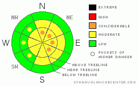
Danger Rose Tutorial
|
At and above treeline, most slopes have a Level 2 (MODERATE) avalanche danger and human triggered avalanches are possible. However, along the high ridges in the wind zone, pockets of Level 3 (CONSIDERABLE) avalanche danger exists and human triggered avalanches are likely, especially on steep wind drifted slopes that face North, Northeast, East and Southeast.
While isolated and difficult to initiate, the possibility of triggering a large, scary slide that breaks into the buried surface hoar still exists, especially in terrain where the rain crust is starting to break down or wasn’t thick and bomber to begin with. In terrain with these snowpack characteristics a Level 2 (MODERATE) avalanche danger will be found and human triggered avalanches are possible.
All other terrain has a Level 1 (LOW) avalanche danger. |
|
|
CURRENT CONDITIONS |

|
High pressure over the region allowed for skies to clear overnight and temperatures dove into the single digits. Winds are northwesterly, blowing 25-30 mph along the high ridges. The North Slope picked up 4”-6” of medium density snow in the past 24 hours. The further south you travel total snowfall amounts are cut in half. Excellent riding and turning conditions will be found today in wind sheltered terrain and low angle slopes feel surfy and reboundable. |
|
|
RECENT ACTIVITY |
|
|
|
THREAT #1 |

|
| WHERE |
PROBABILITY |
SIZE |
TREND |
|
|
|
|
| |
|
|
Over the next
24 hours.
|
|
|
Westerly winds cranked for most of yesterday morning, gusting into the 50’s and 60’s, mellowing out midday into the 30’s and 40’s. Wind drifts forming on the leeward side of upper elevation slopes facing Northeast, East and Southeast, may not be quite as sensitive as yesterday, but still have the potential to break a bit wider than you might expect. Today, you’ll want to ride defensively and gather information before getting into big terrain. Tweak small test slopes, like road cuts to see how they’re reacting before center-punching a big slope. |
|
|
THREAT #2 |

|
| WHERE |
PROBABILITY |
SIZE |
TREND |
|
|
|
|
| |
|
|
Over the next
24 hours.
|
|
|
While the chances of triggering an avalanche in the surface hoar are isolated, the consequences are severe, as evidenced by the large remotely triggered avalanche in the Smith & Morehouse area. The spooky thing about surface hoar is that you don't need to be on the slope to trigger it; you just have to be on a piece of terrain that is connected to that slope. The surface hoar is widespread across the range and remains intact and preserved in most locations. All that sits between us and this notoriously tricky layer is a crust. There are a few things you can do to hedge your bet today:
1. Be aware of what the snow feels like under your machine. If you feel the machine breaking through the crusts then it's time to find a new place to ride, immediately.
2. Avoid areas where the snowpack is thin & weak, like around rock outcroppings, especially in the periphery of the range.
3. Ride smart by only putting one rider on a slope at a time. The idea here is not to overload the crusts, so let your buddies dig themselves out. We don't need to stack more weight than necessary on the snow. |
|
|
MOUNTAIN WEATHER |

|
High pressure will maintain a north-northwest flow across northern Utah through much of the coming week. Today, look for mostly sunny skies with temperatures climbing into the low to mid 20’s. Overnight lows dip into the teens. Northwest winds should remain in the 15-25 mph range. Clouds increase late today into tonight, but there’s not much moisture associated with this feature. A second system Monday night or early Tuesday will take a more direct aim on northern Utah, likely producing accumulating snows. The remainder of the week looks partly cloudy with no real storms until late next weekend. |
|
|
GENERAL ANNOUNCEMENTS |
The information in this advisory expires 24 hours after the date and time posted, but will be updated by 7:00 AM Wednesday Jan. 26th.
If you’re getting out and about and trigger an avalanche or see anything interesting please drop me an email at craig@utahavalanchecenter.org or call 801-231-2170
The western Uinta advisory program is going full tilt and forecasts will be issued by 7:00 AM on Wednesday, Saturday, Sunday and all holidays. |
|
|
This information does not apply to developed ski areas or highways where avalanche control is normally done. This advisory is from the U.S.D.A. Forest Service, which is solely responsible for its content. This advisory describes general avalanche conditions and local variations always occur. |
|
This advisory provided by the USDA Forest Service, in partnership with:
The Friends of the Utah Avalanche Center, Utah Division of State Parks and Recreation, Utah Division of Emergency Management, Salt Lake County, Salt Lake Unified Fire Authority and the friends of the La Sal Avalanche Center. See our Sponsors Page for a complete list. |
