BOTTOM LINE
Danger by aspect and elevation on slopes approaching 35° or steeper.
(click HERE for tomorrow's danger rating)
|
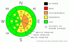
Danger Rose Tutorial
|
At and above treeline on slopes that face NE, E & SE the avalanche danger is Level 3 (Considerable), fresh sensitive windslabs averaging a foot in depth will be avalanching naturally and human triggered avalanches are likely. All other slopes at and above treeline have a mostly Level 2 (Moderate) avalanche danger.
There is a mostly Level 1 (Low) with pockets of Level 2 (Moderate) avalanche danger associated with persistent slab avalanches. While getting harder and harder to trigger, the possibility of triggering a large destructive slab avalanche originating in the surface hoar still exists, especially in the periphery of the range. |
|
|
CURRENT CONDITIONS |

|
It's in the mid twenties across the region this morning with winds streaming out of the west at a steady 40 mph, gusting as high as 60 mph ahead of a short wave disturbance that will bring a few inches our way this morning.
Riding conditions are currently excellent at and above treeline with about a foot of light density snow on top of the rain crust. |
|
|
RECENT ACTIVITY |
|
|
|
THREAT #1 |

|
| WHERE |
PROBABILITY |
SIZE |
TREND |

|
|
|
|
| |
|
|
Over the next
24 hours.
|
|
|
High winds, a small short wave storm burst en route and plenty of snow available for transport = fresh sensitive wind slabs. Today I expect a natural avalanche cycle on high and mid elevation NE, E & SE facing slopes. These windslabs will be sensitive to the weight of a rider & easy to trigger averaging a foot in depth with the potential to breakout across large pieces of terrain. Ride defensively by tweaking small test slopes to see how the fresh windslab is behaving before thinking about bigger terrain. The risk adverse will find the best riding in the more protected treed areas at mid elevation today.
I expect these windslabs to settle out quickly, so, take a break from the big terrain today & carefully re-evaluate tomorrow. |
|
|
THREAT #2 |

|
| WHERE |
PROBABILITY |
SIZE |
TREND |
|
|
|
|
| |
|
|
Over the next
24
hours.
|
|
|
While the chances of triggering an avalanche in the surface hoar (SH) are small, the consequences are extreme, as evidenced by this large remotely triggered avalanche in the Smith & Morehouse area. The spooky thing about surface hoar is that you don't need to be on the slope to trigger it; you just have to be on a piece of terrain that is connected to the slope. The SH is widespread across the range, and still intact in most locations. All that sits between us and the SH is a crust. There are a few things you can do to hedge your bet today:
1. Be aware of what the snow feels like under your machine. If you feel the machine breaking through the crusts then it's time to find a new place to ride, immediately.
2. Avoid areas where the snowpack is thin & weak, like around rock outcroppings, especially in the periphery of the range.
3. Ride smart by only putting one rider on a slope at a time. The idea here is not to overload the crusts, so let your buddies dig themselves out; we don't need to stack more weight than necessary on the snow. |
|
|
MOUNTAIN WEATHER |

|
Snow showers and sustained winds will make for a cold stormy day in the mountains. Temperatures will plateau in the twenties this morning before dropping down to around 10 this afternoon. Expect blowing snow throughout the day with sustained winds out of the W-NW. Total daytime accumulations are slim; we're not expecting more than 4" of storm snow. As the system blows out this evening the mercury will plummet to -2 overnight. Sunday looks like a great day to ride with partly sunny skies and more moderate temps with a nigh near 30. |
|
|
GENERAL ANNOUNCEMENTS |
The information in this advisory expires 24 hours after the date and time posted, but will be updated by 7:00 AM Sunday Jan. 23rd.
If you’re getting out and about and trigger an avalanche or see anything interesting please drop me an email at craig@utahavalanchecenter.org or call 801-231-2170
The western Uinta advisory program is going full tilt and forecasts will be issued by 7:00 AM on Wednesday, Saturday, Sunday and all holidays. |
|
|
This information does not apply to developed ski areas or highways where avalanche control is normally done. This advisory is from the U.S.D.A. Forest Service, which is solely responsible for its content. This advisory describes general avalanche conditions and local variations always occur. |
|
This advisory provided by the USDA Forest Service, in partnership with:
The Friends of the Utah Avalanche Center, Utah Division of State Parks and Recreation, Utah Division of Emergency Management, Salt Lake County, Salt Lake Unified Fire Authority and the friends of the La Sal Avalanche Center. See our Sponsors Page for a complete list. |
