BOTTOM LINE
Danger by aspect and elevation on slopes approaching 35° or steeper.
(click HERE for tomorrow's danger rating)
|
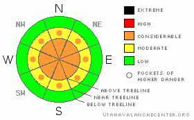
Danger Rose Tutorial
|
The avalanche danger is Level 3 (Considerable) on all aspects at upper & mid elevations due to a combination of a persistent slab, fresh sensitive wind slabs and loose snow avalanches. At lower elevations the avalanche danger is mostly Level 1 (Low). |
|
|
CURRENT CONDITIONS |

|
Monday's warm wet storm wreaked havoc on our snowpack. There is now a nice glaze in the form of a rain crust throughout the range all the way to ridgetop. Remarkably, the surface hoar remained intact at mid & upper elevations. Riding conditions are pretty poor. You're either riding right on the rain crust, or on a few inches of rime snow on top of the rain crust.
It's currently snowing in the heart of the range. Temps are in the low 20's at mid elevation and mid teens at upper elevation with winds out of the SSW. Check out yesterdays observations from both Ted & I here. |
|
|
RECENT ACTIVITY |

|
I was up in the high country yesterday with great visibility. The only avalanche activity I observed was on the east face of Lofty Peak. |
|
|
THREAT #1 |

|
| WHERE |
PROBABILITY |
SIZE |
TREND |
|
|
|
|
| |
|
|
Over the next
12 hours.
|
|
|
Our once solid, forgiving and easy-to-forecast snowpack has taken a 180° turn for the tricky. Here's what Monday's storm did for us: made for some nasty riding conditions, allowed the much talked about surface hoar to remain intact, and created a "bridge" in the form of a rain crust throughout the range.
This bridge is currently keeping our weight off the weaknesses in our snowpack. But, this isn't a modern steel frame bridge. This is the type of bridge you come across on an old de-activated logging road. It's missing a few planks and sagging badly on one side. You might be able to cross it no problem, but your buddy in the F-250 behind you might just push it to the breaking point. Guessing bridge strength is a nasty game, so, that's the reason for the pockets of Considerable hazard. In most places, the bridge is going to keep you from activating the facets, but, in places where the pack is just a bit thinner, i.e. near rock outcroppings, you might just punch through the bridge and trigger a slab avalanche. My advice is to give the big terrain a miss until we've had the opportunity to see how it reacts to a significant amount of water/storm snow. |
|
|
THREAT #2 |

|
| WHERE |
PROBABILITY |
SIZE |
TREND |

|
|
|
|
| |
|
|
Over the next
12 hours.
|
|
|
Here's the thing about rain crusts; they're slippery. It's currently snowing an inch an hour at Trial Lake and the storm is expected to total about 9". Oddly enough, I don't expect the new snow to adhere very well to the existing snow surface. Most of the loose snow avalanches aren't going to be very deep, but, be heads up about gulley bottoms, avalanche runouts and terrain traps where a fast running loose snow avalanche could pack a more serious punch. |
|
|
THREAT #3 |

|
| WHERE |
PROBABILITY |
SIZE |
TREND |

|
|
|
|
| |
|
|
Over the next
12 hours.
|
|
|
Winds are currently out of the S-SW at 30 mph gusting to 40 mph. Combine that with lite density snow, a slippery bed surface and you've got the perfect recipe for sensitive wind slabs. These fresh wind slabs in combination with the persistent slabs are tipping the avalanche class into the unmanageable category. My travel advice is to stick to the lower angle slopes well away from avalanche paths. The problem is that we're not going to get quite enough new snow to make the riding any good in these kinds of places. Be careful that your lust for powder doesn't push you into a dangerous situation. |
|
|
MOUNTAIN WEATHER |

|
Snow will continue to fall through this morning before diminishing this afternoon. Look for a few flurries past sunset. Cold new snow in the mountains combined with clear skies will bring temperatures down to the single digits this evening. Tomorrow looks to be sunny with a high of 25. Thursday night will once again be chilly with a low of 7. Friday brings a chance of snow but right now the models are telling us there isn't much moisture associated with the weekend storm. |
|
|
GENERAL ANNOUNCEMENTS |
The information in this advisory expires 24 hours after the date and time posted, but will be updated by 7:00 AM Saturday Jan. 22nd.
If you’re getting out and about and trigger an avalanche or see anything interesting please drop me an email at craig@utahavalanchecenter.org or call 801-231-2170
Many thanks to all the great folks at Tri-City Performance and Polaris for their extremely generous donation to the Utah Avalanche Center. You guys… and gals rock! Click here to see Craig’s new ride.
The western Uinta advisory program is going full tilt and forecasts will be issued by 7:00 AM on Wednesday, Saturday, Sunday and all holidays. |
|
|
This information does not apply to developed ski areas or highways where avalanche control is normally done. This advisory is from the U.S.D.A. Forest Service, which is solely responsible for its content. This advisory describes general avalanche conditions and local variations always occur. |
|
This advisory provided by the USDA Forest Service, in partnership with:
The Friends of the Utah Avalanche Center, Utah Division of State Parks and Recreation, Utah Division of Emergency Management, Salt Lake County, Salt Lake Unified Fire Authority and the friends of the La Sal Avalanche Center. See our Sponsors Page for a complete list. |
