SPECIAL ANNOUNCEMENT |
 |
Rain on snow is creating unstable conditions below around 8500 feet in elevation. People should avoid all gullies and stay out from under any steep slope to avoid being caught in natural avalanches. At the upper elevations human triggered avalanches are likely especially on slopes approaching 35 degrees in steepness that face north through southeast. |
|
|
BOTTOM LINE
Danger by aspect and elevation on slopes approaching 35° or steeper.
(click HERE for tomorrow's danger rating)
|
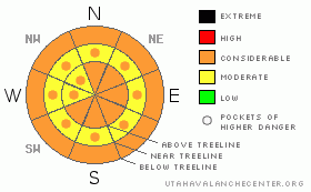
Danger Rose Tutorial
|
In upper elevation terrain, at and above treeline, the avalanche danger is a Level 3 (CONSIDERABLE) and human triggered avalanches are likely, especially on steep wind drifted slopes with an easterly component to their aspect.
Any steep low elevation snow covered slope remains suspect and a Level 3 (CONSIDERABLE) danger exists.
On steep, mid elevation, wind drifted slopes the avalanche danger is a Level 2 (MODERATE) and human triggered avalanches are possible. |
|
|
CURRENT CONDITIONS |

|
A warm, moist, northwesterly flow remains in place over the region. Winds were a little late to arrive, but are making up for lost time and are cranking out of the southwest averaging in the 30’s and 40’s, gusting into the 80’s along the highest ridges. Temperatures are in the mid 30’s and about 4” of very high density snow with .80” of water has dropped out of the sky. The bad news is at nearly all elevations we’ve received some form of rain in the past 24 hours. Riding conditions have certainly taken a turn for the worse. |
|
|
RECENT ACTIVITY |

|
No new avalanche activity to report. Click here for more snow and avalanche observations. |
|
|
THREAT #2 |

|
| WHERE |
PROBABILITY |
SIZE |
TREND |

|
| No probability identified. |
|
|
|
|
|
Low elevation terrain has seen its fair share of rain and wet avalanches are going to be the main avalanche issue. Today you need to avoid steep, rain soaked slopes, especially terrain traps like gullies and road cuts where wet, cement-like debris can stack up very deeply. |
|
|
MOUNTAIN WEATHER |

|
A weak cold front moves through the region early today and snow levels should begin to drop. Additional accumulations aren’t much to write home about, only couple inches are expected. Strong winds gusting into the 60’s and 70’s should begin to mellow out by days end. Temperatures remain warm with highs in the low to mid 30’s. Skies begin to clear late in the day and overnight lows crash into the teens. Partly cloudy skies are on tap for Tuesday with another more winter-like storm moving into the region late in the day with accumulating storm snow expected for Wednesday. |
|
|
GENERAL ANNOUNCEMENTS |
The information in this advisory expires 24 hours after the date and time posted, but will be updated by 7:00 AM on Wednesday Jan. 19th.
If you’re getting out and about and trigger an avalanche or see anything interesting please drop me an email at craig@utahavalanchecenter.org or call 801-231-2170
Many thanks to all the great folks at Tri-City Performance and Polaris for their extremely generous donation to the Utah Avalanche Center. You guys… and gals rock! Click here to see Craig’s new ride.
The western Uinta advisory program is going full tilt and forecasts will be issued by 7:00 AM on Wednesday, Saturday, Sunday and all holidays. |
|
|
This information does not apply to developed ski areas or highways where avalanche control is normally done. This advisory is from the U.S.D.A. Forest Service, which is solely responsible for its content. This advisory describes general avalanche conditions and local variations always occur. |
|
This advisory provided by the USDA Forest Service, in partnership with:
The Friends of the Utah Avalanche Center, Utah Division of State Parks and Recreation, Utah Division of Emergency Management, Salt Lake County, Salt Lake Unified Fire Authority and the friends of the La Sal Avalanche Center. See our Sponsors Page for a complete list. |
