SPECIAL ANNOUNCEMENT |
 |
A Special Avalanche Advisory is in effect for the mountains of northern and central Utah including the western Uintas, Bear River Range, and the Wasatch Plateau. The avalanche danger will be on the rise throughout the Holiday Weekend. Dangerous human triggered avalanches will be likely at mid and upper elevations. Those without excellent avalanche skills should avoid being on or underneath steep snow covered slopes. |
|
|
BOTTOM LINE
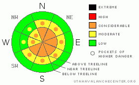
Danger by aspect and elevation on slopes approaching 35° or steeper.
(click HERE for tomorrow's danger rating)
|

Danger Rose Tutorial
|
In upper elevation terrain, at and above treeline, the avalanche danger is a Level 3 (CONSIDERABLE) and human triggered avalanches are likely, especially on steep wind drifted slopes with an easterly component to their aspect.
On steep, mid elevation, wind drifted slopes the avalanche danger is a Level 2 (MODERATE) and human triggered avalanches are possible.
Low elevation terrain has a Level 1 (LOW) avalanche danger. |
|
|
CURRENT CONDITIONS |

|
Under mostly cloudy skies, light snow is falling, temperatures are in the mid to upper 20’s, and westerly winds are starting to get a little burly, gusting into the 30’s along the ridges. Riding and turning conditions are a mixed bag and your best bet is to find wind sheltered terrain off the beaten track. |
|
|
RECENT ACTIVITY |

|
Both natural and human triggered soft slabs along upper elevation ridges have been reported this week. Most of these pockety slides are 12”-18” deep and around 100’ feet wide. Click here for more snow and avalanche observations. |
|
|
THREAT #1 |

|
| WHERE |
PROBABILITY |
SIZE |
TREND |

|
|
|
|
| |
|
|
Over the next
24 hours.
|
|
|
We’ve had a relatively easy go at it the past few weeks with predictable and straightforward avalanche conditions. Sure we’ve got plenty of weak near surface facets and buried surface hoar, and we even have a bed surface. But until now we’ve been missing the main ingredient…. a cohesive slab. Today’s warm dense snow, coupled with strong sustained winds will be perfect for building a slab and all the players are coming together. What’s making things particularly tricky is the buried weak layer. We don’t deal with a whole lot of surface hoar in Utah because it’s usually destroyed by wind or warm temperatures. Now that it’s buried and preserved we’ve got an unusual situation in our snowpack. Remember- unusual snowpack conditions lead to unusual avalanches. Today’s avalanches will start to break wider than you might expect, have the potential to break after several riders have been on the slope, and can also run on lower angle slopes. We’re in for a couple of tricky days and you’ll need to be on your toes if you’re headed to the mountains. As the new snow piles up and the winds continue to increase, avalanche conditions will become less predictable. Today you need to avoid steep wind drifted slopes and avalanche run out zones. In addition, even if you’re playing it safe on low angle terrain, think about steep slopes above and adjacent to where you’re riding. |
|
|
MOUNTAIN WEATHER |

|
A moist and relatively warm, northwest flow influences our weather the next couple of days. The big news is the wind. West and northwest winds will begin to crank especially late today and into this evening. Averaging 30-40 mph today, winds should be nuking into the 60’s and 70’s tonight into Monday morning. We should see periods of snow today through tonight with accumulations in the 4”-8” range by morning. Temperatures remain mild with highs reaching into the low 30’s. Overnight lows dip into the mid 20’s. Some type of break in the action occurs late Monday with a better looking and more organized cold front on tap for late Tuesday into Wednesday. |
|
|
GENERAL ANNOUNCEMENTS |
The information in this advisory expires 24 hours after the date and time posted, but will be updated by 7:00 AM on Monday Jan. 17th with a holiday advisory.
If you’re getting out and about and trigger an avalanche or see anything interesting please drop me an email at craig@utahavalanchecenter.org or call 801-231-2170
Many thanks to all the great folks at Tri-City Performance and Polaris for their extremely generous donation to the Utah Avalanche Center. You guys… and gals rock! Click here to see Craig’s new ride.
The western Uinta advisory program is going full tilt and forecasts will be issued by 7:00 AM on Wednesday, Saturday, Sunday and all holidays. |
|
|
This information does not apply to developed ski areas or highways where avalanche control is normally done. This advisory is from the U.S.D.A. Forest Service, which is solely responsible for its content. This advisory describes general avalanche conditions and local variations always occur. |
|
This advisory provided by the USDA Forest Service, in partnership with:
The Friends of the Utah Avalanche Center, Utah Division of State Parks and Recreation, Utah Division of Emergency Management, Salt Lake County, Salt Lake Unified Fire Authority and the friends of the La Sal Avalanche Center. See our Sponsors Page for a complete list. |


