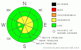
BOTTOM LINE
Danger by aspect and elevation on slopes approaching 35° or steeper.
(click HERE for tomorrow's danger rating)
|
Danger Rose Tutorial
|
In the wind zone at and above treeline, a Level 2 (MODERATE) avalanche danger exists and human triggered avalanches are possible on steep slopes with recent deposits of wind drifted snow.
All other areas have a mostly Level 1 (LOW) avalanche danger. |
|
|
CURRENT CONDITIONS |

|
Skies are mostly cloudy, light snow is falling, and temperatures are in the mid to upper 20’s. West and northwest winds have mellowed somewhat from yesterday’s gusts in the 30’s to a less obnoxious 10-15 mph. along the high ridges. A few inches of dense snow fell on Thursday, but it wasn’t quite enough to fill in the old frozen tracks, which now feel like curb and gutter under our machines. However, riding and turning conditions remain quite good, especially in wind sheltered terrain off the beaten track. |
|
|
RECENT ACTIVITY |

|
Both natural and human triggered soft slabs along upper elevation ridges have been reported the past few days. Most of these pockety slides are 12”-18” deep, around 100’ feet wide and not running too far. Click here for more snow and avalanche observations. |
|
|
THREAT #1 |

|
| WHERE |
PROBABILITY |
SIZE |
TREND |
|
|
|
|
| |
|
|
Over the next
24 hours.
|
|
|
Yesterday’s brisk ridgetop winds, combined with a little bit of dense new snow, continued to create slabs along the leeward side of upper elevation ridges. By days end these fresh wind drifts were sensitive to our additional weight and they were starting to get stiffer, breaking wider than you might expect. Buried surface hoar and near surface facets are the culprit weak layer. While predictably well behaved at the moment, as a slab builds on top of these notoriously persistent, tricky, weak layers we’ll have to keep a close eye on them and see how they’re adjusting. Today, slabs sensitive to the additional weight of a rider are isolated to our highest terrain. Mostly manageable in size and easy to detect by their smooth, rounded and often hollow sound, I’d continue to avoid any steep wind drifted slope today. In addition, cornices are growing and may break further back than you’d anticipate.
When the avalanche danger is low to moderate, folks tend to push themselves into bigger more extreme terrain. Remember- low danger doesn't mean no danger, and you can certainly go out and trigger an avalanche today. Be sure to take your avalanche rescue gear (beacon, shovel, and probe) and know how to use it. If you’re getting into steep, radical or technical terrain today, think about the consequences of triggering even a small slide and have an escape route planned. |
|
|
MOUNTAIN WEATHER |

|
A weak storm bumps to our north today, giving us partly to mostly cloudy skies and a snow flurry or two. High temperatures reach into the low to mid 30’s with overnight lows dipping into the teens. Northwest winds remain in the 10-20 mph range, increasing late in the day and overnight as a cold front slides into the region. Gusty northwest winds and snow are on tap for Sunday with accumulations in the 2”-4” range. Snow continues into early Monday and then a better looking storm develops for the region on Wednesday. |
|
|
GENERAL ANNOUNCEMENTS |
The information in this advisory expires 24 hours after the date and time posted, but will be updated by 7:00 AM on Sunday Jan. 16th.
If you’re getting out and about and trigger an avalanche or see anything interesting please drop me an email at craig@utahavalanchecenter.org or call 801-231-2170
Many thanks to all the great folks at Tri-City Performance and Polaris for their extremely generous donation to the Utah Avalanche Center. You guys… and gals rock! Click here to see Craig’s new ride.
The western Uinta advisory program is going full tilt and forecasts will be issued by 7:00 AM on Wednesday, Saturday, Sunday and all holidays. |
|
|
This information does not apply to developed ski areas or highways where avalanche control is normally done. This advisory is from the U.S.D.A. Forest Service, which is solely responsible for its content. This advisory describes general avalanche conditions and local variations always occur. |
|
This advisory provided by the USDA Forest Service, in partnership with:
The Friends of the Utah Avalanche Center, Utah Division of State Parks and Recreation, Utah Division of Emergency Management, Salt Lake County, Salt Lake Unified Fire Authority and the friends of the La Sal Avalanche Center. See our Sponsors Page for a complete list. |
