BOTTOM LINE
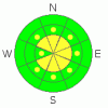
Danger by aspect and elevation on slopes approaching 35° or steeper.
(click HERE for tomorrow's danger rating)
|

Danger Rose Tutorial
|
Fresh windslabs exist just below ridge top making for a Level 2 (Moderate) avalanche danger above treeline. All other areas have a mostly Level 1 (Low) avalanche danger. |
|
|
CURRENT CONDITIONS |

|
The mercury is hovering right around 12 F this morning with consistent winds out of the SW at 20 mph under mostly cloudy skies. It's been almost two weeks since our last significant storm which means two things;
a. finding good riding conditions is becoming a bit more of a challenge. Your best bet is un-tracked terrain at mid & upper elevations that is protected from the wind & out of the sun.
more importantly;
b. the snow surface has essentially been rotting in the cold temperatures. A combination of surface hoar & near surface facets (read: very weak snow) is well preserved underneath a few inches of snow from the weekend. While not an issue right now, we are looking at potentially scary avalanche conditions when it starts storming again. While it's not from our zone, check out Brett Kobernik's great tutorial on the current snow surface. (Conditions in the Uintas are almost exactly the same.) |
|
|
RECENT ACTIVITY |

|
Ted found a few wind slabs just off the ridges yesterday along with some sluffing of the new snow, but, these have mostly been small manageable avalanches. Check out great observations submitted yesterday by both Ted & Reid. |
|
|
THREAT #1 |

|
| WHERE |
PROBABILITY |
SIZE |
TREND |
|
|
|
|
| |
|
|
Over the next
24 hours.
|
|
|
Sustained S-SW winds formed scattered wind slabs just below ridge top yesterday, the deepest of which are in the 12 - 18" range. But, this should be a very manageable hazard. Ride defensively by throwing a slope cut or two in any slope you plan to play on. Be aware of the consequences of a slide. If a foot deep wind slab pops out on an open slope its likely not a big deal if you're on your machine. But if said slab washes you through trees or takes you over a rock band, that's a different story. |
|
|
THREAT #2 |

|
| WHERE |
PROBABILITY |
SIZE |
TREND |

|
|
|
|
| |
|
|
Over the next
24
hours.
|
|
|
When the forecasted danger is low/moderate, folks tend to push themselves into bigger more extreme terrain. While the danger today is mostly low, be aware that low danger doesn't mean no danger, and you can certainly go out and trigger an avalanche today. Be sure to take your avalanche rescue gear (beacon, shovel & probe) & continue to use proper protocol. No more than one person on a slope at a time, remaining riders turn their machines away from the slope and watch the rider on the slope carefully. |
|
|
MOUNTAIN WEATHER |

|
A weak split system is currently passing over the forecast area, but it won't produce much more than clouds. Temperatures should jump into the low 20's before the sun sets this evening. Tomorrow brings more of the same with another weak storm making its way across Utah Thursday evening. It will bring snow showers, but we're only expecting a few inches. Northwest flow settles over the area through the weekend and into next week. While it's not a particularly strong system, it will have multiple waves that could stack up enough to improve riding conditions. |
|
|
GENERAL ANNOUNCEMENTS |
The information in this advisory expires 24 hours after the date and time posted, but will be updated by 7:00 AM on Saturday Jan. 15th.
If you’re getting out and about and trigger an avalanche or see anything interesting please drop me an email at craig@utahavalanchecenter.org or call 801-231-2170
Many thanks to all the great folks at Tri-City Performance and Polaris for their extremely generous donation to the Utah Avalanche Center. You guys… and gals rock! Click here to see Craig’s new ride.
The western Uinta advisory program is going full tilt and forecasts will be issued by 7:00 AM on Wednesday, Saturday, Sunday and all holidays. |
|
|
This information does not apply to developed ski areas or highways where avalanche control is normally done. This advisory is from the U.S.D.A. Forest Service, which is solely responsible for its content. This advisory describes general avalanche conditions and local variations always occur. |
|
This advisory provided by the USDA Forest Service, in partnership with:
The Friends of the Utah Avalanche Center, Utah Division of State Parks and Recreation, Utah Division of Emergency Management, Salt Lake County, Salt Lake Unified Fire Authority and the friends of the La Sal Avalanche Center. See our Sponsors Page for a complete list. |
