SPECIAL ANNOUNCEMENT |
 |
We still have a few open slots left in our Avy Essentials Class for Sledders. The Evening class is TONIGHT Wednesday Jan. 5th followed by an on-the-snow field session Saturday 8th. Click here for more details and to register.
We've installed state of the art Backcountry Access Beacon Checkers designed specifically for snowmobilers at both the Noblets & Soapstone trailheads. Check 'em out. |
|
|
BOTTOM LINE
Danger by aspect and elevation on slopes approaching 35° or steeper.
(click HERE for tomorrow's danger rating)
|

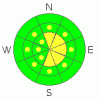
Danger Rose Tutorial
|
In steep, rocky, upper elevation terrain a Level 2 (MODERATE) avalanche danger exists; while natural avalanches are unlikely, large destructive human triggered avalanches are possible in isolated areas.
In all other upper & mid elevation terrain, the avalanche danger is Level 2 (MODERATE) and human triggered avalanches are possible on steep, wind drifted slopes.
At lower elevations and in non wind affected terrain the avalanche danger is Level 1 (LOW). |
|
|
CURRENT CONDITIONS |

|
Temperatures are a bit inverted this morning. Low elevation temps are hovering in the single digits while mid & high elevation temps are in the low teens. Winds have picked up out of the WNW and are now steady at 25 mph, gusting as high as 40 mph. Upper elevation slopes have taken a beating from all the wind, but powder can still be found on shady & protected mid elevation slopes. |
|
|
RECENT ACTIVITY |

|
Ted found a few small wind slab avalanches yesterday. Other than that, it feels pretty quiet at the moment. Cold temperatures have driven faceting at the snow surface & while this isn't an issue at the moment, it could be a player once buried by this weekends system.
Click here for recent snowpack and avalanche observations. |
|
|
THREAT #1 |

|
| WHERE |
PROBABILITY |
SIZE |
TREND |
|
|
|
|
| |
|
|
Over the next
24 hours.
|
|
|
Upper elevation slopes in the wind zone harbor a collection of wind slabs, some are sensitive, but most of them are pretty stubborn. While winds have been slowly increasing the last 24 hours, I suspect there isn't a whole lot of snow available for transport. None the less, be on your "A-game" if your travels take you into mid & upper elevation slopes exposed to the wind; tweak small test slopes & use slope cuts to decide which slopes you feel comfortable playing on. |
|
|
THREAT #2 |

|
| WHERE |
PROBABILITY |
SIZE |
TREND |
|
|
|
|
| |
|
|
Over the next
24 hours.
|
|
|
For the most part the snowpack feels incredible. It's deep, warm & pretty solid throughout most of the range. But, the Uintas are a very big place, and I'm not quite ready to stop thinking about the potential for large, destructive deep slab avalanches. This avalanche problem is limited to steep, rocky areas where the snowpack is thin. Places like this. Be very careful in big terrain today. You don't want one of these monster avalanches to surprise you.
|
|
|
MOUNTAIN WEATHER |

|
Today will be mostly cloudy with a high near 21. There is a 30% chance of snow after 11 am as a weak storm trickles down the Rockies, but total snowfall of less than one inch is expected. Thursday and Friday look to be partly sunny before a more robust cold front moves into northern Utah over the weekend. The models conflict on snow totals at this point, but it should be more than enough to freshen up tracked up slopes. |
|
|
GENERAL ANNOUNCEMENTS |
The information in this advisory expires 24 hours after the date and time posted, but will be updated by 7:00 AM on Saturday Jan. 8th.
If you’re getting out and about and trigger an avalanche or see anything interesting please drop me an email at craig@utahavalanchecenter.org or call 801-231-2170
We are teaching a Snowmobile Avalanche Awareness Course the week of January 5th. Click here for details.
Also, now is a great time to schedule one of our free avalanche awareness presentations for your group or club. Email or call me and we’ll get you booked before things get too crazy.
Many thanks to all the great folks at Tri-City Performance and Polaris for their extremely generous donation to the Utah Avalanche Center. You guys… and gals rock! Click here to see Craig’s new ride.
The western Uinta advisory program is going full tilt and forecasts will be issued by 7:00 AM on Wednesday, Saturday, Sunday and all holidays. |
|
|
This information does not apply to developed ski areas or highways where avalanche control is normally done. This advisory is from the U.S.D.A. Forest Service, which is solely responsible for its content. This advisory describes general avalanche conditions and local variations always occur. |
|
This advisory provided by the USDA Forest Service, in partnership with:
The Friends of the Utah Avalanche Center, Utah Division of State Parks and Recreation, Utah Division of Emergency Management, Salt Lake County, Salt Lake Unified Fire Authority and the friends of the La Sal Avalanche Center. See our Sponsors Page for a complete list. |
