SPECIAL ANNOUNCEMENT |
 |
What a great way to start off the New Year! We still have a few open slots left for next weeks Avy Essentials Class for Sledders. Evening class is Wednesday Jan. 5th followed by an on-the-snow field session Saturday 8th. Click here for more details and to register. |
|
|
BOTTOM LINE
Danger by aspect and elevation on slopes approaching 35° or steeper.
(click HERE for tomorrow's danger rating)
|
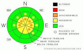
Danger Rose Tutorial
|
In the wind zone it’s an entirely different world and the potential for deep, dangerous avalanches that break to the ground still exists. Steep, rocky, high elevation terrain should be regarded as suspect and a Level 3 (CONSIDERABLE) avalanche danger will be found on slopes with these characteristics.
In mid elevation terrain, the avalanche danger is a Level 2 (MODERATE) and human triggered avalanches are possible on steep, wind drifted slopes.
At lower elevations and in non wind affected terrain the avalanche danger is a Level 1 (LOW). |
|
|
CURRENT CONDITIONS |

|
Some high clouds moved over the region late last night, helping moderate temperatures which are currently near zero. Winds switched to the southwest yesterday afternoon and they’ve been blowing 20-30 mph along the high ridges. Upper elevation terrain is a bit wind worked, but excellent dry, cold powder conditions will still be found in mid elevation wind sheltered terrain. |
|
|
RECENT ACTIVITY |

|
Yesterday, I found a few shallow wind slabs on the leeward side of upper elevation ridges that averaged about a foot deep.
Click here for recent snowpack and avalanche observations. |
|
|
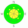
THREAT #1 |

|
| WHERE |
PROBABILITY |
SIZE |
TREND |
|
|
|
|
| |
|
|
Over the next
24 hours.
|
|
|
A few lingering wind slabs along the upper elevation ridgelines may still be sensitive today, but these will be manageably breaking at or below your skis, board, or sled. While the shallow slabs aren’t packing too much of a punch, take care one doesn’t catch you off guard and slam you into a group of trees. Before dropping off a ridge, gather some information by tweaking small test slopes and using slope cuts. |
|
|
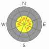
THREAT #2 |

|
| WHERE |
PROBABILITY |
SIZE |
TREND |
|
|
|
|
| |
|
|
Over the next
24 hours.
|
|
|
In most terrain the snow is becoming homogenous, feels solid, and is on the road to becoming one of the best snowpack’s we’ve seen in quite some time. For the most part it’s bomber and easy to get lulled into a false sense of security and let our guard down. We start getting into more technical terrain and look at slopes with our riding eyeballs rather than our avalanche eyeballs…. big difference. If you want to get into steep terrain today, especially places that you haven’t visited for a while, you’re gonna need to spend some time figuring out what the snowpack is doing. While the chances of triggering deep, scary avalanches is diminishing, problem is if you do trigger a slide that breaks deep in the pack it’ll be a dangerous avalanche. That being said- start off small and get some information about slopes on similar elevations, aspect, and slope angle to what you want to ride and see how they’re reacting. If you’re center punching steep terrain without some type of snow stability testing you’re riding blind and you’re going to get surprised.
This is a great example of a location capable of producing a large full depth avalanche. |
|
|
MOUNTAIN WEATHER |

|
Morning clouds will dissolve giving way to partly cloudy skies before a weak storm brushes the region late tonight giving us an inch or two of new snow by morning. Southwest winds become a bit gusty near the high ridges, blowing into the 30’s and 40’s. Temperatures reach into the low 20’s before diving back to the single digits overnight. Another weak system affects the region mid week followed by strong high pressure and quiet weather into next weekend. |
|
|
GENERAL ANNOUNCEMENTS |
The information in this advisory expires 24 hours after the date and time posted, but will be updated by 7:00 AM on Wednesday Jan. 5th.
If you’re getting out and about and trigger an avalanche or see anything interesting please drop me an email at craig@utahavalanchecenter.org or call 801-231-2170
We are teaching a Snowmobile Avalanche Awareness Course the week of January 5th. Click here for details.
Also, now is a great time to schedule one of our free avalanche awareness presentations for your group or club. Email or call me and we’ll get you booked before things get too crazy.
Many thanks to all the great folks at Tri-City Performance and Polaris for their extremely generous donation to the Utah Avalanche Center. You guys… and gals rock! Click here to see Craig’s new ride.
The western Uinta advisory program is going full tilt and forecasts will be issued by 7:00 AM on Wednesday, Saturday, Sunday and all holidays. |
|
|
This information does not apply to developed ski areas or highways where avalanche control is normally done. This advisory is from the U.S.D.A. Forest Service, which is solely responsible for its content. This advisory describes general avalanche conditions and local variations always occur. |
|
This advisory provided by the USDA Forest Service, in partnership with:
The Friends of the Utah Avalanche Center, Utah Division of State Parks and Recreation, Utah Division of Emergency Management, Salt Lake County, Salt Lake Unified Fire Authority and the friends of the La Sal Avalanche Center. See our Sponsors Page for a complete list. |
