SPECIAL ANNOUNCEMENT |
 |
What a great way to start off the New Year! We still have a few open slots left for next weeks Avy Essentials Class for Sledders. Evening class is Wednesday Jan. 5th followed by an on-the-snow field session Saturday 8th. Click here for more details and to register. |
|
|
BOTTOM LINE
Danger by aspect and elevation on slopes approaching 35° or steeper.
(click HERE for tomorrow's danger rating)
|
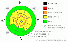
Danger Rose Tutorial
|
Above treeline pockets of Level 3 (CONSIDERABLE) danger exist and human triggered avalanches are likely, especially on steep, wind drifted slopes.
In steep, rocky terrain, especially in the wind zone along the high elevation wind exposed ridges and peaks, the potential for deep, dangerous avalanches that break to the ground still exists. A Level 3 (CONSIDERABLE) avalanche danger will be found in terrain with these characteristics.
In mid elevation terrain, the avalanche danger is a Level 2 (MODERATE) and human triggered avalanches are possible on steep, wind drifted slopes.
At lower elevations and in non wind effected terrain the avalanche danger is a Level 1 (LOW). |
|
|
CURRENT CONDITIONS |

|
Happy New Year! As the big midweek storm system shifts to the east, clear skies and very cold temperatures are left in its wake. Across the range it’s right around -16 degrees and with a west wind along the ridges blowing 15-25 mph it’ll feel like -41 degrees. Deep powder riding will be found in mid elevation wind sheltered slopes, though the cold temperatures are making the snow feel slow and stiff. |
|
|
RECENT ACTIVITY |

|
We haven’t been able to see a thing for days. Hopefully today’s good visibility sheds some light on recent avalanche activity.On Tuesday Ted & Grant found a large avalanche in an area we call "the playground," a north facing slope on the backside of Bald Mountain.
Click here for recent snowpack and avalanche observations. |
|
|
THREAT #1 |

|
| WHERE |
PROBABILITY |
SIZE |
TREND |
|
|
|
|
| |
|
|
Over the next
24 hours.
|
|
|
A few wind drifts linger along the leeward side of upper elevation ridges and these may still be sensitive to the additional weight of a rider. While generally manageable in size, there could be a slab or two that’s big enough to knock you off your feet or sled and take you for an unexpected ride. Play it safe today and avoid any steep wind drifted slope. |
|
|
THREAT #2 |

|
| WHERE |
PROBABILITY |
SIZE |
TREND |

|
|
|
|
| |
|
|
Over the next
24 hours.
|
|
|
We’re at a cross roads in the life of our snowpack. As the snow settles and becomes stronger, it’ll feel bomber under our sled, skis or board and we’ll be able to ride into steeper terrain and feel pretty solid about the snowpack. Sure it’s gaining strength and deep avalanches are getting harder to trigger. However, if you go hunting today you’re apt to find something large and unexpected, especially on slopes where a strong slab rests on weak snow. If your travels take you into steep, complicated, or technical terrain today, particularly at upper elevations, think about the consequences of triggering a slide. Once initiated, today’s avalanches have the possibility of breaking into deeper buried weak layers of snow creating a large and dangerous avalanche.
This is a great example of a location capable of producing a large full depth avalanche. |
|
|
MOUNTAIN WEATHER |

|
Mostly sunny skies should take some of the edge off, but it’ll be cold none-the-less with highs only reaching into the single digits. Overnight lows dip into negative territory once again. Winds remain light and well behaved, with a few gusts in the 20’s along the high ridges. A weak brush by on Sunday offers a few more clouds and warming temperatures with highs in the low 20’s. |
|
|
GENERAL ANNOUNCEMENTS |
The information in this advisory expires 24 hours after the date and time posted, but will be updated by 7:00 AM on Sunday Jan. 2nd.
If you’re getting out and about and trigger an avalanche or see anything interesting please drop me an email at craig@utahavalanchecenter.org or call 801-231-2170
We are teaching a Snowmobile Avalanche Awareness Course the week of January 5th. Click here for details.
Also, now is a great time to schedule one of our free avalanche awareness presentations for your group or club. Email or call me and we’ll get you booked before things get too crazy.
Many thanks to all the great folks at Tri-City Performance and Polaris for their extremely generous donation to the Utah Avalanche Center. You guys… and gals rock! Click here to see Craig’s new ride.
The western Uinta advisory program is going full tilt and forecasts will be issued by 7:00 AM on Wednesday, Saturday, Sunday and all holidays. |
|
|
This information does not apply to developed ski areas or highways where avalanche control is normally done. This advisory is from the U.S.D.A. Forest Service, which is solely responsible for its content. This advisory describes general avalanche conditions and local variations always occur. |
|
This advisory provided by the USDA Forest Service, in partnership with:
The Friends of the Utah Avalanche Center, Utah Division of State Parks and Recreation, Utah Division of Emergency Management, Salt Lake County, Salt Lake Unified Fire Authority and the friends of the La Sal Avalanche Center. See our Sponsors Page for a complete list. |
