SPECIAL ANNOUNCEMENT |
 |
We still have a few open slots left for next weeks Avy Essentials Class for Sledders. Evening class is Wednesday Jan. 5th followed by an on-the-snow field session Saturday 8th. Click here for more details and to register. |
|
|
BOTTOM LINE
Danger by aspect and elevation on slopes approaching 35° or steeper.
(click HERE for tomorrow's danger rating)
|
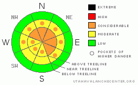
Danger Rose Tutorial
|
Above treeline pockets of Level 3 (CONSIDERABLE) danger exist and human triggered avalanches are likely, especially on steep, wind drifted slopes.
In steep, rocky terrain, especially in the wind zone along the high elevation wind exposed ridges and peaks, the potential for deep, dangerous avalanches that break to the ground still exists. A Level 3 (CONSIDERABLE) avalanche danger will be found in terrain with these characteristics.
In mid elevation terrain, the avalanche danger is a Level 2 (MODERATE) and human triggered avalanches are possible on steep, wind drifted slopes.
At lower elevations out of the wind the avalanche danger is a Level 1 (LOW). |
|
|
CURRENT CONDITIONS |

|
Light snow continues to fall as the cold core of the mid week storm system pulls out of the region. Hope you plugged the block heater in, because man is it cold out there this morning. Current trailhead temperatures are right around -2 degrees and it’s -10 at 10,000’. Factor in northwest winds blowing 15-20 mph along the ridges and it’s a brutal -33 degrees. Recent winds worked the upper elevations, but you’ll still find light, cold smoke, especially in wind sheltered mid elevation terrain. |
|
|
RECENT ACTIVITY |

|
A low cloud deck kept visibility to a minimum and we couldn't see a thing yesterday. On Tuesday Ted & Grant found a large avalanche in an area we call "the playground," a north facing slope on the backside of Bald Mountain.
Click here for recent snowpack and avalanche observations. |
|
|
THREAT #1 |

|
| WHERE |
PROBABILITY |
SIZE |
TREND |
|
|
|
|
| |
|
|
Over the next
24 hours.
|
|
|
Winds have been all over the place the past few days and there are still a few lingering wind slabs that’ll be found along upper elevation ridges and around terrain features like chutes and gullies. While mostly manageable in size and locked in place by the cold temperatures, there may be a drift or two that remains sensitive to the additional weight of a rider. Today you’ll want to look for and avoid any fresh wind drift. They’ll be rounded, pillow-like, and may even have a hollow sound to them. |
|
|
THREAT #2 |

|
| WHERE |
PROBABILITY |
SIZE |
TREND |
|
|
|
|
| |
|
|
Over the next
24 hours.
|
|
|
Not much has changed from this camp and we're not ready to close the books on the deep slab danger just yet. We just added a significant amount of water weight to our snowpack and while most of the range's avalanche problems are confined to the new snow, there are places in the Uintas where you can trigger a deep, dangerous avalanche. You know the drill here… it’s our usual suspects- steep slopes that are thin, exposed and rocky. In perimeter terrain to the east and south where the snowpack is a bit shallower and weaker, the avalanche danger may be more pronounced.This is a great example of a location capable of producing a large full depth avalanche. |
|
|
MOUNTAIN WEATHER |

|
Off and on snow showers are slated for most of the day, but accumulations should be on the light side. West and northwest winds blow 15-25 mph with a gust or two in the low 30’s along the highest peaks. High temperatures struggle to get out of negative territory, before crashing again tonight to near -15 degrees. High pressure and a slow warming trend are on tap for the weekend. |
|
|
GENERAL ANNOUNCEMENTS |
The information in this advisory expires 24 hours after the date and time posted, but will be updated by 7:00 AM on Saturday Jan. 1st.
If you’re getting out and about and trigger an avalanche or see anything interesting please drop me an email at craig@utahavalanchecenter.org or call 801-231-2170
We are teaching a Snowmobile Avalanche Awareness Course the week of January 5th. Click here for details.
Also, now is a great time to schedule one of our free avalanche awareness presentations for your group or club. Email or call me and we’ll get you booked before things get too crazy.
Many thanks to all the great folks at Tri-City Performance and Polaris for their extremely generous donation to the Utah Avalanche Center. You guys… and gals rock! Click here to see Craig’s new ride.
The western Uinta advisory program is going full tilt and forecasts will be issued by 7:00 AM on Wednesday, Saturday, Sunday and all holidays. |
|
|
This information does not apply to developed ski areas or highways where avalanche control is normally done. This advisory is from the U.S.D.A. Forest Service, which is solely responsible for its content. This advisory describes general avalanche conditions and local variations always occur. |
|
This advisory provided by the USDA Forest Service, in partnership with:
The Friends of the Utah Avalanche Center, Utah Division of State Parks and Recreation, Utah Division of Emergency Management, Salt Lake County, Salt Lake Unified Fire Authority and the friends of the La Sal Avalanche Center. See our Sponsors Page for a complete list. |
