AVALANCHE WARNING »
Dangerous avalanche conditions are occuring or are imminent.
Backcountry travel in avalanche terrain is not recommended.
|
 |
Notice: An Avalanche Warning is in effect for the mountains of Northern Utah including the Bear River Range, Western Uintas, Wasatch Plateau and Wasatch Mountains. Strong winds & heavy snowfall have created dangerous avalanche conditions and human triggered avalanches are likely. Backcountry travelers need excellent terrain and snow pack evaluation skills and should avoid steep wind drifted slopes and avalanche run out zones. |
|
|
BOTTOM LINE
Danger by aspect and elevation on slopes approaching 35° or steeper.
(click HERE for tomorrow's danger rating)
|
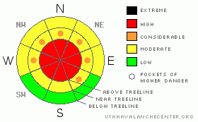
Danger Rose Tutorial
|
In steep upper elevation wind drifted terrain the avalanche danger is a Level 3 (CONSIDERABLE) and human triggered avalanches are likely. Be aware that pockets of Level 4 (HIGH) avalanche danger are present in the wind zone along the high elevation wind exposed ridges and peaks.
In steep, rocky, upper elevation terrain the potential for deep, dangerous avalanches that break to the ground still exists. A Level 3 (CONSIDERABLE) avalanche danger will be found in terrain with these characteristics.
In mid elevation terrain, the avalanche danger is a Level 2 (MODERATE) and human triggered avalanches are possible on steep, wind drifted slopes. |
|
|
CURRENT CONDITIONS |

|
Yet another great storm for the eastern front! The southern half of the range near Daniels got slammed during the pre-frontal portion of the storm, receiving 30” of snow with 2.6” of water. The further you travel into the interior of the range totals are slightly less, but impressive none-the-less. Trial Lake, Chalk Creek and Hayden all register around 2’ of new snow. Winds turned to the west around 8:00 last night, blowing into the 30’s, before turning northwest early this morning and dying off into the low 20’s. Temperatures crashed as well and currently it’s right around 2 degrees at 10,000’ and 8 degrees at the trailheads. Wind chill will factor into today’s equation, especially along the ridges where it’s right around -30 degrees. It’ll be wallowfest out there today, especially in the southern half of the range where impressive new snow totals are nearing three feet. |
|
|
RECENT ACTIVITY |

|
Raging winds kept visibility to a minimum and we couldn't see a thing yesterday. On Tuesday Ted & Grant found a large avalanche in an area we call "the playground," a north facing slope on the backside of Bald Mountain.
Click here for recent snowpack and avalanche observations. |
|
|
THREAT #1 |

|
| WHERE |
PROBABILITY |
SIZE |
TREND |
|
|
|
|
| |
|
|
Over the next
24 hours.
|
|
|
Winds have been all over the place the past 24 hours, blasting into the 60’s and 70’s, forming dangerous slabs along the leeward side of upper elevation ridges and lower down slope than usual. Today’s slabs may be a little more stubborn than yesterday and harder to detect because now their covered over with light fluffy snow. In any case, drifts can still be triggered by the weight of a rider. Once initiated, they’ll be several feet deep and have the possibility of breaking into weaker layers in the mid portion of our snowpack. Today, you’ll want to look for and avoid any steep, wind drifted slope. |
|
|
THREAT #2 |

|
| WHERE |
PROBABILITY |
SIZE |
TREND |
|
|
|
|
| |
|
|
Over the next
48 hours.
|
|
|
We're not ready to close the books on the deep slab danger just yet. We just added a significant amount of water weight to our snowpack and while most of the range's avalanche problems are confined to the new snow, there are places in the Uintas where you can trigger a deep, dangerous avalanche. You know the drill here… it’s our usual suspects- steep slopes that are thin, exposed and rocky. In perimeter terrain to the east and south where the snowpack is a bit shallower and weaker, the avalanche danger may be more pronounced.This is a great example of a location capable of producing a large full depth avalanche. |
|
|
MOUNTAIN WEATHER |

|
Snow showers linger for the morning and we may see a couple more inches of light fluff before the end of the day. Northwesterly winds blow in the 20’s along the ridges and high temperatures barely creep out of the single digits with overnight lows right around -10 degrees. An east-southeast flow develops late today and that may usher in yet another band of snow. A few more snow showers are on tap for early Friday before high pressure builds for the weekend. |
|
|
GENERAL ANNOUNCEMENTS |
The information in this advisory expires 24 hours after the date and time posted, but will be updated by 7:00 AM with a holiday forecast on Friday Dec. 31st.
If you’re getting out and about and trigger an avalanche or see anything interesting please drop me an email at craig@utahavalanchecenter.org or call 801-231-2170
We are teaching a Snowmobile Avalanche Awareness Course the week of January 5th. Click here for details.
Also, now is a great time to schedule one of our free avalanche awareness presentations for your group or club. Email or call me and we’ll get you booked before things get too crazy.
Many thanks to all the great folks at Tri-City Performance and Polaris for their extremely generous donation to the Utah Avalanche Center. You guys… and gals rock! Click here to see Craig’s new ride.
The western Uinta advisory program is going full tilt and forecasts will be issued by 7:00 AM on Wednesday, Saturday, Sunday and all holidays. |
|
|
This information does not apply to developed ski areas or highways where avalanche control is normally done. This advisory is from the U.S.D.A. Forest Service, which is solely responsible for its content. This advisory describes general avalanche conditions and local variations always occur. |
|
This advisory provided by the USDA Forest Service, in partnership with:
The Friends of the Utah Avalanche Center, Utah Division of State Parks and Recreation, Utah Division of Emergency Management, Salt Lake County, Salt Lake Unified Fire Authority and the friends of the La Sal Avalanche Center. See our Sponsors Page for a complete list. |
