AVALANCHE WATCH »
The risk of an avalanche is expected to increase significantly
but the timing and location are still uncertain. Stay tuned for updates.
|
 |
Notice: This Avalanche Watch is for the mountains of Northern Utah including the Bear River Range, Western Uintas, Wasatch Plateau and Wasatch Mountains. Strong winds & heavy snowfall will create an increasing avalanche danger today through Thursday. Both human triggered and natural avalanches are possible. Backcountry travelers need excellent terrain and snow pack evaluation skills and should avoid steep slopes and avalanche run out zones. |
|
|
BOTTOM LINE
Danger by aspect and elevation on slopes approaching 35° or steeper.
(click HERE for tomorrow's danger rating)
|
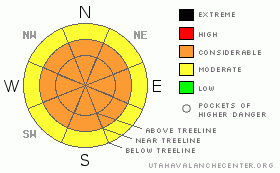
Danger Rose Tutorial
|
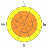
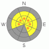
Today is a day of increasing avalanche danger. This morning the avalanche danger is Level 2 (Moderate) due to a few lingering wind slabs. As the storm system intensifies after lunch the avalanche danger will quickly increase to Level 3 (Considerable) due to new snow deposits and fresh sensitive wind slabs on all aspects at both mid & high elevations. This hazard will continue to build into Thursday.
In steep, rocky exposed areas there is potential for full depth avalanches. A Level 3 (Considerable) avalanche danger exits in terrain with these characteristics. |
|
|
CURRENT CONDITIONS |

|
It's in the mid teens across the range this morning. Ridge top winds are strong out of the S-SE, gusting as high as 70 mph as a moist pacific storm streams into our area. Riding conditions have been good, and are about to get better; we can expect 1 - 3' of new snow out of this system by Friday. |
|
|
RECENT ACTIVITY |

|
Ted & I got out for a look at the heart of the range yesterday. We found a large avalanche in an area we call "the playground," a north facing slope on the backside of Bald Mountain. Yesterday avalanches were limited to steep, rocky exposed terrain above treeline. But, that's all about to change. This will be a day of increasing avalanche danger. |
|
|
THREAT #1 |

|
| WHERE |
PROBABILITY |
SIZE |
TREND |
|
|
|
|
| |
|
|
Over the next
48 hours.
|
|
|
There's quite a variety of snow surfaces in the range right now, slick solar crusts on south & west faces, hard wind scoured snow on slopes exposed to wind, and even some slightly faceted weak snow in sheltered locations. Over the next 48 hours I expect a natural avalanche cycle as 1' to 3' of new snow interacts with the old snow surface. |
|
|
THREAT #2 |

|
| WHERE |
PROBABILITY |
SIZE |
TREND |

|
|
|
|
| |
|
|
Over the next
48 hours.
|
|
|
Wind is the architect of avalanches, and over the next 48 hours the wind is going to be like Santa Claus on Red Bull; all over the place, getting an insane amount of work done & not resting. Winds are currently streaming off the high peaks out of the south near 70 mph. As the day progresses winds will moderate to slab building speed & swing around to the west mid day before settling in a northerly flow overnight. By Thursday morning we can expect fresh sensitive wind slabs on slopes exposed to the wind. Tweak small test slopes, ride one at a time, and be diligent with your slope cuts before committing to a slope. Unsure of how to execute a proper slope cut? Register for our sled specific avalanche class next week. |
|
|
THREAT #3 |

|
| WHERE |
PROBABILITY |
SIZE |
TREND |
|
|
|
|
| |
|
|
Over the next
24
hours.
|
|
|
I'm not ready to close the books on the deep slab danger just yet. We're about to add a significant amount of water weight to our snowpack & while most of the range's avalanche problems will be confined to the new snow, there are places in the Uintas where the deep slab is still a very relevant and incredibly destructive threat. I'm thinking about places that are thin, exposed and rocky. This is a great example of a location capable of producing a large full depth avalanche. Be especially heads up as you get to the outskirts of the range where the snowpack is shallower. The best way to avoid a tangle with one of these beasts it to avoid the big exposed rocky terrain while the 'pack adjusts to its new load over the next 72 hours. |
|
|
MOUNTAIN WEATHER |

|
The dual stage storm system rolling into our area will bring us anywhere from 1' to 3' of new snow and it should come in "right side up," heavier snow this morning transitioning into good 'ol Utah cold smoke overnight and into Thursday. Snowfall will begin to taper Friday while temps will max out in the single digits over the next 72 hours as the strong cold front crosses our area. Look for clearing and cold temps over the weekend. |
|
|
GENERAL ANNOUNCEMENTS |
The information in this advisory expires 24 hours after the date and time posted, but will be updated by 7:00 AM Saturday January 1st.
If you’re getting out and about and trigger an avalanche or see anything interesting please drop me an email at craig@utahavalanchecenter.org or call 801-231-2170
We are teaching a Snowmobile Avalanche Awareness Course the week of January 5th. Click here for details.
Also, now is a great time to schedule one of our free avalanche awareness presentations for your group or club. Email or call me and we’ll get you booked before things get too crazy.
Many thanks to all the great folks at Tri-City Performance and Polaris for their extremely generous donation to the Utah Avalanche Center. You guys… and gals rock! Click here to see Craig’s new ride.
The western Uinta advisory program is going full tilt and forecasts will be issued by 7:00 AM on Wednesday, Saturday, Sunday and all holidays. |
|
|
This information does not apply to developed ski areas or highways where avalanche control is normally done. This advisory is from the U.S.D.A. Forest Service, which is solely responsible for its content. This advisory describes general avalanche conditions and local variations always occur. |
|
This advisory provided by the USDA Forest Service, in partnership with:
The Friends of the Utah Avalanche Center, Utah Division of State Parks and Recreation, Utah Division of Emergency Management, Salt Lake County, Salt Lake Unified Fire Authority and the friends of the La Sal Avalanche Center. See our Sponsors Page for a complete list. |
