SPECIAL ANNOUNCEMENT |
 |
The Avalanche Center received two awesome Christmas presents. Click here to check out this very generous donation from Weller’s Recreation in partnership with Ski-Doo.
And secondly, many thanks to Jacob Birchall and Tim Patten for their hard work and very generous donation to the Avalanche Center with proceeds from their UCrew t-shirt sales. You guys are awesome! |
|
|
BOTTOM LINE
Danger by aspect and elevation on slopes approaching 35° or steeper.
(click HERE for tomorrow's danger rating)
|
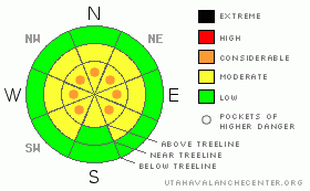
Danger Rose Tutorial
|
In mid and upper elevation terrain at and above treeline a Level 2 (MODERATE) avalanche danger exists today. Human triggered avalanches are possible, especially on steep wind drifted slopes. In the wind zone along the highest ridges, pockets of Level 3 (CONSIDERABLE) danger exist and human triggered avalanches are likely.
While becoming more pockety and harder to trigger, deep, dangerous avalanches breaking to the ground are still likely, especially in steep, rocky, upper elevation terrain facing the north half of the compass on slopes with a thin, weak underlying snowpack. In terrain with these characteristics, a Level 3 (CONSIDERABLE) avalanche danger exists. |
|
|
CURRENT CONDITIONS |

|
Bruce and I want to wish everyone a Merry Christmas!
A weak system bumping to the north of the region is ushering in some clouds and wind. East-southeast winds blew in the 20’s and 30’s yesterday, turning more southeasterly overnight and increasing into the low 40’s. Temperatures are in the low to mid 20’s. Upper elevation terrain got a little worked by yesterday’s wind, but got settled powder will still be found on north facing wind sheltered slopes. |
|
|
RECENT ACTIVITY |

|
Pretty quiet yesterday and no reports of recent avalanche activity, but nearly everywhere you look, there’s evidence of lots of big avalanches throughout the range that ran during the storm.
Click here for recent avalanche and snowpack observations.
Click here for the Cherry Hill accident summary. |
|
|
THREAT #1 |

|
| WHERE |
PROBABILITY |
SIZE |
TREND |

|
|
|
|
| |
|
|
Over the next
24 hours.
|
|
|
East and southeast winds increased earlier than expected yesterday, rapidly building sensitive drifts on slopes with both a north and westerly component to their aspect. There’s plenty of snow available for transport and the drifts are dense and hard. Unfortunately, this makes conditions a little trickier as these are the types of avalanches that break above you. Today’s slabs are easy to detect and avoid. They’ll appear rounded or pillow-like, chalky, and sound hollow like a drum. Yesterday I found these conditions not only on the leeward side of ridges, but a little lower down-slope and around chutes, gullies and sub-ridges. Slabs triggered today will pack a punch and can easily knock you off your sled, skis or board and take you for an unexpected ride. |
|
|
THREAT #2 |

|
| WHERE |
PROBABILITY |
SIZE |
TREND |

|
|
|
|
| |
|
|
Over the next
24 hours.
|
|
|
Utah’s a pretty remarkable place- incredible mountains, unbelievable terrain, and a self healing snowpack. In general the snowpack is beginning to turn a corner towards overall strength, and stability tests indicate this trend, especially in terrain where the pack is thick. But you know already, we don’t trigger deep slides in strong snow. We trigger deep slides where the snow is thin and weak. In the western Uinta’s, steep, rocky terrain with a thin underlying snowpack has always been our Achilles’ heel and this is the type of terrain where the wheels could come off the bus today. While the chances of triggering a deep slide are diminishing the consequences remain quite severe and you wouldn’t go to Vegas with those odds. If you want to ride steep terrain safely, look for slopes that already avalanched big during the storm. No it’s not going to be over-the-hood virgin powder, and those slopes might be a little bumpy underneath, but the upside is you’ll come home to your family safe and sound. |
|
|
MOUNTAIN WEATHER |

|
A weak storm moves into the region late today with a few inches of snow expected overnight. High temperatures reach into the upper 20’s and low 30’s with overnight lows crashing into the low teens. Southeast winds will be a nuisance, blowing 15-30 mph with gusts in the 50’s along the high ridges, before turning more westerly and backing off later tonight. Partly cloudy skies and cool temperatures for Monday before a cold pacific storm system impacts the region late Tuesday through at least Thursday. |
|
|
GENERAL ANNOUNCEMENTS |
The information in this advisory expires 24 hours after the date and time posted, but will be updated by 7:00 AM Wednesday December 29th.
If you’re getting out and about and trigger an avalanche or see anything interesting please drop me an email at craig@utahavalanchecenter.org or call 801-231-2170
Also, now is a great time to schedule one of our free avalanche awareness presentations for your group or club. Email or call me and we’ll get you booked before things get too crazy.
Many thanks to all the great folks at Tri-City Performance and Polaris for their extremely generous donation to the Utah Avalanche Center. You guys… and gals rock! Click here to see Craig’s new ride.
The western Uinta advisory program is going full tilt and forecasts will be issued by 7:00 AM on Wednesday, Saturday, Sunday and all holidays. |
|
|
This information does not apply to developed ski areas or highways where avalanche control is normally done. This advisory is from the U.S.D.A. Forest Service, which is solely responsible for its content. This advisory describes general avalanche conditions and local variations always occur. |
|
This advisory provided by the USDA Forest Service, in partnership with:
The Friends of the Utah Avalanche Center, Utah Division of State Parks and Recreation, Utah Division of Emergency Management, Salt Lake County, Salt Lake Unified Fire Authority and the friends of the La Sal Avalanche Center. See our Sponsors Page for a complete list. |
