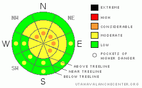
BOTTOM LINE
Danger by aspect and elevation on slopes approaching 35° or steeper.
(click HERE for tomorrow's danger rating)
|
Danger Rose Tutorial
|
In mid and upper elevation terrain at and above treeline a Level 2 (MODERATE) avalanche danger exists today. Human triggered avalanches are possible, especially on steep wind drifted slopes at upper elevations in the wind zone.
While becoming more pockety and harder to trigger, deep, dangerous avalanches breaking to the ground are still likely, especially in steep, rocky, upper elevation terrain facing the north half of the compass on slopes with a thin, weak underlying snowpack. In terrain with these characteristics, a Level 3 (CONSIDERABLE) avalanche danger exists.
With warming temperatures, the danger of wet avalanches will rise to Level 2 (MODERATE) on steep, sun baked, low elevation slopes |
|
|
CURRENT CONDITIONS |

|
Bruce and I want to wish everyone a Merry Christmas!
Other than a few high clouds, skies remain clear as a strong inversion takes hold. Winds are light, less than 15 mph and temperatures are in the teens at 8,000’ and mid 20’s at 10,000’. The new storm snow is settling, the coverage is amazing, and the riding and turning conditions are about as good as it gets. |
|
|
RECENT ACTIVITY |

|
Nearly everywhere you look, there’s evidence of lots of big avalanches throughout the range that ran during the storm.
Click here for recent avalanche and snowpack observations.
Click here for the Cherry Hill accident summary. |
|
|
THREAT #1 |

|
| WHERE |
PROBABILITY |
SIZE |
TREND |
|
|
|
|
| |
|
|
Over the next
24 hours.
|
|
|
All the new storm snow is settling and gaining strength rapidly and that’s the good news. The bad news is there are several weak layers within and underneath all this new snow that are still adjusting to the big storm. It’ll take a slope with some steepness to get things rolling, but once initiated, slabs can break wider and deeper than you might expect. Be alert to signs of instability like cracking, whoomphing sounds and recent avalanche activity. |
|
|
THREAT #2 |

|
| WHERE |
PROBABILITY |
SIZE |
TREND |

|
|
|
|
| |
|
|
Over the next
24 hours.
|
|
|
Utah’s a pretty remarkable place- incredible mountains, unbelievable terrain, and a self healing snowpack. In general the snowpack is beginning to turn a corner towards overall strength, and stability tests indicate this trend, especially in terrain where the pack is thick. But you know already, we don’t trigger deep slides in strong snow. We trigger deep slides where the snow is thin and weak. In the western Uinta’s, steep, rocky terrain with a thin underlying snowpack has always been our Achilles’ heel and this is the type of terrain where the wheels could come off the bus today. While the chances of triggering a deep slide are diminishing the consequences remain quite severe and you wouldn’t go to Vegas with those odds. If you want to ride steep terrain safely, look for slopes that already avalanched big during the storm. No it’s not going to be over-the-hood virgin powder, and those slopes might be a little bumpy underneath, but the upside is you’ll come home to your family safe and sound. |
|
|
THREAT #3 |

|
| WHERE |
PROBABILITY |
SIZE |
TREND |

|
|
|
|
| |
|
|
Over the next
24 hours.
|
|
|
While high, thin clouds may keep wet avalanche activity at bay, as the day heats up, avoid low elevation terrain traps like gullies and road cuts where debris can pile up deeply. |
|
|
MOUNTAIN WEATHER |

|
A mild southerly flow increases today, ahead of a weak storm system which will cross the area Sunday. Mid and high level clouds drift into the region and temperatures climb into the upper 30’s and low 40’s. Overnight lows dip into the mid 20’s. Winds remain light and southeasterly, blowing 10-20 mph along the high ridges. A westerly flow develops for the first half of the week, before a much stronger and colder system impacts the region Wednesday into Thursday. |
|
|
GENERAL ANNOUNCEMENTS |
The information in this advisory expires 24 hours after the date and time posted, but will be updated by 7:00 AM Sunday December 26th.
If you’re getting out and about and trigger an avalanche or see anything interesting please drop me an email at craig@utahavalanchecenter.org or call 801-231-2170
Also, now is a great time to schedule one of our free avalanche awareness presentations for your group or club. Email or call me and we’ll get you booked before things get too crazy.
Many thanks to all the great folks at Tri-City Performance and Polaris for their extremely generous donation to the Utah Avalanche Center. You guys… and gals rock! Click here to see Craig’s new ride.
The western Uinta advisory program is going full tilt and forecasts will be issued by 7:00 AM on Wednesday, Saturday, Sunday and all holidays. |
|
|
This information does not apply to developed ski areas or highways where avalanche control is normally done. This advisory is from the U.S.D.A. Forest Service, which is solely responsible for its content. This advisory describes general avalanche conditions and local variations always occur. |
|
This advisory provided by the USDA Forest Service, in partnership with:
The Friends of the Utah Avalanche Center, Utah Division of State Parks and Recreation, Utah Division of Emergency Management, Salt Lake County, Salt Lake Unified Fire Authority and the friends of the La Sal Avalanche Center. See our Sponsors Page for a complete list. |
