BOTTOM LINE
Danger by aspect and elevation on slopes approaching 35° or steeper.
(click HERE for tomorrow's danger rating)
|
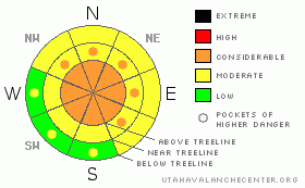
Danger Rose Tutorial
|
In mid and upper elevation terrain at and above treeline a Level 3 (CONSIDERABLE) avalanche danger exists today. Human triggered avalanches are likely, especially on wind drifted slopes steeper than about 35 degrees.
In addition to wind drifts, deep, dangerous avalanches breaking to the ground are likely, especially in steep, rocky, upper elevation terrain facing the north half of the compass on slopes with a thin, weak underlying snowpack. In terrain with these characteristics, a Level 3 (CONSIDERABLE) avalanche danger exists. Avalanches triggered today in this type of terrain will be deep, dangerous and possibly unsurvivable.
Out of the wind in mid elevation terrain, new storm snow is the issue and a Level 2 (MODERATE) avalanche danger exists and human triggered avalanches are possible on steep slopes.
With warming temperatures, the danger of wet avalanches will rise to Level 2 (MODERATE) on steep, sun baked, low elevation slopes |
|
|
CURRENT CONDITIONS |

|
Above the Salt Lake fog, skies are partly cloudy, northwest winds light and blowing less than 10 mph, and temperatures are right around 10 degrees. Total snow depths have settled to nearly 70” and most remote snow sites are between 175- 200% of normal. |
|
|
RECENT ACTIVITY |

|
Yesterday, Ted found a small, natural pocket on a steep, rocky slope on Gold Hill.
Click here for recent snowpack observations.
Click here for the Cherry Hill accident summary. |
|
|
THREAT #1 |

|
| WHERE |
PROBABILITY |
SIZE |
TREND |
|
|
|
|
| |
|
|
Over the next
24 hours.
|
|
|
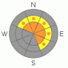
What an amazing storm cycle for the eastern front, and man… the western Uinta’s are white! All the new snow is settling and gaining strength rapidly and that’s the good news. The bad news is there are several weak layers underneath all this new snow. It’ll take a slope with some steepness to get things rolling, but once initiated, slabs can break wider and deeper than you might expect. Be alert to signs of instability like cracking, whoomphing sounds and recent avalanche activity. |
|
|
THREAT #2 |

|
| WHERE |
PROBABILITY |
SIZE |
TREND |
|
|
|
|
| |
|
|
Over the next
24 hours.
|
|
|
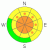
Sunshine, lots of fresh powder, and a holiday…. sounds like a great marketing campaign, but it’s actually the perfect recipe for an avalanche accident. Remember- the snowpack has been slammed with an incredible amount of water weight and new snow and it needs some time to adjust. It’s gonna be tricky out there the next couple of days and warming temperatures may become a factor, adding more stress to the snowpack in the short term. While many slopes have avalanched, things got filled in so quickly it’s hard to say what’s remained intact and what has slid, further complicating the stability pattern. Unless you’re really on your game and you’ve been tracking the avalanche cycle your best bet today is to avoid riding steep slopes. Avalanches triggered on steep mid and upper elevation, north facing slopes, still have the potential to break into weak layers of snow near the ground. This would produce a large, dangerous, and possibly unsurvivable slide. Even if you’re playing on low angle terrain, think about steep slopes above you and ones you’re connected to. |
|
|
THREAT #3 |

|
| WHERE |
PROBABILITY |
SIZE |
TREND |

|
|
|
|
| |
|
|
Over the next
24 hours.
|
|
|
With warming temperatures, even the low elevation terrain will get in on the act and wet avalanches will become a player. As the day heats up, avoid terrain traps like gullies and road cuts where debris can pile up deeply. |
|
|
MOUNTAIN WEATHER |

|
With a strong ridge of high pressure in place, we’ll see sunny skies today and tomorrow with temperatures warming into the low to mid 30’s. Overnight lows dip into the mid 20’s. Winds remain light, less than 15 mph. A weak system crosses the region Sunday into Monday. The next winter storm could potentially impact the region late next week. This system looks like a colder storm with a northwest flow. |
|
|
GENERAL ANNOUNCEMENTS |
The information in this advisory expires 24 hours after the date and time posted, but will be updated by 7:00 AM Saturday December 25th with a holiday advisory.
If you’re getting out and about and trigger an avalanche or see anything interesting please drop me an email at craig@utahavalanchecenter.org or call 801-231-2170
Also, now is a great time to schedule one of our free avalanche awareness presentations for your group or club. Email or call me and we’ll get you booked before things get too crazy.
Many thanks to all the great folks at Tri-City Performance and Polaris for their extremely generous donation to the Utah Avalanche Center. You guys… and gals rock! Click here to see Craig’s new ride.
The western Uinta advisory program is going full tilt and forecasts will be issued by 7:00 AM on Wednesday, Saturday, Sunday and all holidays. |
|
|
This information does not apply to developed ski areas or highways where avalanche control is normally done. This advisory is from the U.S.D.A. Forest Service, which is solely responsible for its content. This advisory describes general avalanche conditions and local variations always occur. |
|
This advisory provided by the USDA Forest Service, in partnership with:
The Friends of the Utah Avalanche Center, Utah Division of State Parks and Recreation, Utah Division of Emergency Management, Salt Lake County, Salt Lake Unified Fire Authority and the friends of the La Sal Avalanche Center. See our Sponsors Page for a complete list. |
