AVALANCHE WARNING »
Dangerous avalanche conditions are occuring or are imminent.
Backcountry travel in avalanche terrain is not recommended.
|
 |
Notice: An Avalanche Warning remains in effect for the western Uinta Mountains. A (LEVEL 4) HIGH danger exists and backcountry travelers should avoid all avalanche terrain and stay out from underneath steep slopes above. |
|
|
BOTTOM LINE
Danger by aspect and elevation on slopes approaching 35° or steeper.
(click HERE for tomorrow's danger rating)
|
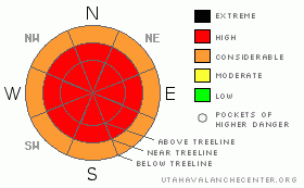
Danger Rose Tutorial
|
In mid and upper elevation terrain at and above treeline a Level 4 (HIGH) avalanche danger exists today. Human triggered avalanches are very likely, especially on wind drifted slopes approaching about 35 degrees.
In addition to sensitive wind drifts, deep, dangerous avalanches breaking to the ground are likely, especially in steep, rocky, upper elevation terrain facing the north half of the compass on slopes with a thin, weak underlying snowpack. In particular, terrain to the east and south of the central core of the western Uintas would be likely suspects. Avalanches triggered today in this type of terrain will be deep, dangerous and possibly unsurvivable.
Even the low elevation terrain is getting in on the act where a Level 3 (CONSIDERABLE) danger exists. Human triggered avalanches are likely on slopes steeper than 35 degrees. |
|
|
CURRENT CONDITIONS |

|
A southwest flow over the region is the gift that keeps giving. In the past 24 hours an additional 6” of ultra-light, blower powder fell on the North Slope. But the bigger story is the southern half of the range where nearly a foot of snow stacked up since yesterday morning and total snow depths have doubled in the past few days. Winds are blowing less than 15 mph and temperatures are in the upper teens and mid 20’s. In most places it’s a wallowfest, but riding and turning conditions are over-the-head and over-the-hood and bordering on epic. |
|
|
RECENT ACTIVITY |

|
While visibility has been marginal at best, natural avalanches in steep mid and upper elevation terrain have been spotted. In addition, recent human triggered avalanches breaking about 2’ deep are reported as unusually wide. Click here for recent avalanche observations.
In addition, folks reported very audible, booming collapses and shooting cracks on upper elevation slopes with a shallow snowpack.
Click here for recent snowpack observations.
Click here for the Cherry Hill accident summary. |
|
|
THREAT #1 |

|
| WHERE |
PROBABILITY |
SIZE |
TREND |

|
|
|
|
| |
|
|
Over the next
24 hours.
|
|
|
A remarkable amount of dense, heavy, wet, storm snow has fallen on the light, fluffy powder from last week and as you know, this upside down cake isn’t a good deal. Anytime there’s strong snow resting on weak snow there’s a problem. The storm snow has consolidated the past few days and is more slab-like, breaking wider than you might expect and packing a good punch. In wind loaded terrain today’s slabs will be several feet deep, they’re breaking wide, and stacking up deep piles of debris. Because of the incredible amount of new snow we’re dealing with, their characteristics are bordering on unmanageable. |
|
|
THREAT #2 |

|
| WHERE |
PROBABILITY |
SIZE |
TREND |
|
|
|
|
| |
|
|
Over the next
24 hours.
|
|
|
Deep, dangerous avalanches that are always unmanageable can still be triggered on steep, mid and upper elevation slopes facing the north half of the compass. The problem might be slightly more elevated in our perimeter terrain to the east and south, where snow depths have remained shallow all winter, but are now rapidly catching up. In any case, these aren’t the types of avalanches we can outrun. While many slopes have avalanched naturally, many more are waiting for a trigger like us to come along. Avalanches triggered today have the potential to break into deeper buried weak layers, producing a dangerous and possibly unsurvivable slide. Even if you’re playing on low angle terrain, think about steep slopes above and connected to you. Avalanches can still be triggered from a distance and on relatively flat terrain. |
|
|
MOUNTAIN WEATHER |

|
Light snow showers this morning will increase in intensity later today as a warm front lifts from the south through the region. High temperatures warm into the upper 20’s and southwest winds increase throughout the day, gusting into the 30’s by about dinner time. It all ramps back up for Wednesday with the heaviest period of snow and water expected during the day. Snow showers linger into Thursday with ridging slated for Friday and Saturday. High temperatures look quite warm for Christmas with plenty of sunshine. |
|
|
GENERAL ANNOUNCEMENTS |
The information in this advisory expires 24 hours after the date and time posted, but will be updated by 7:00 AM Wednesday December 22nd.
If you’re getting out and about and trigger an avalanche or see anything interesting please drop me an email at craig@utahavalanchecenter.org or call 801-231-2170
Also, now is a great time to schedule one of our free avalanche awareness presentations for your group or club. Email or call me and we’ll get you booked before things get too crazy.
Many thanks to all the great folks at Tri-City Performance and Polaris for their extremely generous donation to the Utah Avalanche Center. You guys… and gals rock! Click here to see Craig’s new ride.
The western Uinta advisory program is going full tilt and forecasts will be issued by 7:00 AM on Wednesday, Saturday, Sunday and all holidays. |
|
|
This information does not apply to developed ski areas or highways where avalanche control is normally done. This advisory is from the U.S.D.A. Forest Service, which is solely responsible for its content. This advisory describes general avalanche conditions and local variations always occur. |
|
This advisory provided by the USDA Forest Service, in partnership with:
The Friends of the Utah Avalanche Center, Utah Division of State Parks and Recreation, Utah Division of Emergency Management, Salt Lake County, Salt Lake Unified Fire Authority and the friends of the La Sal Avalanche Center. See our Sponsors Page for a complete list. |
