AVALANCHE WARNING »
Dangerous avalanche conditions are occuring or are imminent.
Backcountry travel in avalanche terrain is not recommended.
|
 |
Notice: There is an Avalanche Warning for all the mountains of Utah where a A (LEVEL 4) HIGH danger exists with an (LEVEL 5) EXTREME danger for the Provo area mountains.
Backcountry travelers should avoid all avalanche terrain and stay out from underneath steeper slopes above. |
|
|
BOTTOM LINE
Danger by aspect and elevation on slopes approaching 35° or steeper.
(click HERE for tomorrow's danger rating)
|

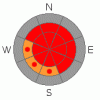
Danger Rose Tutorial
|
In mid and upper elevation terrain at and above treeline a Level 4 (HIGH) avalanche danger exists today. Natural avalanches are likely, human triggered avalanches are certain, especially on wind drifted slopes approaching about 35 degrees.
In addition to sensitive wind drifts, deep, dangerous avalanches breaking to the ground are likely, especially in steep, rocky, upper elevation terrain facing the north half of the compass on slopes with a thin, weak underlying snowpack. In particular, terrain to the east and south of the central core of the western Uintas would be likely suspects. Avalanches triggered today in this type of terrain will be deep, dangerous and possibly unsurvivable.
Even the low elevation terrain is getting in on the act where a Level 3 (CONSIDERABLE) danger exists. Human triggered avalanches are likely on slopes steeper than 35 degrees. |
|
|
CURRENT CONDITIONS |

|
Wow… what a storm! Most mountain locations have received close to 3’ of dense, heavy snow since Friday. Snow totals are pretty staggering, but water weight really tells the story. Nearly all remote weather stations report close to 3” of water and Trial Lake crushes all of its neighbors with a storm total of 4.7” of H2O. West and southwest winds cranked throughout the night, averaging in the 30’s and 40’s with gusts in the 60’s and 70’s along the high ridges. They’ve mellowed out slightly, turning more westerly, but are still blowing 25-40 mph along the high peaks. Currently, temperatures are in the mid 20’s. |
|
|
RECENT ACTIVITY |

|
Lots of avalanche activity yesterday, both natural and human triggered. Nearly all the slides are running on last week’s lighter density snow. Averaging about 1½' - 2’ deep, they’re breaking wide, running further than you might expect, and stacking up deep piles of debris. Click here for recent avalanche observations.
Click here for recent snowpack observations.
Click here for the Cherry Hill accident summary. |
|
|
THREAT #1 |

|
| WHERE |
PROBABILITY |
SIZE |
TREND |

|
|
|
|
| |
|
|
Over the next
24 hours.
|
|
|
Yesterday’s manageable avalanches were becoming unmanageable by late in the day and strong winds overnight created a whole new round of deep, sensitive drifts. Slabs have grown thicker and can be triggered from a distance, even on relatively flat terrain. Even small slides are packing a punch and stacking up impressive piles of debris. |
|
|
THREAT #2 |

|
| WHERE |
PROBABILITY |
SIZE |
TREND |
|
|
|
|
| |
|
|
Over the next
24 hours.
|
|
|
The huge amounts of snow and water are desperately taxing the strength of our snowpack. Slopes that haven’t already slid are just waiting for a trigger like us to come along and tip the balance. While the snow may feel dense and strong under our track, there are plenty of weak layers near the ground for avalanches to fail on. Today you’ll need to stay off of and out from under any steep wind drifted slope. Avalanches triggered today in steep mid and upper elevation terrain with a weak underlying snow have the potential to break to the ground, creating a large, dangerous and possibly unsurvivable avalanche. Even if you’re playing on relatively low angle terrain, think about steep slopes above and connected to where you’re at. |
|
|
MOUNTAIN WEATHER |

|
Snow should begin to taper off the next couple of hours as the strong cold front now positioned over Provo Canyon continues its southward progression. Winds will shift to the northwest and continue to decrease to about 10-20 mph with a few gusts in the 30’s along the high ridges. High temperatures hover in the mid 20’s. The pattern remains active, reloading with another round of warming southwesterly flow later tonight through Wednesday night. |
|
|
GENERAL ANNOUNCEMENTS |
The information in this advisory expires 24 hours after the date and time posted, but will be updated by 7:00 AM Tuesday December 21st.
If you’re getting out and about and trigger an avalanche or see anything interesting please drop me an email at craig@utahavalanchecenter.org or call 801-231-2170
Also, now is a great time to schedule one of our free avalanche awareness presentations for your group or club. Email or call me and we’ll get you booked before things get too crazy.
Many thanks to all the great folks at Tri-City Performance and Polaris for their extremely generous donation to the Utah Avalanche Center. You guys… and gals rock! Click here to see Craig’s new ride.
The western Uinta advisory program is going full tilt and forecasts will be issued by 7:00 AM on Wednesday, Saturday, Sunday and all holidays. |
|
|
This information does not apply to developed ski areas or highways where avalanche control is normally done. This advisory is from the U.S.D.A. Forest Service, which is solely responsible for its content. This advisory describes general avalanche conditions and local variations always occur. |
|
This advisory provided by the USDA Forest Service, in partnership with:
The Friends of the Utah Avalanche Center, Utah Division of State Parks and Recreation, Utah Division of Emergency Management, Salt Lake County, Salt Lake Unified Fire Authority and the friends of the La Sal Avalanche Center. See our Sponsors Page for a complete list. |
