AVALANCHE WARNING »
Dangerous avalanche conditions are occuring or are imminent.
Backcountry travel in avalanche terrain is not recommended.
|
 |
Notice: An AVALANCHE WARNING has been issued for all the mountains of northern, central and southern Utah. A HIGH danger exists in the Ogden and Provo area mountains. With continued snow and strong winds the avalanche danger will increase to HIGH overnight in the remaining areas of northern, central and southern Utah. Backcountry travelers should avoid travel on or below steep slopes.
This warning does not include ski areas or highways where avalanche control work is normally done. |
|
|
BOTTOM LINE
Danger by aspect and elevation on slopes approaching 35° or steeper.
(click HERE for tomorrow's danger rating)
|
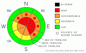
Danger Rose Tutorial
|
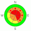
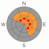
In upper elevation terrain at and above treeline a Level 3 (CONSIDERABLE) danger exists this morning. Both new and older wind slabs will be sensitive to the additional weight of a rider. Human triggered avalanches are likely, especially on slopes steeper than about 35 degrees. With additional snow and wind the avalanche danger will certainly rise to Level 4 (HIGH) by days end.
In addition to sensitive wind drifts, deep, dangerous avalanches breaking to the ground are likely, especially in steep, rocky, upper elevation terrain facing the north half of the compass on slopes with a thin, weak underlying snowpack. In particular, terrain to the east and south of the central core of the western Uintas would be likely suspects. Avalanches triggered today in this type of terrain will be deep, dangerous and possibly unsurvivable.
If you’re looking for Level 1 (LOW) danger, stick to low angle slopes at low elevations with no steep terrain above or adjacent to where you’re riding. |
|
|
CURRENT CONDITIONS |

|
A nice shot of heavy, dense snow developed yesterday, delivering just over a foot to the southern half of the range, from Daniels to Trial Lake. The North Slope got short changed on this southwest flow, but just about 6” fell in the past 24 hours. Southwest and westerly winds have been busy at work blowing 15-30 mph along the ridges, gusting into the 40’s and low 50’s along the high peaks. The best riding and turning conditions are found in mid elevation wind sheltered terrain. |
|
|
RECENT ACTIVITY |

|
Numerous reports yesterday of very sensitive shallow soft slabs, 6”-10” deep, in mid and upper elevation, wind loaded terrain. These very manageable slabs were breaking on weak near surface facets and buried surface hoar.
Click here for recent snowpack observations.
Click here for the Cherry Hill accident summary. |
|
|
THREAT #1 |

|
| WHERE |
PROBABILITY |
SIZE |
TREND |
|
|
|
|
| |
|
|
Over the next
24 hours.
|
|
|
The avalanche danger will be on the rise today as the new snow starts to stack up and winds continue blowing. As the storm continues to evolve avalanche conditions are going to become tricky. Yesterday’s manageable soft slabs will break deeper and wider and will pack a punch today. Wind drifts have grown thicker overnight and could easily be several feet deep along the leeward side of mid and upper elevation ridges. You’re gonna have to be on your game the next couple of days and pay close attention to rapidly changing avalanche and weather conditions. Look and listen for clues to unstable snow- cracking, whoomphing sounds and the hugest freebie of all… recent avalanche activity. |
|
|
THREAT #2 |

|
| WHERE |
PROBABILITY |
SIZE |
TREND |
|
|
|
|
| |
|
|
Over the next
24 hours.
|
|
|
This is a good storm for the western Uinta’s and with just over an inch of water in the past 24 hours, we’re starting to add critical water weight to the snowpack. This is the time when most avalanche professionals start to fine tune their avalanche radar. I’m not too concerned about terrain where our snowpack is deep and strong. It’s the outliers that have me sketched. For the moment, the snowpack seems pretty squared away in the central core of the range and on the North Slope where total snow depths are close to five feet deep. However, as you know the Uinta’s are a big place and there’s plenty of slopes, especially to the east and south, that have a shallow snowpack, which is reeling from this additional load of wet, heavy snow and sustained winds. While the snow may feel dense and strong under our track, there are plenty of weak layers near the ground for avalanches to fail on. These are the kinds of conditions that lead to most avalanche accidents in the western Uinta’s. Today you’ll need to stay off of and out from under any steep wind drifted slope. Avalanches triggered today in steep mid and upper elevation terrain with a weak underlying snow have the potential to break to the ground, creating a large, dangerous and possibly unsurvivable avalanche. Even if you’re playing on relatively low angle terrain, think about steep slopes above and connected to where you’re at. |
|
|
MOUNTAIN WEATHER |

|
The moist southwest flow will continue to bring snow and wind to the region today and we can expect an additional 3”-6” during the day. Southwest winds will blow 15-30 mph with gusts increasing to 50 mph later this afternoon. High temperatures reach into the low to mid 30’s. Overnight lows crash into the mid teens as a strong cold front races through the region during the second half of the night. An additional 4”-8” of snow is expected with snow rapidly tapering off in the morning. Another system is slated to reach the region late Monday, lingering into Thursday and we can expect yet another big shot of wind, water, and snow. |
|
|
GENERAL ANNOUNCEMENTS |
The information in this advisory expires 24 hours after the date and time posted, but will be updated by 7:00 AM Monday December 20th.
If you’re getting out and about and trigger an avalanche or see anything interesting please drop me an email at craig@utahavalanchecenter.org or call 801-231-2170
Also, now is a great time to schedule one of our free avalanche awareness presentations for your group or club. Email or call me and we’ll get you booked before things get too crazy.
Many thanks to all the great folks at Tri-City Performance and Polaris for their extremely generous donation to the Utah Avalanche Center. You guys… and gals rock! Click here to see Craig’s new ride.
The western Uinta advisory program is going full tilt and forecasts will be issued by 7:00 AM on Wednesday, Saturday, Sunday and all holidays. |
|
|
This information does not apply to developed ski areas or highways where avalanche control is normally done. This advisory is from the U.S.D.A. Forest Service, which is solely responsible for its content. This advisory describes general avalanche conditions and local variations always occur. |
|
This advisory provided by the USDA Forest Service, in partnership with:
The Friends of the Utah Avalanche Center, Utah Division of State Parks and Recreation, Utah Division of Emergency Management, Salt Lake County, Salt Lake Unified Fire Authority and the friends of the La Sal Avalanche Center. See our Sponsors Page for a complete list. |
