AVALANCHE WATCH »
The risk of an avalanche is expected to increase significantly
but the timing and location are still uncertain. Stay tuned for updates.
|
 |
Notice: An AVALANCHE WATCH has been issued for the mountains of northern and central Utah, to include the Bear River Range, the Western Uintas and the Wasatch Plateau. Expected wet heavy snowfall and wind over the weekend and into next week will create dangerous avalanche conditions in the backcountry. The danger will be on the rise and backcountry travelers should exercise caution with the changing conditions. |
|
|
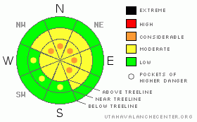
BOTTOM LINE
Danger by aspect and elevation on slopes approaching 35° or steeper.
(click HERE for tomorrow's danger rating)
|
Danger Rose Tutorial
|
In upper elevation terrain at and above treeline a Level 2 (MODERATE) danger exists. Both new storm snow and fresh wind slabs will be sensitive to the additional weight of a rider. Human triggered avalanches are possible, especially on slopes steeper than about 35 degrees. In addition- deep, dangerous avalanches breaking to the ground are still possible. Pockets of Level 3 (CONSIDERABLE) danger exist particularly in steep, rocky, upper elevation terrain facing the north half of the compass on slopes with a thin, weak snowpack.
Out of the wind in mid and low elevation terrain the avalanche danger is generally Level 1 (LOW). |
|
|
CURRENT CONDITIONS |

|
A very moist series of storms are just starting to bear down on the region and the first piece is right at our doorstep. Light snow is falling, temperatures are in the low to mid 20’s, and southwest winds are blowing 15-25 mph along the high ridges. Excellent riding and turning conditions will be found today in mid elevation, wind sheltered terrain. |
|
|
RECENT ACTIVITY |

|
Sluffing on steep slopes.
Click here for recent snowpack observations.
Click here for the Cherry Hill accident summary. |
|
|
THREAT #1 |

|
| WHERE |
PROBABILITY |
SIZE |
TREND |

|
|
|
|
| |
|
|
Over the next
24 hours.
|
|
|
The avalanche danger will be on the rise the next few days as the new snow starts to stack up. For today, though the most obvious issue is within the new storm snow. Easy to manage, today’s avalanches will break at or below your sled, board, or skis. New snow sluffs will easily gouge into last week’s light, fluffy powder, entraining a bit more snow than you might expect. Take care that a manageable slide doesn’t get out of hand and slam you into a group of trees or knock you over a cliff. While winds aren’t expected to get too outrageous, should they pick up for any length of time, shallow soft slabs will become sensitive to the weight of a rider. |
|
|
THREAT #2 |

|
| WHERE |
PROBABILITY |
SIZE |
TREND |

|
|
|
|
| |
|
|
Over the next
24 hours.
|
|
|
In general, the snowpack is looking quite good and it’s much different than what we’re used to dealing with on the eastern front. This year’s pack is a little deeper, a little warmer, and more predictable. In most mid and low elevation terrain, deeper weak layers near the ground have strengthened over time and in the short term, we’re looking pretty good. However, in high elevation terrain on shady slopes facing the north half of the compass, the snowpack is less homogenous. (Check out this snowpit profile) There are slopes that still have weak, shallow snow and you know by now that means trouble. While they’re getting harder to trigger, deep avalanches breaking to the ground are still possible, especially in steep, rocky terrain with a thin, weak snowpack. |
|
|
MOUNTAIN WEATHER |

|
An active weather pattern is in store for the next couple of days with the heaviest snow expected late Sunday afternoon into Monday. In the mean time, snow should fall throughout the day with 2”-4” expected today and an additional 2”-4” tonight. Southwest winds should remain manageable, in the 15-25 mph range, though we might see a gust or two in the 30’s along the high ridges. Temperatures reach into the low 30’s at 8,000’ and mid 20’s at 10,000’. Overnight lows dip into the low 20’s. Snowfall tapers off this evening, but ramps back up again late Sunday when a big piece of moisture moves onshore and this should be a good shot of snow for the western Uinta Mountains. |
|
|
GENERAL ANNOUNCEMENTS |
The information in this advisory expires 24 hours after the date and time posted, but will be updated by 7:00 AM Sunday December 19th.
If you’re getting out and about and trigger an avalanche or see anything interesting please drop me an email at craig@utahavalanchecenter.org or call 801-231-2170
Also, now is a great time to schedule one of our free avalanche awareness presentations for your group or club. Email or call me and we’ll get you booked before things get too crazy.
Many thanks to all the great folks at Tri-City Performance and Polaris for their extremely generous donation to the Utah Avalanche Center. You guys… and gals rock! Click here to see Craig’s new ride.
The western Uinta advisory program is going full tilt and forecasts will be issued by 7:00 AM on Wednesday, Saturday, Sunday and all holidays. |
|
|
This information does not apply to developed ski areas or highways where avalanche control is normally done. This advisory is from the U.S.D.A. Forest Service, which is solely responsible for its content. This advisory describes general avalanche conditions and local variations always occur. |
|
This advisory provided by the USDA Forest Service, in partnership with:
The Friends of the Utah Avalanche Center, Utah Division of State Parks and Recreation, Utah Division of Emergency Management, Salt Lake County, Salt Lake Unified Fire Authority and the friends of the La Sal Avalanche Center. See our Sponsors Page for a complete list. |
