BOTTOM LINE
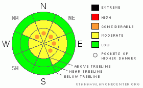
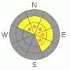
Danger by aspect and elevation on slopes approaching 35° or steeper.
(click HERE for tomorrow's danger rating)
|

Danger Rose Tutorial
|
In the wind zone at and above treeline a Level 2 (MODERATE) danger exists and fresh wind slabs will be sensitive to the additional weight of a rider. Human triggered avalanches are possible, especially on steep slopes with recent deposits of wind drifted snow. In addition- deep, dangerous avalanches breaking to the ground are still possible. Pockets of Level 3 (CONSIDERABLE) danger exist particularly in steep, rocky, upper elevation terrain facing the north half of the compass on slopes with a thin, weak snowpack.
Out of the wind in mid and low elevation terrain the avalanche danger is generally Level 1 (LOW). |
|
|
CURRENT CONDITIONS |

|
A cold front racing through the region deposited 4” of snow in most upper elevation terrain overnight. Gusty south and southwest winds blew in the 30’s and 40’s all day yesterday, dying down into the 20’s and 30’s early this morning. Temperatures also dropped around 4:00 AM and are currently in the low to mid 20’s. Riding and turning conditions remain quite good, especially in mid elevation wind sheltered terrain. |
|
|
RECENT ACTIVITY |

|
No new avalanches to report.
Click here for recent snowpack observations.
Click here for the Cherry Hill accident summary. |
|
|
THREAT #1 |

|
| WHERE |
PROBABILITY |
SIZE |
TREND |

|
|
|
|
| |
|
|
Over the next
24 hours.
|
|
|
Sensitive wind drifts formed all day yesterday and overnight and they’ll be found along and just off the leeward side of upper elevation ridges. Easy to detect by their rounded appearance, today’s wind drifts are manageable, breaking at or below your sled, board or skis. As always, take care one of these doesn’t catch you off guard and knock you into a tree or over a cliff band. |
|
|
THREAT #2 |

|
| WHERE |
PROBABILITY |
SIZE |
TREND |

|
|
|
|
| |
|
|
Over the next
24 hours.
|
|
|
In general, the snowpack is looking quite good and it’s much different than what we’re used to dealing with on the eastern front. This year’s pack is a little deeper, a little warmer, and more predictable. Unfortunately, those are the same types of characteristics that allow us to let our guard down and start getting deeper into the avalanche dragons den. In most mid and low elevation terrain, deeper weak layers near the ground have strengthened over time and in the short term, we’re good to go. However, in high elevation terrain on shady slopes facing the north half of the compass, the snowpack is less homogenous. (Check out this snowpit profile) There are slopes that still have weak, shallow snow and you know by now that means trouble. While they’re getting harder to trigger, deep avalanches breaking to the ground are still possible, especially in steep, rocky terrain with a thin, weak snowpack. |
|
|
MOUNTAIN WEATHER |

|
A cold, northwest flow will continue producing snow through the early morning hours and we should see storm totals around 8” or so, before skies clear later this morning. Winds shift to the northwest and blow 15-25 mph before dying down this afternoon. High temperatures don’t vary much from where we’re at this morning and overnight lows dip into the single digits. Some high clouds drift through the region for Thursday and Friday and then it gets interesting. A warm front crosses the area late Friday night or Saturday morning with a very moist but mild southwest flow following the front. Heavy snow is expected Saturday with snow levels rising to 8000 feet in the afternoon, remaining there into Sunday. The mild and moist southwest flow returns Monday and persists into mid week. |
|
|
GENERAL ANNOUNCEMENTS |
The information in this advisory expires 24 hours after the date and time posted, but will be updated by 7:00 AM Saturday December 18th.
If you’re getting out and about and trigger an avalanche or see anything interesting please drop me an email at craig@utahavalanchecenter.org or call 801-231-2170
Also, now is a great time to schedule one of our free avalanche awareness presentations for your group or club. Email or call me and we’ll get you booked before things get too crazy.
Many thanks to all the great folks at Tri-City Performance and Polaris for their extremely generous donation to the Utah Avalanche Center. You guys… and gals rock! Click here to see Craig’s new ride.
The western Uinta advisory program is going full tilt and forecasts will be issued by 7:00 AM on Wednesday, Saturday, Sunday and all holidays. |
|
|
This information does not apply to developed ski areas or highways where avalanche control is normally done. This advisory is from the U.S.D.A. Forest Service, which is solely responsible for its content. This advisory describes general avalanche conditions and local variations always occur. |
|
This advisory provided by the USDA Forest Service, in partnership with:
The Friends of the Utah Avalanche Center, Utah Division of State Parks and Recreation, Utah Division of Emergency Management, Salt Lake County, Salt Lake Unified Fire Authority and the friends of the La Sal Avalanche Center. See our Sponsors Page for a complete list. |

