SPECIAL ANNOUNCEMENT |
 |
Both Windy Peak and Lofty Lake Peak wind sites are up and running. Click here for real time wind and snow data. |
|
|
BOTTOM LINE
Danger by aspect and elevation on slopes approaching 35° or steeper.
(click HERE for tomorrow's danger rating)
|
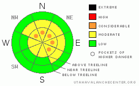
Danger Rose Tutorial
|
In the wind zone at and above treeline a Level 2 (MODERATE) danger exists. Both new and old wind slabs will be sensitive to the additional weight of a rider. Human triggered avalanches are possible, especially on steep slopes with recent deposits of wind drifted snow. In addition- deep, dangerous avalanches breaking to the ground are still possible. Pockets of Level 3 (CONSIDERABLE) danger exist particularly in steep, rocky, upper elevation terrain facing the north half of the compass on slopes with a thin, weak snowpack.
Out of the wind in mid and low elevation terrain the avalanche danger is generally Level 1 (LOW). |
|
|
CURRENT CONDITIONS |

|
A building ridge over the area will give us clearing skies and warming temperatures. Winds are blowing out of the west and northwest at 15-30 mph and current temperatures are in the upper 20’s and low 30’s. With great coverage and fresh snow the riding and turning conditions are mid-winteresque and about as good as it gets for this time of year. |
|
|
RECENT ACTIVITY |

|
Reports of shallow soft slabs about a foot deep were triggered yesterday in steep wind loaded terrain.
One remotely triggered slide was reported on Wednesday on a high elevation, north facing slope. Breaking 1’-4’ deep and 400’ wide, this avalanche failed on weak snow near the ground.
Click here for recent snowpack observations.
Click here for the Cherry Hill accident summary. |
|
|
THREAT #1 |

|
| WHERE |
PROBABILITY |
SIZE |
TREND |

|
|
|
|
| |
|
|
Over the next
24 hours.
|
|
|
Mostly manageable in size and breaking at or below your skis, board or sled, sensitive wind drifts will still be lurking along the leeward side of upper elevation ridges today. Friday’s strong winds deposited snow a little lower on the slope than we’re used to, so be cautious when approaching mid- slope breakovers and sub-ridges. |
|
|
THREAT #2 |

|
| WHERE |
PROBABILITY |
SIZE |
TREND |
|
|
|
|
| |
|
|
Over the next
24 hours.
|
|
|
When you envision a deep, stable snowpack you think- warm temperatures, a consistent storm track, a thick snowpack, and homogenous layering. Most of what I’ve been seeing in the western Uinta’s is beginning to point in this direction. But just like High School gym class, you can see there are plenty of slopes than haven’t quite matured to this state and remain thin, awkward and unsure of themselves. Sure the coverage is great and in general the snowpack is on the mend. Unfortunately though, there are still some thinner areas that are connected to the thicker, strong ones and that’s a dangerous combination. Remember- we trigger deep, dangerous slides from thin spots in the snowpack not where it’s thick and strong. Another fly in ointment is the warming temperatures and they’ll begin to put additional stress on the snowpack. Yes it remains tricky out there and human triggered avalanches can still break to the ground especially in steep, rocky terrain with a weak, underlying snowpack. This makes up a small portion of the terrain available for us to ride and there’s no reason to pull the dogs tail today. While the chances of triggering a big slide are diminishing the consequences remain severe. |
|
|
MOUNTAIN WEATHER |

|
A warm front moves east of the area by midday and this should produce clearing skies and warming temperatures. Highs are expected to reach into the mid to upper 30’s with overnight lows dipping into the upper 20’s. Northwest winds will continue to decrease through the morning. Strong high pressure builds over area this afternoon through Monday bringing very warm and dry conditions. Another cold front is expected Tuesday night. |
|
|
GENERAL ANNOUNCEMENTS |
The information in this advisory expires 24 hours after the date and time posted, but will be updated by 7:00 AM Wednesday December 15th.
If you’re getting out and about and trigger an avalanche or see anything interesting please drop me an email at craig@utahavalanchecenter.org or call 801-231-2170
Also, now is a great time to schedule one of our free avalanche awareness presentations for your group or club. Email or call me and we’ll get you booked before things get too crazy.
Many thanks to all the great folks at Tri-City Performance and Polaris for their extremely generous donation to the Utah Avalanche Center. You guys… and gals rock! Click here to see Craig’s new ride.
The western Uinta advisory program is going full tilt and forecasts will be issued by 7:00 AM on Wednesday, Saturday, Sunday and all holidays. |
|
|
This information does not apply to developed ski areas or highways where avalanche control is normally done. This advisory is from the U.S.D.A. Forest Service, which is solely responsible for its content. This advisory describes general avalanche conditions and local variations always occur. |
|
This advisory provided by the USDA Forest Service, in partnership with:
The Friends of the Utah Avalanche Center, Utah Division of State Parks and Recreation, Utah Division of Emergency Management, Salt Lake County, Salt Lake Unified Fire Authority and the friends of the La Sal Avalanche Center. See our Sponsors Page for a complete list. |
