SPECIAL ANNOUNCEMENT |
 |
Both Windy Peak and Lofty Lake Peak wind sites are up and running. Click here for real time wind and snow data. |
|
|
BOTTOM LINE
Danger by aspect and elevation on slopes approaching 35° or steeper.
(click HERE for tomorrow's danger rating)
|
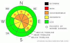
Danger Rose Tutorial
|
In the wind zone at and above treeline a Level 3 (CONSIDERABLE) danger exists. Both new and old wind slabs will be sensitive to the additional weight of a rider. Human triggered avalanches are likely, especially on steep north, northeast and east facing slopes. In addition- deep, dangerous avalanches breaking to the ground are still possible, particularly in steep, rocky terrain facing the north half of the compass on slopes with a thin, weak snowpack.
A Level 2 (MODERATE) danger exists on all steep, mid elevation, wind drifted slopes and human triggered avalanches are possible.
Out of the wind in mid and low elevation terrain the avalanche danger is generally Level 1 (LOW). |
|
|
CURRENT CONDITIONS |

|
A nice shot of snow moved through the region on Friday delivering an evenly disbursed 10” of medium density snow throughout the range. Looks like Trial Lake received more of the goods with just over 12” reported. Even the trailheads got in on the act where up to 8” of snow fell. The new snow is big news, but the winds are even bigger… they cranked out of the south and southwest all day yesterday, gusting into the 70’s along the high ridges. Things mellowed out slightly overnight, but they’re starting to ramp up and change direction. Generally out of the west, winds are averaging 25 mph with gusts in the low 40’s. Skies are mostly cloudy and temperatures are in the low to mid 20’s. There’s probably quite a bit of wind jacked snow out there, but in wind sheltered terrain at lower elevations riding and turning conditions remain quite good. |
|
|
RECENT ACTIVITY |

|
One remotely triggered slide was reported on Wednesday on a high elevation, north facing slope. Breaking 1’-4’ deep and 400’ wide, this avalanche failed on weak snow near the ground.
Click here for recent snowpack observations.
Click here for the Cherry Hill accident summary. |
|
|
THREAT #1 |

|
| WHERE |
PROBABILITY |
SIZE |
TREND |
|
|
|
|
| |
|
|
Over the next
24 hours.
|
|
|
Wind slabs will be today’s primary and most obvious avalanche concern. Because of the strong winds, today’s slabs will be well off the ridgelines, forming mid slope and around terrain features like chutes and gullies. Mostly found on slopes facing the north half of the compass, they may be stubborn, but once initiated could break deeper and wider than you’d expect. Remember to look for and avoid any fat looking, rounded pillow of snow, especially if it sounds hollow like a drum. |
|
|
THREAT #2 |

|
| WHERE |
PROBABILITY |
SIZE |
TREND |
|
|
|
|
| |
|
|
Over the next
24 hours.
|
|
|
Not much new in this department. While it’s getting harder to trigger deep, dangerous avalanches the possibility still exists and the consequences are severe. Where the pack is thick, say four to five feet deep or so, we’re good to go. But as you know, we don’t trigger deep avalanches that break to the ground where the snow is deep and strong, we trigger these types of slides where the pack is thin and weak. Remember- shallow snow is dangerous snow, especially when it’s connected to a thick slab above or adjacent to the terrain we’re riding in. Once we collapse the snowpack we’re off to the races. So we’re back to our usual problem child… steep, rocky, upper elevation terrain remains suspect and if you trigger an avalanche in this type of terrain it’s going to be deep, wide and possibly unsurvivable. |
|
|
MOUNTAIN WEATHER |

|
A break in the active weather pattern is on tap this morning, though we could still see a stray snow shower or two. A strong warm front moves across the region late this afternoon and tonight, producing yet another round of burly ridgetop winds. Westerly winds will average 15-30 mph with gusts in the low 60’s along the high ridges. Overnight, the winds will switch to the west-northwest and will be nukin’ into the 70’s and 80’s. Temperatures remain mild with highs reaching into the upper 20’s. Overnight lows dip into the mid 20’s. High pressures builds into the region Sunday and Monday, giving us mostly sunny skies and very warm temperatures with highs climbing into the low 40’s. More storminess is on the way for later next week. |
|
|
GENERAL ANNOUNCEMENTS |
The information in this advisory expires 24 hours after the date and time posted, but will be updated by 7:00 AM Sunday December 12th.
If you’re getting out and about and trigger an avalanche or see anything interesting please drop me an email at craig@utahavalanchecenter.org or call 801-231-2170
Also, now is a great time to schedule one of our free avalanche awareness presentations for your group or club. Email or call me and we’ll get you booked before things get too crazy.
Many thanks to all the great folks at Tri-City Performance and Polaris for their extremely generous donation to the Utah Avalanche Center. You guys… and gals rock! Click here to see Craig’s new ride.
The western Uinta advisory program is going full tilt and forecasts will be issued by 7:00 AM on Wednesday, Saturday, Sunday and all holidays. |
|
|
This information does not apply to developed ski areas or highways where avalanche control is normally done. This advisory is from the U.S.D.A. Forest Service, which is solely responsible for its content. This advisory describes general avalanche conditions and local variations always occur. |
|
This advisory provided by the USDA Forest Service, in partnership with:
The Friends of the Utah Avalanche Center, Utah Division of State Parks and Recreation, Utah Division of Emergency Management, Salt Lake County, Salt Lake Unified Fire Authority and the friends of the La Sal Avalanche Center. See our Sponsors Page for a complete list. |
