SPECIAL ANNOUNCEMENT |
 |
We'll be giving a free, snowmobile specific avalanche awareness presentation at 6:00 this Wednesday Dec. 8th at Smith and Edwards. Click here for more details.
Also, both Windy Peak and Lofty Lake Peak wind sites are up and running. Click here for real time wind and snow data. |
|
|
BOTTOM LINE
Danger by aspect and elevation on slopes approaching 35° or steeper.
(click HERE for tomorrow's danger rating)
|
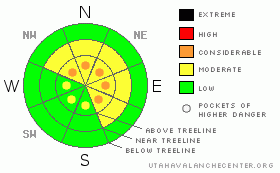
Danger Rose Tutorial
|
A Level 2 (MODERATE) danger exists on all steep, mid and upper elevation, wind drifted slopes and human triggered avalanches are possible. Be aware that within this elevation band, pockets of Level 3 (CONSIDERABLE) danger exist, especially in steep, rocky terrain facing the north half of the compass on slopes with a thin, weak snowpack. Avalanches triggered in this type of terrain continue to have the potential to break to the ground, creating a deep and dangerous slide.
In low elevation terrain the avalanche danger is generally Level 1 (LOW). |
|
|
CURRENT CONDITIONS |

|
Skies remained clear overnight, but a band of high clouds is working into the region. Temperatures remained rather mild and are in the low to mid 20’s. West and southwest winds increased just after midnight and are currently blowing 15-20 mph along the high ridges. Monday night’s storm favored the North Slope, depositing 8” of dense, springy snow and the riding and turning conditions are about as good as it gets for this time of year. |
|
|
RECENT ACTIVITY |

|
We spotted several natural wind slabs which broke in upper elevation wind loaded terrain, on slopes facing east, northeast and southeast. 10”-14” deep and up to 200’ wide, these slabs were running a little further and faster than you might expect.
Click here for recent snowpack observations. Big thanks to Johnny, Kurt and Micheal for the great observations this week!
Click here for the Cherry Hill accident summary. |
|
|
THREAT #1 |

|
| WHERE |
PROBABILITY |
SIZE |
TREND |
|
|
|
|
| |
|
|
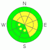
Over the next
24 hours.
|
|
|
Some lingering wind slabs still exist along the leeward side of upper elevation ridges and by later in the day a whole new batch of drifts will form. While not quite as touchy as yesterday, a rider could trigger one of these drifts and possibly go for an unexpected ride. Easy to detect and easy to slope cut, once you’re out of the wind zone the drifting becomes a moot point. |
|
|
THREAT #2 |

|
| WHERE |
PROBABILITY |
SIZE |
TREND |
|
|
|
|
| |
|
|
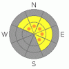
Over the next
24 hours.
|
|
|
In the short term, the deeper instabilities within the snowpack that we’ve been concerned with appear to be healing and that’s the good news. The bad news is- while it’s getting harder to trigger deep, dangerous avalanches the possibility still exists and the consequences are severe. Where the pack is thick, say four to five feet deep or so, we’re good to go. But as you know, we don’t trigger deep avalanches that break to the ground where the snow is deep and strong, we trigger these types of slides where the pack is thin and weak. I know it’s tough to wrap your brain around… heck it’s taken me a couple decades, but shallow snow is dangerous snow, especially when it’s connected to a thick slab above or adjacent to the terrain we’re riding in. Once we collapse the snowpack we’re off to the races. So we’re back to our usual problem child… steep, rocky, upper elevation terrain remains suspect and if you trigger an avalanche in this type of terrain it’s going to be deep, wide and possibly unsurvivable. |
|
|
MOUNTAIN WEATHER |

|
Clouds will continue streaming into the region as high pressure shifts to the east allowing a moist westerly flow to develop. West and southwest winds gradually increase throughout the day, blowing into the 40’s along the high ridges by day’s end. Temperatures remain mild with highs in the mid 30’s at 8,000’ and upper 20’s to low 30’s at 10,000’. Overnight lows dip into the low 20’s. A slight chance of snow develops overnight and into Thursday, with a better shot slated for Friday. Storm totals look like 3”-6” by late Friday with another similar shot of snow moving through the region on Saturday. High pressure builds for the latter half of the weekend through early next week. |
|
|
GENERAL ANNOUNCEMENTS |
The information in this advisory expires 24 hours after the date and time posted, but will be updated by 7:00 AM Saturday December 11th.
If you’re getting out and about and trigger an avalanche or see anything interesting please drop me an email at craig@utahavalanchecenter.org or call 801-231-2170
Also, now is a great time to schedule one of our free avalanche awareness presentations for your group or club. Email or call me and we’ll get you booked before things get too crazy.
Many thanks to all the great folks at Tri-City Performance and Polaris for their extremely generous donation to the Utah Avalanche Center. You guys… and gals rock! Click here to see Craig’s new ride.
The western Uinta advisory program is going full tilt and forecasts will be issued by 7:00 AM on Wednesday, Saturday, Sunday and all holidays. |
|
|
This information does not apply to developed ski areas or highways where avalanche control is normally done. This advisory is from the U.S.D.A. Forest Service, which is solely responsible for its content. This advisory describes general avalanche conditions and local variations always occur. |
|
This advisory provided by the USDA Forest Service, in partnership with:
The Friends of the Utah Avalanche Center, Utah Division of State Parks and Recreation, Utah Division of Emergency Management, Salt Lake County, Salt Lake Unified Fire Authority and the friends of the La Sal Avalanche Center. See our Sponsors Page for a complete list. |
