SPECIAL ANNOUNCEMENT |
 |
We'll be giving a free, snowmobile specific avalanche awareness presentation at 6:00 this Wednesday Dec. 8th at Smith and Edwards. Click here for more details. |
|
|
BOTTOM LINE
Danger by aspect and elevation on slopes approaching 35° or steeper.
(click HERE for tomorrow's danger rating)
|
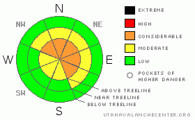
Danger Rose Tutorial
|
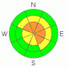
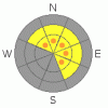
In steep, upper elevation terrain at and above treeline the avalanche danger remains at a Level 3 (CONSIDERABLE). While becoming more pockety, human triggered avalanches are likely on wind drifted slopes steeper than about 35 degrees, especially those facing the north half of the compass. Avalanches triggered today have the potential to be deep and dangerous.
A Level 2 (MODERATE) danger exists on all steep mid elevation, wind drifted slopes and human triggered avalanches are possible.
In low elevation terrain the avalanche danger is generally Level 1 (LOW). |
|
|
CURRENT CONDITIONS |

|
Skies are mostly cloudy, temperatures are in the upper 20’s and low 30’s and it’s feeling more like spring than early winter. Southerly winds cranked along the high peaks for most of Saturday, averaging in the mid 20’s with gusts in the 40’s, though around 1:00 this morning they backed off and are currently blowing 10-15 mph along the high ridges. Riding and turning conditions remain quite good especially in mid elevation wind sheltered terrain where the snow is dense and spongy. |
|
|
RECENT ACTIVITY |

|
A few natural wind slabs were spotted on Thursday in Weber Canyon on upper elevation easterly facing slopes. The biggest slide occurred on a steep, east facing slope at 10,700’ in elevation. It was 2’ deep, 250’ wide, running 450’ vertical.
In addition to natural activity, one snowcat triggered slide was reported on a heavily wind loaded, upper elevation slope. This slide averaged 2’ deep, but broke to the ground in some places and was 100’ wide.
Click here for recent snowpack observations.
Click here for the Cherry Hill accident summary. Several large, natural avalanches in the same region were spotted yesterday. |
|
|
THREAT #1 |

|
| WHERE |
PROBABILITY |
SIZE |
TREND |
|
|
|
|
| |
|
|
Over the next
24 hours.
|
|
|
Winds have been blowing for the past couple of days forming slabs along the leeward side of upper elevation ridges. Both old and fresh drifts are found in the wind zone, at and above treeline, on slopes facing the north half of the compass. Most of these slabs are stubborn and hard to trigger, but once initiated they’ll pack a bigger punch than you might expect. That being said… any wind loaded slope should be approached with caution today. |
|
|
THREAT #2 |

|
| WHERE |
PROBABILITY |
SIZE |
TREND |
|
|
|
|
| |
|
|
Over the next
24 hours.
|
|
|
Our bigger problem child, weak snow near the ground, is still a player though recent warm temperatures are helping to keep this nemesis at bay. While it’s getting harder to trigger deep, dangerous avalanches remember- all it takes is finding a weakness somewhere in a shallow portion of the snowpack, collapsing the pack, and we’re off to the races. Any steep, upper elevation, windloaded slope, facing the north half of the compass remains suspect and these aren’t the types of avalanches we outrun and shake off the snow once the dust settles. There are miles and miles of safe terrain to ride in today. However, if your travels take you into steep, upper elevation terrain, especially north facing slopes that have a very cohesive slab which rests on weak snow near the ground, the potential still exists for avalanches to break near the ground, creating a large and dangerous slide. |
|
|
MOUNTAIN WEATHER |

|
Not much change in the weather department. Today, look for mostly cloudy skies and mild temperatures with highs reaching into the mid to upper 30’s. Overnight lows dip into the mid 20’s. Southwest winds increase late tonight and gust into the low 40’s along the high ridges as a weak storm brushes by the region. We can expect light snow for Monday with accumulations in the 2”-4” range, a break on Tuesday and after that it looks like most of the storm systems bump to the north of the state…. there’s no big storms in sight. |
|
|
GENERAL ANNOUNCEMENTS |
The information in this advisory expires 24 hours after the date and time posted, but will be updated by 7:00 AM Wednesday December 8th.
If you’re getting out and about and trigger an avalanche or see anything interesting please drop me an email at craig@utahavalanchecenter.org or call 801-231-2170
Also, now is a great time to schedule one of our free avalanche awareness presentations for your group or club. Email or call me and we’ll get you booked before things get too crazy.
Many thanks to all the great folks at Tri-City Performance and Polaris for their extremely generous donation to the Utah Avalanche Center. You guys… and gals rock! Click here to see Craig’s new ride.
The western Uinta advisory program is going full tilt and forecasts will be issued by 7:00 AM on Wednesday, Saturday, Sunday and all holidays. |
|
|
This information does not apply to developed ski areas or highways where avalanche control is normally done. This advisory is from the U.S.D.A. Forest Service, which is solely responsible for its content. This advisory describes general avalanche conditions and local variations always occur. |
|
This advisory provided by the USDA Forest Service, in partnership with:
The Friends of the Utah Avalanche Center, Utah Division of State Parks and Recreation, Utah Division of Emergency Management, Salt Lake County, Salt Lake Unified Fire Authority and the friends of the La Sal Avalanche Center. See our Sponsors Page for a complete list. |
