SPECIAL ANNOUNCEMENT |
 |
I'll be giving a free, snowmobile specific avalanche awareness presentation at Tri-City Performance in Springville this Saturday Dec. 4th at 2:00. |
|
|
BOTTOM LINE
Danger by aspect and elevation on slopes approaching 35° or steeper.
(click HERE for tomorrow's danger rating)
|

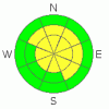
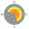
Danger Rose Tutorial
|
In steep, upper elevation terrain at and above treeline the avalanche danger is at Level 3 (CONSIDERABLE) meaning dangerous avalanche conditions exist. While becoming more pockety, human triggered avalanches are likely on wind drifted slopes steeper than about 35 degrees, especially those facing the north half of the compass. Avalanches triggered today have the potential to be deep and dangerous.
A Level 2 (MODERATE) danger exists on all steep mid elevation, wind drifted slopes and human triggered avalanches are possible.
In low elevation terrain that had no snow prior to the big storm cycle, the avalanche danger is generally Level 1 (LOW). |
|
|
CURRENT CONDITIONS |

|
Skies are cloudy, light snow is falling and temperatures have warmed into the mid 20’s overnight. West and southwest winds are blowing 10-20 mph with gusts in the low 30’s along the high ridges. Upper elevation total snow depths are right around 40”. The riding and turning conditions remain quite good, especially in wind sheltered terrain. |
|
|
RECENT ACTIVITY |

|
Click here for the Cherry Hill accident summary. Several large, natural avalanches in the same region were spotted yesterday.
Click here for profiles and observations near Whitney Basin and and here for Upper Weber Canyon. |
|
|
THREAT #1 |

|
| WHERE |
PROBABILITY |
SIZE |
TREND |
|
|
|
|
| |
|
|
Over the next
24 hours.
|
|
|
A few shallow wind drifts will be found on the leeward side of upper elevation ridges today. They’re manageable is size and predictably breaking at or below your sled, board or skis. |
|
|
THREAT #2 |

|
| WHERE |
PROBABILITY |
SIZE |
TREND |
|
|
|
|
| |
|
|
Over the next
24 hours.
|
|
|
Our bigger and more unpredictable nemesis, deeper avalanches triggered near the ground, is still out there. While deep slides are getting harder to trigger the consequences remain every bit as severe. Yesterday, we found lots of safe slopes we could ride, but backed away from steep, upper elevation, northerly terrain, especially slopes that had very hard feeling snow under our sled and skis. Problem is- once you dig down and look at the snowpack structure underneath this very dense, wind driven snow, you’ll find all the ingredients for a dangerous avalanche- a strong slab (last week’s big storm), a weak layer (facets underneath early November crust) and a bed surface (the ground). Now all we need to do is come along and tip the balance or knock the legs out from under the slab and we’ll be staring down the barrel of a very dangerous slide. The snowpack is slowly healing and in time we’ll be riding the big terrain safely. Right now however, is not the time to test the waters and take a chance to see if something is going to avalanche… the consequences are just too devastating. |
|
|
MOUNTAIN WEATHER |

|
A weak storm grazing the northern third of the state will give us cloudy skies and light snow showers with minimal accumulations. Winds blow out of the west and southwest 15-30 mph with a few gusts in the low 40’s along the high ridges. Temperatures remain balmy with highs in the mid 20’s. Overnight lows dip into the teens. High pressure briefly builds later tonight into Thursday, giving us partly cloudy skies, before another weak system grazes the area for Friday and Saturday. |
|
|
GENERAL ANNOUNCEMENTS |
The information in this advisory expires 24 hours after the date and time posted, but will be updated by 7:00 AM Saturday December 4th.
If you’re getting out and about and trigger an avalanche or see anything interesting please drop me an email at craig@utahavalanchecenter.org or call 801-231-2170
Also, now is a great time to schedule one of our free avalanche awareness presentations for your group or club. Email or call me and we’ll get you booked before things get too crazy.
Many thanks to all the great folks at Tri-City Performance and Polaris for their extremely generous donation to the Utah Avalanche Center. You guys… and gals rock! Click here to see Craig’s new ride.
The western Uinta advisory program is going full tilt and forecasts will be issued by 7:00 AM on Wednesday, Saturday, Sunday and all holidays. |
|
|
This information does not apply to developed ski areas or highways where avalanche control is normally done. This advisory is from the U.S.D.A. Forest Service, which is solely responsible for its content. This advisory describes general avalanche conditions and local variations always occur. |
|
This advisory provided by the USDA Forest Service, in partnership with:
The Friends of the Utah Avalanche Center, Utah Division of State Parks and Recreation, Utah Division of Emergency Management, Salt Lake County, Salt Lake Unified Fire Authority and the friends of the La Sal Avalanche Center. See our Sponsors Page for a complete list. |
