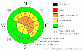
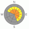
BOTTOM LINE
Danger by aspect and elevation on slopes approaching 35° or steeper.
(click HERE for tomorrow's danger rating)
|
Danger Rose Tutorial
|
In steep, upper elevation terrain at and above treeline the avalanche danger is at Level 3 (CONSIDERABLE) meaning dangerous avalanche conditions exist. Human triggered avalanches are likely on wind drifted slopes steeper than about 35 degrees, especially those facing the north half of the compass. Avalanches triggered today have the potential to be deep and dangerous.
A Level 2 (MODERATE) danger exists on all steep mid elevation, wind drifted slopes and human triggered avalanches are possible.
In low elevation terrain that had no snow prior to the big storm cycle, the avalanche danger is generally Level 1 (LOW). |
|
|
CURRENT CONDITIONS |

|
Skies are clear this morning, winds out of the west-northwest at 5-15 mph with gusts near 30 mph along the high ridges, and temperatures have rebounded nicely. With a bit of an inversion in place, current temperatures are in the mid to upper teens at 10,000’ and just about 10 degrees at the trailheads. All of this week’s new snow is providing excellent coverage and as the snow settles travel is getting easier. |
|
|
RECENT ACTIVITY |

|
No new avalanches to report. Click here for recent observations. |
|
|
THREAT #1 |

|
| WHERE |
PROBABILITY |
SIZE |
TREND |

|
|
|
|
| |
|
|
Over the next
24 hours.
|
|
|
Localized wind slabs remained sensitive to the weight of a rider yesterday along the high ridges and I think that’ll be the case again today. Breaking at or just below your sled, skis or board these are manageable avalanche conditions. Today’s wind slabs will be on the leeward side of upper elevation ridges and are easy to detect… they just look like rounded pillows of snow. As is always the case- you’ll want to look for and avoid any slope with recent deposits of wind drifted snow. |
|
|
THREAT #2 |

|
| WHERE |
PROBABILITY |
SIZE |
TREND |
|
|
|
|
| |
|
|
Over the next
24 hours.
|
|
|
Unmanageably large avalanches can still be triggered especially in steep, rocky, upper elevation terrain, facing the north half of the compass on slopes that had a pre-exisitng snowpack prior to last week’s big storm. The avalanche conditions remain tricky because you’ll be able to ride some steep slopes without a worry in the world. However, the snowpack structure remains suspect and I don’t trust it with my life. A strong slab now rests above a mid-pack weakness or two and under our sled, skis or board the snow we’re riding on will feel solid and good to go… and that’s the problem. Remember- we don’t trigger deep dangerous avalanches where the snow is thick and strong, we trigger them by finding a weak spot in the snowpack, like a shallow area around rock outcrops or bushes. To make matters more complicated, today’s rapidly warming temperatures will also put additional stress on a cold snowpack and may make some of our deeper, buried weak layers more sensitive to the weight of a rider. In any case, I’d exercise some patience, wait for the snowpack to heal, and get after the big terrain when the time is right. |
|
|
MOUNTAIN WEATHER |

|
Mostly sunny skies and warming temperatures are on tap for today. Highs reach into the upper 20’s at 8,000’ and mid 20’s at 10,000’. Overnight lows should be right around 20 degrees. Winds shift to the southwest late this afternoon as another good looking storm begins to approach the region. Increasing winds and clouds for Saturday with mild temperatures expected. Snow develops late tomorrow and seems a good bet for Sunday with accumulations close to a foot by Monday morning. High pressure returns for Tuesday. |
|
|
GENERAL ANNOUNCEMENTS |
The information in this advisory expires 24 hours after the date and time posted, but will be updated by 7:00 AM Saturday November 27th.
If you’re getting out and about and trigger an avalanche or see anything interesting please drop me an email at craig@utahavalanchecenter.org or call 801-231-2170
Also, now is a great time to schedule one of our free avalanche awareness presentations for your group or club. Email or call me and we’ll get you booked before things get too crazy.
Many thanks to all the great folks at Tri-City Performance and Polaris for their extremely generous donation to the Utah Avalanche Center. You guys… and gals rock! Click here to see Craig’s new ride.
The western Uinta advisory program is going full tilt and forecasts will be issued by 7:00 AM on Wednesday, Saturday, Sunday and all holidays. |
|
|
This information does not apply to developed ski areas or highways where avalanche control is normally done. This advisory is from the U.S.D.A. Forest Service, which is solely responsible for its content. This advisory describes general avalanche conditions and local variations always occur. |
|
This advisory provided by the USDA Forest Service, in partnership with:
The Friends of the Utah Avalanche Center, Utah Division of State Parks and Recreation, Utah Division of Emergency Management, Salt Lake County, Salt Lake Unified Fire Authority and the friends of the La Sal Avalanche Center. See our Sponsors Page for a complete list. |
