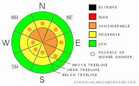
BOTTOM LINE
Danger by aspect and elevation on slopes approaching 35° or steeper.
(click HERE for tomorrow's danger rating)
|
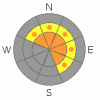
Danger Rose Tutorial
|
In steep terrain at mid and upper elevations at and above treeline the avalanche danger is at Level 3 (CONSIDERABLE) meaning dangerous avalanche conditions exist. Human triggered avalanches are likely on wind drifted slopes steeper than about 35 degrees, especially those facing the north half of the compass. Avalanches triggered today will be deep and dangerous.
A Level 2 (MODERATE) danger exists on all steep upper elevation, wind drifted, southerly facing slopes and human triggered avalanches are possible.
In low elevation terrain that had no snow prior to the big storm cycle, the avalanche danger is generally Level 1 (LOW). |
|
|
CURRENT CONDITIONS |

|
A trace of very light density snow fell yesterday. Skies cleared overnight and of course, temperatures crashed deep into negative territory. A slight inversion developed and it’s -10 or so at the trailheads, about the same at 10,000’. Not to be outdone, Lily Lake is -21 after bottoming out at -24 degrees. West-northwest winds blew 15-30 mph for most of yesterday, but backed off into the 5-15 mph range early this morning at most locations. Along the high peaks it’s still blowing 30-40 mph. Total snow depths around Trial Lake are close to 55”, 40” near Chalk Creek and about 25” in the Daniels area. Riding and turning conditions are epically deep and it’s an amazing start to the season! |
|
|
RECENT ACTIVITY |

|
Click here for recent observations. |
|
|
THREAT #1 |

|
| WHERE |
PROBABILITY |
SIZE |
TREND |

|
|
|
|
| |
|
|
Over the next
24 hours.
|
|
|
Once again, today’s primary and most manageable avalanche concern will be newly formed wind drifts. They’re most prevalent on the leeward side of ridges, though due to the winds strength, you’ll find these much lower downslope than you might expect, particularly at upper elevations. Be cautious when approaching mid slope breakovers and terrain features like chutes, gullies and sub-ridges. All of this is easy to avoid by staying off of steep wind drifted slopes. In addition, look for signs of unstable snow like shooting cracks, whoomphing sounds and of course the hugest clue, natural avalanche activity. |
|
|
THREAT #2 |

|
| WHERE |
PROBABILITY |
SIZE |
TREND |
|
|
|
|
| |
|
|
Over the next
24 hours.
|
|
|
Wicked cold temperatures like we’re experiencing not only affect us, they seem to lock up the snowpack- making it stiff, stubborn and unresponsive. Sounds good on paper, but when I look at all the snow and wind we’ve had in the past week, my gut tells me I still don’t trust the setup we’ve got going. With a strong slab resting above a mid-pack weakness or two all it takes is finding a weak spot in the snowpack- like around rocks or bushes- collapsing the pack and we’re staring down the barrel of a dangerous slide. Avalanches triggered today continue to have the potential to be deep and dangerous, breaking on weak layers of snow near the ground. Personally, I can’t remember if Dirty Harry fired five rounds or six and I’m not gonna pull on the dogs tail to find out if it bites. Sure you might be able to climb steep slopes without incident and think you’re good to go… that’s exactly how the avalanche dragon lures you deeper into its den. Your best bet the next couple days is to exercise patience, allow the snowpack to gain some strength and then when it’s good to go, get after it. |
|
|
MOUNTAIN WEATHER |

|
The very cold arctic airmass remains in place, though a bit of a reprieve is on its way. Temperatures will crack into positive territory with highs near 5 degrees and overnight lows near zero. West and northwest winds should remain in the 15-30 mph range along the high peaks, before mellowing out this afternoon. Partly cloudy skies are on tap with a warming trend developing for Friday and Saturday, before another good shot of snow moves into the region Saturday night into Sunday. |
|
|
GENERAL ANNOUNCEMENTS |
The information in this advisory expires 24 hours after the date and time posted, but will be updated by 7:00 AM Friday November 26th with a holiday forecast.
If you’re getting out and about and trigger an avalanche or see anything interesting please drop me an email at craig@utahavalanchecenter.org or call 801-231-2170
Also, now is a great time to schedule one of our free avalanche awareness presentations for your group or club. Email or call me and we’ll get you booked before things get too crazy.
Many thanks to all the great folks at Tri-City Performance and Polaris for their extremely generous donation to the Utah Avalanche Center. You guys… and gals rock! Click here to see Craig’s new ride.
The western Uinta advisory program is going full tilt and forecasts will be issued by 7:00 AM on Wednesday, Saturday, Sunday and all holidays. |
|
|
This information does not apply to developed ski areas or highways where avalanche control is normally done. This advisory is from the U.S.D.A. Forest Service, which is solely responsible for its content. This advisory describes general avalanche conditions and local variations always occur. |
|
This advisory provided by the USDA Forest Service, in partnership with:
The Friends of the Utah Avalanche Center, Utah Division of State Parks and Recreation, Utah Division of Emergency Management, Salt Lake County, Salt Lake Unified Fire Authority and the friends of the La Sal Avalanche Center. See our Sponsors Page for a complete list. |
