SPECIAL ANNOUNCEMENT |
 |
I’ve allowed the avalanche warning for the western Uinta Mountains to expire, however we’re not even close to being out of the woods just yet. Dangerous avalanche conditions still exist and people should stay off of steep, wind drifted slopes at mid and upper elevations, especially those facing the north half of the compass. The avalanche danger in this type of terrain is at Level 3 (CONSIDERABLE)-deep, dangerous, human triggered avalanches are likely. |
|
|
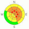
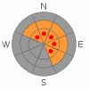
BOTTOM LINE
Danger by aspect and elevation on slopes approaching 35° or steeper.
(click HERE for tomorrow's danger rating)
|
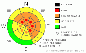
Danger Rose Tutorial
|
In steep terrain at mid and upper elevations at and above treeline the avalanche danger is at Level 3 (CONSIDERABLE) meaning dangerous avalanche conditions exist. Human triggered avalanches are likely on wind drifted slopes steeper than about 35 degrees, especially those facing the north half of the compass. Be aware that within this terrain, pockets of Level 4 (HIGH) danger exist. Avalanches triggered today will be deep and dangerous.
A Level 2 (MODERATE) danger exists on all steep upper elevation, wind drifted, southerly facing slopes and human triggered avalanches are possible.
In low elevation terrain that had no snow prior to this weekend’s storm the avalanche danger is generally Level 1 (LOW). |
|
|
CURRENT CONDITIONS |

|
The well advertised cold front roared through the region late yesterday, depositing an additional 6”-8” of very light density snow. The big winner in the overnight hours was Trial Lake which clocks in with 13” of cold smoke. Temperatures are a bit crisp. Currently it’s -16 degrees at Trial Lake and -6 at Chalk Creek and at most trailheads elevations. Winds are still an issue blowing west-northwest 15-25 mph with a few gusts in the low 40’s along the high ridges.
In the past seven days we’ve doubled and even tripled total snow depths in many locations and water totals are nearing 3.5” at the upper elevations. To put things in perspective- a week ago Trial Lake was at 24”… now averaging 54”, Chalk Creek was 14”…. now reading 43” and even our low elevation terrain got in on the act growing from 8” to 25”. It was a good storm for the eastern front! |
|
|
RECENT ACTIVITY |

|
We haven't been able to see a thing the past few days, but last weeks winds overloaded several steep, upper elevation, northerly facing slopes resulting in a few natural avalanches. The biggest slide occurred on Yamaha Hill and broke on weak snow near the ground. The avalanche was 1’-3’ deep, 200’ feet wide and ran about 350’ vertically. Click here for more details. |
|
|
THREAT #1 |

|
| WHERE |
PROBABILITY |
SIZE |
TREND |
|
|
|
|
| |
|
|
Over the next
24 hours.
|
|
|
The last gasp of the storm hit yesterday afternoon with very strong west and southwest winds gusting into 70’s along the high ridges. Wind switched to the northwest overnight and fresh drifts are found on nearly every upper elevation aspect. With plenty of new snow available to blow around, recently formed wind drifts will be today’s most obvious avalanche concern. They’ll be most prevalent on the leeward side of ridges, though due to the winds strength, you’ll find these much lower downslope than you might expect. Be cautious when approaching mid slope breakovers and terrain features like chutes, gullies and sub-ridges. All of this is easy to avoid by staying off of steep wind drifted slopes.In addition, look for signs of unstable snow like shooting cracks, whoomphing sounds and of course the hugest clue, natural avalanche activity. |
|
|
THREAT #2 |

|
| WHERE |
PROBABILITY |
SIZE |
TREND |
|
|
|
|
| |
|
|
Over the next
24 hours.
|
|
|
This has been a great storm for the Uinta’s and the coverage is at a mid winter premium. Come to think of it, there’s times when we don’t even have this much snow mid winter! I know we’re all chomping at the bit wanting to get after today, but we need to exercise a little patience as the snowpack tries to adjust to all the added weight. The avalanche danger remains deceivingly tricky and here’s why. In some lower and mid elevation terrain there was no snow prior to the big storm and those slopes will react much differently than ones that had a pre-existing snowpack. If you want to ride safely today, you’ll need to take a minute or two and determine the pattern before getting into steep terrain. The other wild card is the strong winds have created a solid feeling slab that will allow you to get well out onto the slope before it fails. This is exactly the type of set up when most avalanche accidents occur in the western Uinta mountains. Once triggered, today’s avalanches can break into weaker layers of snow near the ground creating a deep, dangerous slide. |
|
|
MOUNTAIN WEATHER |

|
It’ll be a cold day with occasional clouds and snow showers possible. Highs barely break zero degrees and overnight lows crash to near -15 degrees. West and northwest winds will remain a factor, blowing 10-20 mph with gusts in the 30’s and 40’s along the high ridges. Partly cloudy skies and a slight warming trend is on tap for Thursday and Friday with another trough developing for the weekend. |
|
|
GENERAL ANNOUNCEMENTS |
The information in this advisory expires 24 hours after the date and time posted, but will be updated by 7:00 AM Thursday November 25th with a holiday forecast.
If you’re getting out and about and trigger an avalanche or see anything interesting please drop me an email at craig@utahavalanchecenter.org or call 801-231-2170
Also, now is a great time to schedule one of our free avalanche awareness presentations for your group or club. Email or call me and we’ll get you booked before things get too crazy.
Many thanks to all the great folks at Tri-City Performance and Polaris for their extremely generous donation to the Utah Avalanche Center. You guys… and gals rock! Click here to see Craig’s new ride.
The western Uinta advisory program is going full tilt and forecasts will be issued by 7:00 AM on Wednesday, Saturday, Sunday and all holidays. |
|
|
This information does not apply to developed ski areas or highways where avalanche control is normally done. This advisory is from the U.S.D.A. Forest Service, which is solely responsible for its content. This advisory describes general avalanche conditions and local variations always occur. |
|
This advisory provided by the USDA Forest Service, in partnership with:
The Friends of the Utah Avalanche Center, Utah Division of State Parks and Recreation, Utah Division of Emergency Management, Salt Lake County, Salt Lake Unified Fire Authority and the friends of the La Sal Avalanche Center. See our Sponsors Page for a complete list. |
