AVALANCHE WARNING »
Dangerous avalanche conditions are occuring or are imminent.
Backcountry travel in avalanche terrain is not recommended.
|
 |
Notice: An avalanche warning remains in effect for the western Uinta Mountains. Strong winds coupled with heavy snow have produced dangerous avalanche conditions and travel in avalanche terrain is not recommended. People should stay off of steep, wind drifted slopes at mid and upper elevations, especially those facing the north half of the compass. The avalanche danger in this type of terrain is at Level 4 or High danger- meaning natural avalanches are likely and human triggered avalanches very likely. |
|
|
SPECIAL ANNOUNCEMENT |
 |
Many thanks to all the great folks at Tri-City Performance and Polaris for their extremely generous donation to the Utah Avalanche Center. You guys… and gals rock! Click here to see Craig’s new ride.
I’ll be giving a free avalanche awareness talk geared specifically for sledders Tuesday, Nov. 23rd at 6:00 at Smith and Edwards. Click here for more details
The western Uinta advisory program is going full tilt and forecasts will be issued by 7:00 AM on Wednesday, Saturday, Sunday and all holidays. |
|
|
BOTTOM LINE
Danger by aspect and elevation on slopes approaching 35° or steeper.
(click HERE for tomorrow's danger rating)
|
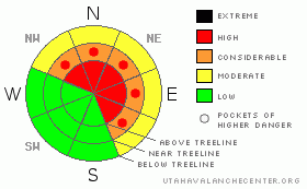
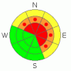
Danger Rose Tutorial
|
In steep upper elevation terrain at and above treeline the avalanche danger is at Level 4 (HIGH) meaning dangerous avalanche conditions exist. Natural avalanches are likely and human triggered avalanches are very likely on wind drifted slopes steeper than about 35 degrees, especially those facing the north half of the compass.
On all steep north, northeast and east facing slopes at mid elevation the avalanche danger is Level 3 (CONSIDERABLE) and dangerous human triggered avalanches are likely.
In low elevation terrain that had no snow prior to this weekend’s storm the avalanche danger is generally Level 1 (LOW). |
|
|
CURRENT CONDITIONS |

|
Man…. the Uintas are getting clobbered! In the past 24 hours Trial Lake picked up an additional 10” of snow with .80 water, Chalk Creek and Strawberry 7” with .80 water, and Daniels got hammered receiving 11” with 1.2” of water. In many areas around the range we’ve doubled and even tripled our total snow depths since the morning of the 20th. Currently, temperatures are near 10 degrees at 10,000’ and in the mid teens at the trailheads. West and southwest winds blew in the 30’s and 40’s overnight, have backed off slightly, but are expected to ramp up throughout the day. |
|
|
RECENT ACTIVITY |

|
We haven't been able to see a thing the past few days, but last weeks winds overloaded several steep, upper elevation, northerly facing slopes resulting in a few natural avalanches. The biggest slide occurred on Yamaha Hill and broke on weak snow near the ground. The avalanche was 1’-3’ deep, 200’ feet wide and ran about 350’ vertically. Click here for more details. |
|
|
THREAT #1 |

|
| WHERE |
PROBABILITY |
SIZE |
TREND |
|
|
|
|
| |
|
|
Over the next
24 hours.
|
|
|
Recent winds are creating tricky conditions and drifting is becoming more widespread. Avalanches may break deeper and wider than you might expect. Today you’ll want to avoid any steep slope with recent deposits of wind drifted snow. In addition, look for signs of unstable snow like shooting cracks, whoomphing sounds and of course the hugest clue, natural avalanche activity. |
|
|
THREAT #2 |

|
| WHERE |
PROBABILITY |
SIZE |
TREND |
|
|
|
|
| |
|
|
Over the next
24 hours.
|
|
|
What a phenomenal storm cycle for the eastern front! Unfortunately, the snowpack is reeling from all the raging wind and epic water weight. While I suspect many steep slopes have already avalanched naturally, problem is the visibility has been so meager it’s hard to say what slopes have slid and which ones are still intact. These are deceptively tricky avalanche conditions and to make matters more complicated some of our terrain had no snow prior to the big storm and they’ll react much differently than slopes that were already white and growing weak. If you’re getting out on the snow the next few days you’ll need to be on your avalanche game and you’re gonna have to dig around in the snow and figure out the pattern. If you’re not willing to spend some time investigating the lay of the land, then you might as well be in Vegas rolling the dice or pulling the lever. One thing’s for sure…. the house always wins!
This is exactly the type of set up when most avalanche accidents occur in the western Uinta mountains. Avalanches triggered today have the potential to break into weak layers of snow near the ground, creating a large and dangerous slide.
Remember- many early season avalanche accidents occur when we don’t think there’s enough snow to slide. If you’re getting into the mountains this weekend be aware of changing weather and avalanche conditions. Everyone in your group must have and know how to use an avalanche beacon, shovel and probe. |
|
|
MOUNTAIN WEATHER |

|
Strong west and southwest winds are expected throughout the day blowing 15-35 mph with gusts in the 50’s along the ridges. Additional snow accumulations should be in the 3”-6” range. Temperatures will remain cold with highs in the low to mid 20’s. Overnight lows dive into the teens. A better shot of snow develops late Tuesday, lingering into early Wednesday with a very cold airmass developing behind the front. Highs on Wednesday will have a hard time climbing out of negative territory. |
|
|
GENERAL ANNOUNCEMENTS |
The information in this advisory expires 24 hours after the date and time posted, but will be updated by 7:00 AM Wednesday November 24th.
If you’re getting out and about and trigger an avalanche or see anything interesting please drop me an email at craig@utahavalanchecenter.org or call 801-231-2170
Also, now is a great time to schedule one of our free avalanche awareness presentations for your group or club. Email or call me and we’ll get you booked before things get too crazy. |
|
|
This information does not apply to developed ski areas or highways where avalanche control is normally done. This advisory is from the U.S.D.A. Forest Service, which is solely responsible for its content. This advisory describes general avalanche conditions and local variations always occur. |
|
This advisory provided by the USDA Forest Service, in partnership with:
The Friends of the Utah Avalanche Center, Utah Division of State Parks and Recreation, Utah Division of Emergency Management, Salt Lake County, Salt Lake Unified Fire Authority and the friends of the La Sal Avalanche Center. See our Sponsors Page for a complete list. |
