AVALANCHE WARNING »
Dangerous avalanche conditions are occuring or are imminent.
Backcountry travel in avalanche terrain is not recommended.
|
 |
Notice: THIS AVALANCHE WARNING IS FOR THE WASATCH RANGE, WESTERN UINTAS AND BEAR RIVER RANGE. RECENT SNOW AND STRONG WINDS HAVE CREATED SENSITIVE AVALANCHE CONDITIONS ALONG HIGH ELEVATION RIDGES. THE DANGER IS MOST PRONOUNCED ABOVE ABOUT 9000 FEET IN ELEVATION. TO STAY OUT OF AVALANCHE DANGER, DO NOT TRAVEL IN TERRAIN APPROACHING 35 DEGREES IN STEEPNESS WITH RECENT DEPOSITS OF WIND DRIFTED SNOW. PEOPLE WITHOUT EXPERT LEVEL SNOW AND AVALANCHE ASSESSMENT SKILLS SHOULD AVOID BACKCOUNTRY TRAVEL TODAY. |
|
|
SPECIAL ANNOUNCEMENT |
 |
Many thanks to all the great folks at Tri-City Performance and Polaris for their extremely generous donation to the Utah Avalanche Center. You guys… and gals rock! Click here to see Craig’s new ride.
I’ll be giving a free avalanche awareness talk geared specifically for sledders Tuesday, Nov. 23rd at 6:00 at Smith and Edwards. Click here for more details
The western Uinta advisory program is going full tilt and forecasts will be issued by 7:00 AM on Wednesday, Saturday, Sunday and all holidays. |
|
|
BOTTOM LINE
Danger by aspect and elevation on slopes approaching 35° or steeper.
(click HERE for tomorrow's danger rating)
|
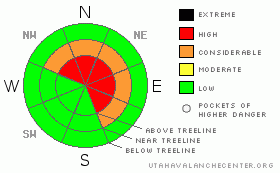
Danger Rose Tutorial
|
In steep upper elevation terrain at and above treeline the avalanche danger is at Level 3 (CONSIDERABLE) meaning dangerous avalanche conditions exist and human triggered avalanches are likely on wind drifted slopes steeper than about 35 degrees, especially those at mid and upper elevations facing the north half of the compass.
Within this type of terrain, pockets of Level 4 (HIGH) avalanche danger exist and natural avalanche activity may occur, especially during periods of strong wind and heavy snowfall.
In terrain that had no snow prior to this weekends storm the avalanche danger is generally Level 1 (LOW). |
|
|
CURRENT CONDITIONS |

|
Don't you just hate it when you go to publish your avalanche advisory and the power goes out. Sorry for the late post... not a good day to give up the Red Bull habit.
Wow.... what a storm! Snow totals are over a foot with 1.20" of water on the North Slope and around Mirror Lake. The south half of the range received about 8" of snow with nearly an inch of water. Smith-Moorehouse is clearly the winner with 16" and about 1.6" of water. Temperatures are in the low to mid 20's. Winds calmed over night, but have recently ramped up out of the west blowing 15-25 mph with gusts in the low 50's along the high ridges. Riding and turning conditions are improving, but just getting to the trailhead will be quite a task. |
|
|
RECENT ACTIVITY |

|
We couldn't see a thing yesterday, but strong midweek winds overloaded several steep, upper elevation, northerly facing slopes resulting in a few natural avalanches. The biggest slide occurred on Yamaha Hill and broke on weak snow near the ground. The avalanche was 1’-3’ deep, 200’ feet wide and ran about 350’ vertically. Click here for more details. |
|
|
THREAT #1 |

|
| WHERE |
PROBABILITY |
SIZE |
TREND |

|
|
|
|
| |
|
|
Over the next
24 hours.
|
|
|
Recent winds are creating tricky conditions and drifting is more widespread than in the past day or two. Avalanches may break deeper than you might expect. Today you’ll want to avoid any steep slope with recent deposits of wind drifted snow. In addition, look for signs of unstable snow like shooting cracks, whoomphing sounds and of course the hugest clue, natural avalanche activity. |
|
|
THREAT #2 |

|
| WHERE |
PROBABILITY |
SIZE |
TREND |

|
|
|
|
| |
|
|
Over the next
24 hours.
|
|
|
The cohesive slab formed by all the snow and wind is creating deceptively tricky avalanche conditions. Sure, the snow feels strong under our skis or sled and that’s just the problem. We’ve got to think not only about the surface snow we’re riding in, but also the deeper snow near the ground we’re riding on. As the storm continues to materialize weak layers deeper in the snowpack will become overloaded and begin to react to this additional weight. It’ll be dicey in steep, upper elevation terrain, facing the north half of the compass, especially on slopes that have a shallow, weak pre-existing snowpack. This is exactly the type of set up when most avalanche accidents occur in the western Uinta mountains. Avalanches triggered today have the potential to break into weak layers of snow near the ground, creating a large and dangerous slide.
Remember- many early season avalanche accidents occur when we don’t think there’s enough snow to slide. If you’re getting into the mountains this weekend be aware of changing weather and avalanche conditions. Everyone in your group must have and know how to use an avalanche beacon, shovel and probe. |
|
|
MOUNTAIN WEATHER |

|
A moist southwest flow increases today ahead of the next cold front. This front crosses the area mid afternoon with heavy snow. Accumulations by morning should be about a foot. Southwest winds also increase through the morning into the 40's with gusts in the 60's along the high ridges. They'll shift to the west and decrease during the afternoon. High temperatures will be in the low to mid 20's with overnight lows in the teens.Another shot of moisture keeps snow going through Monday. |
|
|
GENERAL ANNOUNCEMENTS |
The information in this advisory expires 24 hours after the date and time posted, but will be updated by 7:00 AM Wednesday November 24th.
If you’re getting out and about and trigger an avalanche or see anything interesting please drop me an email at craig@utahavalanchecenter.org or call 801-231-2170
Also, now is a great time to schedule one of our free avalanche awareness presentations for your group or club. Email or call me and we’ll get you booked before things get too crazy. |
|
|
This information does not apply to developed ski areas or highways where avalanche control is normally done. This advisory is from the U.S.D.A. Forest Service, which is solely responsible for its content. This advisory describes general avalanche conditions and local variations always occur. |
|
This advisory provided by the USDA Forest Service, in partnership with:
The Friends of the Utah Avalanche Center, Utah Division of State Parks and Recreation, Utah Division of Emergency Management, Salt Lake County, Salt Lake Unified Fire Authority and the friends of the La Sal Avalanche Center. See our Sponsors Page for a complete list. |
