AVALANCHE WATCH »
The risk of an avalanche is expected to increase significantly
but the timing and location are still uncertain. Stay tuned for updates.
|
 |
Notice: An Avalanche Watch has been issued for the Wasatch and western Uinta mountains of northern Utah. Periods of heavy snow and strong winds will create increasingly dangerous avalanche conditions Saturday afternoon through Tuesday, especially above 8,000'. People without avalanche training should avoid backcountry terrain. |
|
|
SPECIAL ANNOUNCEMENT |
 |
Many thanks to all the great folks at Tri-City Performance and Polaris for their extremely generous donation to the Utah Avalanche Center. You guys… and gals rock! Click here to see Craig’s new ride.
I’ll be giving a free avalanche awareness talk geared specifically for sledders Tuesday, Nov. 23rd at 6:00 at Smith and Edwards. Click here for more details
The western Uinta advisory program is going full tilt and forecasts will be issued by 7:00 AM on Wednesday, Saturday, Sunday and all holidays. |
|
|
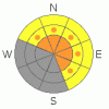
BOTTOM LINE
Danger by aspect and elevation on slopes approaching 35° or steeper.
(click HERE for tomorrow's danger rating)
|

Danger Rose Tutorial
|
The avalanche danger will be rising throughout the day.
In steep upper elevation terrain at and above treeline the avalanche danger is a Level 2 (MODERATE) this morning and human triggered avalanches are possible on wind drifted slopes steeper than about 35 degrees, especially those at mid and upper elevations facing the north half of the compass. With additional snow and strong winds on tap, I expect the danger will rise to Level 3 (CONSIDERABLE) as the day progresses. Remember- a Level 3 (CONSIDERABLE) avalanche danger means that dangerous avalanche conditions exist and human triggered avalanches are likely.
In wind sheltered terrain, on low angle slopes and on slopes that had no snow prior to this weekends storm the avalanche danger is generally Level 1 (LOW). |
|
|
CURRENT CONDITIONS |

|
South and southwest winds have been cranking since yesterday afternoon, blowing 20-50 mph along the ridges and gusting into the low 70’s along the high peaks. Temperatures this morning remain balmy, in the low to mid 20’s at 10,000’ and near 30 degrees at the trailheads. Total snow depths across the range are still on the lean side, just averaging about 2' or so above 9,000' in elevation. It’s gonna be a bit burly out there today and much of our terrain is severely wind jacked… could be a good day to get chores done. |
|
|
RECENT ACTIVITY |

|
Strong midweek winds overloaded several steep, upper elevation, northerly facing slopes resulting in a few natural avalanches. The biggest slide occurred on Yamaha Hill and broke on weak snow near the ground. The avalanche was 1’-3’ deep, 200’ feet wide and ran about 350’ vertically. Click here for more details. |
|
|
THREAT #1 |

|
| WHERE |
PROBABILITY |
SIZE |
TREND |

|
|
|
|
| |
|
|
Over the next
24 hours.
|
|
|
Winds have been howling for days, creating slabs that are sensitive to the weight of a rider. As the day progresses these wind drifts will become more widespread and may break deeper than you might expect. Today you’ll want to avoid any steep slope with recent deposits of wind drifted snow. In addition, look for signs of unstable snow like shooting cracks, whoomphing sounds and of course the hugest clue, natural avalanche activity. |
|
|
THREAT #2 |

|
| WHERE |
PROBABILITY |
SIZE |
TREND |
|
|
|
|
| |
|
|
Over the next
24 hours.
|
|
|
The avalanche danger will be on the rise throughout the weekend into early next week as the snowpack gets slammed with its first real dose of strong winds and heavy snowfall. This one-two combination punch will form a cohesive slab, creating deceptively tricky avalanche conditions. Sure, the snow feels strong under our skis or sled and that’s just the problem. We’ve got to think not only about the surface snow we’re riding in, but also the deeper snow near the ground we’re riding on. As the storm begins to materialize weak layers deeper in the snowpack will become overloaded and begin to react to this additional weight. By days end it’ll be getting dicey in steep, upper elevation terrain, facing the north half of the compass, especially on slopes that have a shallow, weak pre-existing snowpack. This is exactly the type of set up when most avalanche accidents occur in the western Uinta mountains. Avalanches triggered today have the potential to break into weak layers of snow near the ground, creating a large and dangerous slide.
Remember- many early season avalanche accidents occur when we don’t think there’s enough snow to slide. If you’re getting into the mountains this weekend be aware of changing weather and avalanche conditions. Everyone in your group must have and know how to use an avalanche beacon, shovel and probe. |
|
|
MOUNTAIN WEATHER |

|
A series of cold systems is bearing down on the state and snow should begin in earnest by late this afternoon. We can expect 4”-8” of snow overnight. In the mean time, look for mostly cloudy skies and high temperatures in the mid 30’s at 8,000’ and near freezing at 10,000’. Overnight lows dip into the mid 20’s. South and southwest winds are gonna be off the hook, blowing in the 30’s and 40’s with gusts in the upper 70’s along the high ridges. A weakening cold front passes over the region early this evening with a good shot of snow developing on Sunday morning. Snow pretty much continues through Tuesday evening. There are occasional breaks forecast, but none should be much more than 4-6 hours and strong winds redevelop with each passing system. |
|
|
GENERAL ANNOUNCEMENTS |
The information in this advisory expires 24 hours after the date and time posted, but will be updated by 7:00 AM Sunday November 21st.
If you’re getting out and about and trigger an avalanche or see anything interesting please drop me an email at craig@utahavalanchecenter.org or call 801-231-2170
Also, now is a great time to schedule one of our free avalanche awareness presentations for your group or club. Email or call me and we’ll get you booked before things get too crazy. |
|
|
This information does not apply to developed ski areas or highways where avalanche control is normally done. This advisory is from the U.S.D.A. Forest Service, which is solely responsible for its content. This advisory describes general avalanche conditions and local variations always occur. |
|
This advisory provided by the USDA Forest Service, in partnership with:
The Friends of the Utah Avalanche Center, Utah Division of State Parks and Recreation, Utah Division of Emergency Management, Salt Lake County, Salt Lake Unified Fire Authority and the friends of the La Sal Avalanche Center. See our Sponsors Page for a complete list. |
