SPECIAL ANNOUNCEMENT |
 |
Mirror Lake Highway is currently open, but don't let this easy access to the western Uintas lull you into a false sense of security just because you can see your car from a nearby ridge or mountain top. The Uinta snowpack is notoriously sketchy and much weaker than you might find in the central Wasatch. If you're getting into steep terrain, be prepared for your own self rescue- that means wear and know how to use an avalanche beacon, shovel and probe. |
|
|
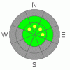
BOTTOM LINE
Danger by aspect and elevation on slopes approaching 35° or steeper.
(click HERE for tomorrow's danger rating)
|

Danger Rose Tutorial
|
While the avalanche danger is generally LOW this morning, I expect the danger will be on the rise throughout the day, especially during times of high snowfall rates or increased winds. As the storm materializes the danger will rise to MODERATE and human triggered avalanches will be possible. |
|
|
CURRENT CONDITIONS |

|
The late October storm system that laid down the cornerstone of our winter snowpack melted off most sunny slopes during the recent bout of summer-like weather. Currently, riding and turning conditions are limited to upper elevation north facing slopes above about 9,500' in elevation. |
|
|
RECENT ACTIVITY |

|
No new avalanche activity to report. |
|
|
THREAT #1 |

|
| WHERE |
PROBABILITY |
SIZE |
TREND |
|
|
|
|
| |
|
|
Over the next
24 hours.
|
|
|
The preexisting October snow has grown weak at the surface, but it's pretty straightforward and easy to detect- confined to steep, upper elevation, northerly facing slopes... that's the good news. The bad news is- that's exactly the kind of terrain we're gonna head to during this first series of storms to avoid slamming into rocks on the slopes that melted off in the past few weeks. A good looking shot of snow, coupled with gusty winds will create wind slabs which will become sensitive to the weight of a rider, especially as the day wares on. Remember- while you might not get buried, triggering a slide this early in the season is going to result in a body bruising and possibly season ending injury. If you want to get out and ride, play it safe and avoid steep, wind drifted slopes or just stick to low angle terrain. |
|
|
MOUNTAIN WEATHER |

|
A winter-like Pacific storm system and accompanying cold front will cross the area today through tonight. Heavy snow is expected along this front late this morning through early afternoon. A moist and unstable northwest flow will persist tonight into Tuesday morning. Storm totals should be in the 12"-18" range. Another storm materializes late Tuesday, though storm totals look rather light, just about 6" or so. |
|
|
GENERAL ANNOUNCEMENTS |
The information in this advisory expires 24 hours after the date and time posted, but will be updated by 7:00 AM Saturday November 13th.
If you’re getting out and about and trigger an avalanche or see anything interesting please drop me an email at craig@utahavalanchecenter.org or call 801-231-2170
Also, now is a great time to schedule one of our free avalanche awareness presentations for your group or club. Email or call me and we’ll get you booked before things get too crazy. |
|
|
This information does not apply to developed ski areas or highways where avalanche control is normally done. This advisory is from the U.S.D.A. Forest Service, which is solely responsible for its content. This advisory describes general avalanche conditions and local variations always occur. |
|
This advisory provided by the USDA Forest Service, in partnership with:
The Friends of the Utah Avalanche Center, Utah Division of State Parks and Recreation, Utah Division of Emergency Management, Salt Lake County, Salt Lake Unified Fire Authority and the friends of the La Sal Avalanche Center. See our Sponsors Page for a complete list. |
