SPECIAL ANNOUNCEMENT |
 |
Today, Sunday April 11th will be the last of our regularly scheduled Uinta avalanche advisories... seems like we've done this before-
Thank you… thank you… thank you. Thanks to everyone who was involved with or helped support this program. Of course, huge thanks to Ted Scroggin from the Evanston Ranger District for being the man with the plan and for all his timely and accurate snow and avalanche observations and for helping to educate countless riders and skiers alike. Ted is an enormous asset to the community and I couldn’t pull this off without his help. Also, the Utah Avalanche Center wants to recognize the incredible support from both the Evanston and Heber/Kamas Ranger Districts. We appreciate all Steve Ryberg, Rick Schuler and Jeff Schramm do for us and look forward to next season as we continue strengthening our partnership. Furthermore, thanks to my good colleagues at the Avalanche Center. In particular, big thanks to Grant Helgeson for all his hard work with our Avy Essentials class, helping out wit the Uinta program and for all the positive energy he brings to the table.
In addition, big thanks to Fred Hayes and all the staff at Utah State Parks for being such awesome partners, helping to fund this and other snowmobile specific avalanche advisory programs, ultimately saving many lives. The support from our good friends at Tri-City Performance in partnership with Polaris is simply amazing. Their sleds enable us to get into more terrain, see more snow and ultimately issue more precise forecasts along with providing critical outreach. Also, thanks to everyone from the Park City Powder Cats. The strong working partnership and information sharing conduit forged the past few years should be a model for all organizations in this business… thanks guys and gals!
Finally, thanks to all of you who consistently help this program, in particular the Utah Snowmobile Association, The Rocky Mountain Sledders, Dan Gardiner and the Boondockers crew along with the Thunderstruck posse. Whether attending or organizing fundraisers, lending a hand installing beacon training sites or sharing your avalanche insights and experience, I’m grateful for all the support… y’all rock!
I’ll update this advisory with some general information on Monday April 12th. |
|
|
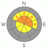
BOTTOM LINE
Danger by aspect and elevation on slopes approaching 35° or steeper.
(click HERE for tomorrow's danger rating)
|
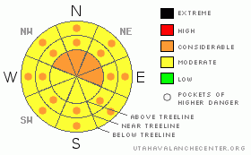
Danger Rose Tutorial
|
At mid and upper elevations the avalanche danger is MODERATE and human triggered dry snow avalanches are possible. In the wind zone above treeline pockets of CONSIDERABLE danger exist and human triggered slides are probable, especially in steep, rocky terrain. Avalanches triggered today on slopes with these characteristics will be large and dangerous.
The danger of wet avalanches is MODERATE this morning, but may rise to CONSIDERABLE on steep sunny slopes with daytime heating. |
|
|
CURRENT CONDITIONS |

|
A few clouds are drifting over the region and overnight low temperatures provided a shallow, surface refreeze as a very mild southerly flow develops ahead of our next storm system. South and southeast winds are cranking in the 30’s and 40’s along the ridges, blasting into the upper 60’s near the high peaks. It was a very warm night in the mountains and currently temperatures are in the mid to upper 30’s. While most of the surface snow is worked and worn out, there are still a few patches of damp, creamy powder on protected upper elevation north facing slopes.
|
|
|
RECENT ACTIVITY |

|
It was an active day on the eastern front with two large, snowmobile triggered slides reported. The first in the 1000 Peaks area pulled out a slab connected to a piece of cornice and was reported as up to 10’ deep and 400’ wide, burying two sledders- one to their waist the other with just their head poking out of the snow. Fortunately everyone was OK. Thanks to Bruce for the great info!
Another sled triggered slide near Bald Mountain Pass broke on weak, shallow snow near some rocks and pulled out a slide about 100’ wide and up to 6’ deep. Again, everyone came out unscathed. Thanks to Paul for keeping us updated.
In addition, the range came unglued earlier in the week and many big slides can be seen nearly everywhere you look in the high country. Click here for recent observations. |
|
|
THREAT #1 |

|
| WHERE |
PROBABILITY |
SIZE |
TREND |
|
|
|
|
| |
|
|
Over the next
24 hours.
|
|
|
The lack of a solid refreeze last night may help to reactivate some of the deeper buried weak layers in our snowpack. While my brain tells me most slopes are good to go, given the history of our snowpack and its weak, sugary, basal structure, my gut tells me to continue to play it safe and avoid steep slopes that didn’t avalanche during the big cycle. Because of our general lack of snow all winter, this is a much different season than other years and terrain that we usually head to in the spring because it’s deep and stable doesn’t necessarily apply this year. Take a look around today at all the carnage- the broken trees, the gullies filled up with 20’ feet of snow, slopes you didn’t think could avalanche, but broke to the ground- and you’ll quickly realize that if you screw up with your snowpack stability evaluation the consequences will be devastating. There are miles and miles of terrain to ride today and not even have to worry about avalanches. But if you want to get into steep, upper elevation terrain safely, don’t even think about pulling the dogs tail today. Instead, go for slopes that already slid big during the storm. |
|
|
THREAT #2 |

|
| WHERE |
PROBABILITY |
SIZE |
TREND |

|
|
|
|
| |
|
|
Over the next
24 hours.
|
|
|
Cornices have grown HUGE and may break back further than you might expect. Give these unpredictable giants the respect they deserve and don’t even monkey around with them. |
|
|
THREAT #3 |

|
| WHERE |
PROBABILITY |
SIZE |
TREND |

|
|
|
|
| |
|
|
Over the next
24 hours.
|
|
|
Depending on cloud cover and temperatures, the danger of wet avalanches will increase as the day wares on. Today you’ll want to get off of and out from under steep, sun exposed slopes during the heat of the day, especially in lower elevation terrain . |
|
|
MOUNTAIN WEATHER |

|
A very warm and windy day with partly cloudy skies is on tap for us. Highs at 8,000’ reach into the mid 50’s and at 10,000’ in the upper 40’s. Southerly winds will average 30-40 mph with gusts near 80 mph along the high peaks. Southerly winds continue to increase through today and tonight, ahead of a cold front crossing the state from the west tomorrow. Another marginal refreeze is slated for tonight with lows dipping into the mid 30’s. Clouds thicken on Monday and snow showers develop along and behind the front late in the day through tomorrow night. A good shot of snow should impact the region on Tuesday with warm, dry high pressure returning for the latter half of the week.
|
|
|
GENERAL ANNOUNCEMENTS |
The information in this advisory expires 24 hours after the date and time posted, but will be updated by with some general avalanche information on Monday April 12, 2010.
If you’re getting out and about and trigger an avalanche or see anything interesting please drop us an email at craig@utahavalanchecenter.org or call 801-231-2170
Also, we've installed two beacon checkers exclusively for snowmobiler's- one at the Noblett's Trailhead, the other at the Bear River Trailhead. Thanks to Backcountry Access, the Bear River Lodge for donating one of the units and the great folks at the National Weather Service for their partnership, support and hard work making this project happen. Click here for a brief tutorial. |
|
|
This information does not apply to developed ski areas or highways where avalanche control is normally done. This advisory is from the U.S.D.A. Forest Service, which is solely responsible for its content. This advisory describes general avalanche conditions and local variations always occur. |
|
This advisory provided by the USDA Forest Service, in partnership with:
The Friends of the Utah Avalanche Center, Utah Division of State Parks and Recreation, Utah Division of Emergency Management, Salt Lake County, Salt Lake Unified Fire Authority and the friends of the La Sal Avalanche Center. See our Sponsors Page for a complete list. |
