SPECIAL ANNOUNCEMENT |
 |
DANGEROUS AVALANCHE CONDITIONS WILL PERSIST TODAY DUE TO RECENT HEAVY SNOWFALL AND STRONG WINDS. BACK COUNTRY TRAVELERS SHOULD AVOID TRAVEL ON AND BELOW STEEP SLOPES. |
|
|
BOTTOM LINE
Danger by aspect and elevation on slopes approaching 35° or steeper.
(click HERE for tomorrow's danger rating)
|
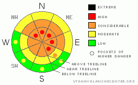
Danger Rose Tutorial
|
At mid and upper elevations the avalanche danger is CONSIDERABLE and human triggered avalanches are probable. In the wind zone above treeline a HIGH danger exists and human triggered slides are likely. In either case, avalanches triggered today will be large and dangerous. In lower elevation terrain the avalanche danger is MODERATE on any steep, wind drifted slope and human triggered avalanches are possible.
The danger of wet avalanches will rise to MODERATE on steep sunny slopes.
If you’re looking for LOW avalanche danger, stick with gentle angled slopes and meadows with no steep slopes above or adjacent to where you’re riding. |
|
|
CURRENT CONDITIONS |

|
High pressure building over the region ushers in clear skies and cold morning temperatures in the single digits. Westerly winds raged in the 50’s and 60’s nearly all day Tuesday, switching to the northwest early Wednesday and backing off into the 20’s and 30’s. It’s been an impressive storm cycle for the eastern front and snow totals on the North Slope since April Fool’s Day are nearing 55” with closer to three feet in the southern half of the range. |
|
|
RECENT ACTIVITY |

|
The place came unglued. Click here for recent observations. |
|
|
THREAT #1 |

|
| WHERE |
PROBABILITY |
SIZE |
TREND |
|
|
|
|
| |
|
|
Over the next
24 hours.
|
|
|
The winds have been brutal along the ridges, loading leeward slopes and forming dangerous hard slabs, especially in terrain facing the north half of the compass. Hard slabs are deceptively tricky because they allow us to get well out onto the slope before failing, often breaking above us. Avalanches triggered within the fresh wind drifts can easily break into older layers of storm snow, creating a much larger slide than you might be prepared to deal with. Today you’ll want to avoid any fat looking, rounded pillow of snow, particularly if it sounds hollow like a drum.
At lower elevations the wind wasn’t quite as ruthless, but the storm snow will still be reactive to the weight of a rider. Expect to find manageable soft slabs breaking around your skis or sled on steep, wind loaded slopes. |
|
|
THREAT #2 |

|
| WHERE |
PROBABILITY |
SIZE |
TREND |

|
|
|
|
| |
|
|
Over the next
24 hours.
|
|
|
Cornices have grown HUGE and may break back further than you might expect. Give these unpredictable giants the respect they deserve and don’t even monkey around with them. |
|
|
THREAT #3 |

|
| WHERE |
PROBABILITY |
SIZE |
TREND |
|
| No probability identified. |
|
|
|
|
|
All this new snow will see its first shot of strong spring sun and the danger of wet avalanches will increase as the day wares on. Today you’ll want to get off of and out from under steep, sun exposed slopes during the heat of the day, especially in lower elevation terrain . |
|
|
MOUNTAIN WEATHER |

|
It’ll be a spectacular day in the mountains with temperatures rising into the low 30’s at 8,000’ and mid 20’s at 10,000’. Overnight lows dive into the mid teens. Winds should diminish throughout the day and blow 15-25 mph along the high ridges. Sunny skies and rapid warming is on tap for Thursday with highs reaching into the upper 40’s. A weak cold front brushes by the state late in the week, ushering in cooler temperatures and light snowfall. |
|
|
GENERAL ANNOUNCEMENTS |
The information in this advisory expires 24 hours after the date and time posted, but will be updated by 7:00 AM Saturday April 10, 2010.
If you’re getting out and about and trigger an avalanche or see anything interesting please drop us an email at craig@utahavalanchecenter.org or call 801-231-2170
Also, we've installed two beacon checkers exclusively for snowmobiler's- one at the Noblett's Trailhead, the other at the Bear River Trailhead. Thanks to Backcountry Access, the Bear River Lodge for donating one of the units and the great folks at the National Weather Service for their partnership, support and hard work making this project happen. Click here for a brief tutorial. |
|
|
This information does not apply to developed ski areas or highways where avalanche control is normally done. This advisory is from the U.S.D.A. Forest Service, which is solely responsible for its content. This advisory describes general avalanche conditions and local variations always occur. |
|
This advisory provided by the USDA Forest Service, in partnership with:
The Friends of the Utah Avalanche Center, Utah Division of State Parks and Recreation, Utah Division of Emergency Management, Salt Lake County, Salt Lake Unified Fire Authority and the friends of the La Sal Avalanche Center. See our Sponsors Page for a complete list. |
