SPECIAL ANNOUNCEMENT |
 |
Thank you… thank you… thank you. Thanks to everyone who was involved with or helped support this program. Of course, huge thanks to Ted Scroggin from the Evanston Ranger District for being the man with the plan and for all his timely and accurate snow and avalanche observations and for helping to educate countless riders and skiers alike. Ted is an enormous asset to the community and I couldn’t pull this off without his help. Also, the Utah Avalanche Center wants to recognize the incredible support from both the Evanston and Heber/Kamas Ranger Districts. We appreciate all Steve Ryberg, Rick Schuler and Jeff Schramm do for us and look forward to next season as we continue strengthening our partnership. Furthermore, thanks to my good colleagues at the Avalanche Center. In particular, big thanks to Grant Helgeson for all his hard work with our Avy Essentials class, helping out wit the Uinta program and for all the positive energy he brings to the table.
In addition, big thanks to Fred Hayes and all the staff at Utah State Parks for being such awesome partners, helping to fund this and other snowmobile specific avalanche advisory programs, ultimately saving many lives. The support from our good friends at Tri-City Performance in partnership with Polaris is simply amazing. Their sleds enable us to get into more terrain, see more snow and ultimately issue more precise forecasts along with providing critical outreach. Also, thanks to everyone from the Park City Powder Cats. The strong working partnership and information sharing conduit forged the past few years should be a model for all organizations in this business… thanks guys and gals!
Finally, thanks to all of you who consistently help this program, in particular the Utah Snowmobile Association, The Rocky Mountain Sledders, Dan Gardiner and the Boondockers crew along with the Thunderstruck posse. Whether attending or organizing fundraisers, lending a hand installing beacon training sites or sharing your avalanche insights and experience, I’m grateful for all the support… y’all rock!
Today is the last of our regularly scheduled avalanche advisories for the western Uinta’s. I’ll update this advisory with some general information on Monday April 5th.
|
|
|
BOTTOM LINE
Danger by aspect and elevation on slopes approaching 35° or steeper.
(click HERE for tomorrow's danger rating)
|
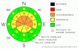
Danger Rose Tutorial
|
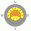
At mid and upper elevations on the North Slope the avalanche danger is CONSIDERABLE today and human triggered avalanches are probable, especially on steep, wind drifted slopes facing the north half of the compass. The south half of the region received less storm snow this week and the avalanche danger is MODERATE. Human triggered avalanches are possible in steep, wind drifted terrain.
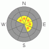
While the danger for wet avalanches is generally LOW this morning, once the sun comes out for any length of time, the danger will quickly rise to MODERATE on all steep sun exposed slopes, especially those at lower elevations.
|
|
|
CURRENT CONDITIONS |

|
A fast moving storm overnight deposited 6”-8” of new snow across the range. Currently, skies are cloudy, light snow is falling and temperatures are in the mid teens at 10,000’ and near 20 degrees at the trailheads. Winds were ruthless yesterday, blasting in the 60’s and 70’s out of the west and northwest, mellowing out by late in the day to a cattle huddling (Ted tells me it’s a Wyoming thing) 30- 40 mph and now this morning they’re northeasterly at 15-25 mph. With close to four feet of new snow since Wednesday, riding and turning conditions are nearing epic proportions for the western Uinta Mountains.
|
|
|
RECENT ACTIVITY |

|
Shallow soft slabs and sluffing in the new storm snow were reported on steep north facing slopes. Click here for recent observations.
|
|
|
THREAT #1 |

|
| WHERE |
PROBABILITY |
SIZE |
TREND |
|
|
|
|
| |
|
|
Over the next
24 hours.
|
|
|
Yesterday’s winds were brutal, moving tons of snow around rapidly loading leeward, northerly facing terrain. It seemed the slabs needed a little coaxing, but once initiated they were off to the races. While some of these instabilities probably healed overnight, I’d suspect there are plenty of steep, wind loaded slopes that will still be sensitive to the additional weight of a rider today. Making matters a little trickier is that yesterday’s wind slabs are now covered over with last night’s new snow, so they’ll be a little harder to detect. Today, you’ll want to continue avoiding any fat looking, rounded pillow of snow and look for clues like cracking around your skis or sled. If you’re unsure about the snows stability, it’s easy to get quick, solid information from small test slopes similar in aspect, elevation and slope angle to what you wanna ride. See how they’re reacting before getting after big, committing terrain.
|
|
|
THREAT #2 |

|
| WHERE |
PROBABILITY |
SIZE |
TREND |

|
|
|
|
| |
|
|
Over the next
24 hours.
|
|
|
Strong sunshine should make an appearance today and wet avalanches, especially on steep, lower elevation slopes are going to be an issue. If the snow you’re riding on gets damp and gloppy, simply move to a shadier slope where the surface snow isn’t taking on as much heat. In addition, avoid terrain traps like gullies and road cuts where even a small slide can stack up tons of wet avalanche debris.
|
|
|
THREAT #3 |

|
| WHERE |
PROBABILITY |
SIZE |
TREND |
|
|
|
|
| |
|
|
Over the next
24 hours.
|
|
|
Cornices have grown HUGE the past few days and may break back further than you might expect. Give these unpredictable giants the respect they deserve and don’t even monkey around with them.
|
|
|
MOUNTAIN WEATHER |

|
Snow showers should rapidly exit the state this morning and a nice sunny day is in store for the region. Highs today at 8,000’ reach into the mid 30’s and at 10,000’ in the upper 20’s. Under mostly cloudy skies, overnight lows dip into the mid 20’s. Winds remain behaved most of the day, increasing out of the south and southwest towards sundown and gusting into the 50’s along the ridges. A quick moving system blasts through the region overnight, before a stronger storm settles in for Monday and Tuesday producing significant snowfall. High pressure develops for the latter half of the week and another system possible for next weekend.
|
|
|
GENERAL ANNOUNCEMENTS |
The information in this advisory expires 24 hours after the date and time posted, but will be updated with some general information by 7:00 AM Monday April 5, 2010.
If you’re getting out and about and trigger an avalanche or see anything interesting please drop us an email at craig@utahavalanchecenter.org or call 801-231-2170
Also, we've installed two beacon checkers exclusively for snowmobiler's- one at the Noblett's Trailhead, the other at the Bear River Trailhead. Thanks to Backcountry Access, the Bear River Lodge for donating one of the units and the great folks at the National Weather Service for their partnership, support and hard work making this project happen. Click here for a brief tutorial. |
|
|
This information does not apply to developed ski areas or highways where avalanche control is normally done. This advisory is from the U.S.D.A. Forest Service, which is solely responsible for its content. This advisory describes general avalanche conditions and local variations always occur. |
|
This advisory provided by the USDA Forest Service, in partnership with:
The Friends of the Utah Avalanche Center, Utah Division of State Parks and Recreation, Utah Division of Emergency Management, Salt Lake County, Salt Lake Unified Fire Authority and the friends of the La Sal Avalanche Center. See our Sponsors Page for a complete list. |
