SPECIAL ANNOUNCEMENT |
 |
Sunday April 4th will be the last of our regularly scheduled Uinta advisories for the season. |
|
|
BOTTOM LINE
Danger by aspect and elevation on slopes approaching 35° or steeper.
(click HERE for tomorrow's danger rating)
|
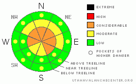
Danger Rose Tutorial
|
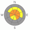
At mid and upper elevations the avalanche danger is CONSIDERABLE today and human triggered avalanches are probable, especially on steep, wind drifted slopes facing the north half of the compass. In regions that received less storm snow this week the avalanche danger is MODERATE and human triggered avalanches are possible in steep, wind drifted terrain.
While the danger for wet avalanches is generally LOW this morning, should the sun poke out for any length of time, the danger will quickly rise to MODERATE on all steep sun exposed slopes, especially those at lower elevations.
|
|
|
CURRENT CONDITIONS |

|
An active weather pattern brought another shot of snow overnight and new snow totals are pretty evenly dispersed across the region. The trailheads picked up 4” of dense, heavy snow and temperatures are in the mid to upper 20’s. Up high an additional 8” of colder, light powder stacked up and temperatures are in the mid teens. The North Slope has done well this week and new snow totals since Wednesday are close to three feet. A fly in the ointment this morning though are the winds. They picked up late yesterday afternoon, averaging 20-40 mph, but started cranking around midnight, gusting in the 60’s and 70’s along the high ridges. While many slopes are sun and wind damaged, soft, creamy powder can still be found in mid and upper elevation wind sheltered north facing terrain.
|
|
|
RECENT ACTIVITY |

|
Much of the range experienced a widespread natural avalanche cycle, though only the new storm snow got in on the act. Click here for recent observations.
|
|
|
THREAT #1 |

|
| WHERE |
PROBABILITY |
SIZE |
TREND |
|
|
|
|
| |
|
|
Over the next
24 hours.
|
|
|
Last night’s strong winds finally have some new snow to work with and they’ve have no problem whipping the snow into sensitive wind drifts. I suspect the new slabs will be several feet deep and reactive to the weight of a rider, cracking out wider and packing more of a punch than you might expect. While most of the drifting occurred along the leeward side of ridges, due to the strength of the winds, fresh slabs will have also formed a little lower down slope and cross-loaded terrain features like chutes and gullies. Today, you’ll want to continue avoiding any fat looking, rounded pillow of snow and look for clues like cracking around your skis or sled. If you’re unsure about the snows stability, it’s easy to get quick, solid information from small test slopes similar in aspect, elevation and slope angle to what you wanna ride. See how they’re reacting before getting after big, committing terrain.
|
|
|
THREAT #2 |

|
| WHERE |
PROBABILITY |
SIZE |
TREND |

|
|
|
|
| |
|
|
Over the next
24 hours.
|
|
|
Should the sun come out for any length of time, wet avalanches, especially on steep, lower elevation slopes is going to be an issue. If the snow you’re riding on gets damp and gloppy, simply move to a shadier slope where the surface snow isn’t taking on as much heat. In addition, avoid terrain traps like gullies and road cuts where even a small slide can stack up tons of wet avalanche debris.
|
|
|
MOUNTAIN WEATHER |

|
A cold front keeps snow going through the morning hours and we can expect another couple of inches before a midday break. Winds turn more westerly and continue gusting in the 50’s and 60’s along the high ridges before switching to the southwest late today and backing off slightly. High temperatures don’t vary much from where we’re at this morning and should remain in the low to mid 20’s. Overnight lows dip into the mid teens. Another shot of snow moves into the area tonight, but this should be a quick hitter and snow totals in the 2”-4” range are a good bet. A break in the action is slated for Sunday with yet another storm sliding through the region Monday and significant snow looks pretty likely with this system.
|
|
|
GENERAL ANNOUNCEMENTS |
The information in this advisory expires 24 hours after the date and time posted, but will be updated by 7:00 AM Sunday April 4, 2010.
Sunday April 4th will be the last of our regularly scheduled Uinta advisories for the season.
If you’re getting out and about and trigger an avalanche or see anything interesting please drop us an email at craig@utahavalanchecenter.org or call 801-231-2170
Also, we've installed two beacon checkers exclusively for snowmobiler's- one at the Noblett's Trailhead, the other at the Bear River Trailhead. Thanks to Backcountry Access, the Bear River Lodge for donating one of the units and the great folks at the National Weather Service for their partnership, support and hard work making this project happen. Click here for a brief tutorial. |
|
|
This information does not apply to developed ski areas or highways where avalanche control is normally done. This advisory is from the U.S.D.A. Forest Service, which is solely responsible for its content. This advisory describes general avalanche conditions and local variations always occur. |
|
This advisory provided by the USDA Forest Service, in partnership with:
The Friends of the Utah Avalanche Center, Utah Division of State Parks and Recreation, Utah Division of Emergency Management, Salt Lake County, Salt Lake Unified Fire Authority and the friends of the La Sal Avalanche Center. See our Sponsors Page for a complete list. |
