AVALANCHE WARNING »
Dangerous avalanche conditions are occuring or are imminent.
Backcountry travel in avalanche terrain is not recommended.
|
 |
Notice:
An Avalanche Warning is in effect for the western Uinta Mountains. Heavy snow combined with strong winds has rapidly overloaded a weak, pre-existing snowpack and dangerous human triggered avalanches are likely on steep slopes. People should avoid traveling in avalanche terrain today.
|
|
|
SPECIAL ANNOUNCEMENT |
 |
Sunday April 4th will be the last of our regularly scheduled Uinta advisories for the season. |
|
|
BOTTOM LINE
Danger by aspect and elevation on slopes approaching 35° or steeper.
(click HERE for tomorrow's danger rating)
|
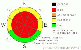
Danger Rose Tutorial
|
At mid and upper elevations the avalanche danger is HIGH today. Both natural and dangerous human triggered avalanches are likely, especially on steep, wind drifted slopes. A MODERATE avalanche danger exists in lower elevation terrain and regions that received less storm snow.
If you’re looking for terrain with LOW avalanche danger, stick to groomed trails and low angle meadows with no steep terrain above or adjacent to where you’re riding.
|
|
|
CURRENT CONDITIONS |

|
A large storm system continues to evolve over the region and the North Slope along with the eastern portion of the range has gotten pounded. Storm totals near Chepeta are over 14”, there’s 10” at Trout Creek and Trial Lake, and at Chalk Creek totals are nearing a foot. The southern half of the range really got skunked on this one and snow totals are in the 3”-5” range around Daniels and Strawberry. Winds have raged for three days and they’ve been all over the map- gusting to nearly 100 mph out of the south on Tuesday, switching to the west and northwest yesterday and blasting 40-70 mph, turning southerly and blowing in the 70’s overnight and now they’re light and northwesterly at 10-20 mph... yikes! Currently, temperatures are in the mid teens at 10,000’ and low 20’ at the trailheads.
|
|
|
RECENT ACTIVITY |

|
No new avalanche activity to report. Click here for recent observations. |
|
|
THREAT #1 |

|
| WHERE |
PROBABILITY |
SIZE |
TREND |

|
|
|
|
| |
|
|
Over the next
24 hours.
|
|
|
Our weak snowpack is up against the ropes, reeling from the combination of heavy dense snow and nuking winds from our recent storm. I’m sure some steep slopes have avalanched naturally, though many still wait for a trigger like us to come along and knock the legs from out under them. There’s no need to pull the dogs tail today. Avalanches triggered can break into weak layers of snow near the ground, producing a large and very dangerous slide. If you’re headed out for some late season riding or turns remember the Uinta snowpack isn’t deep and strong and the places we usually head for late in the season have remained thin and weak all winter, especially on the east side of the range.
|
|
|
THREAT #2 |

|
| WHERE |
PROBABILITY |
SIZE |
TREND |

|
|
|
|
| |
|
|
Over the next
24 hours.
|
|
|
Avalanches triggered in the new snow or fresh wind drifts can easily step down, breaking into weaker layers of snow, especially on steep rocky slopes with a shallow, weak snowpack. Due to the strength of the wind, drifting has occurred in unusual locations and much lower down slope than you might expect. Even if you’re playing on low angle terrain, be aware of steep slopes above and adjacent to where you’re riding.
|
|
|
MOUNTAIN WEATHER |

|
A broad Pacific trough remains over the region and another good shot of snow develops later this morning. We can expect an additional 6”-8” before things start winding down. West and northwest winds will be a nuisance, blowing 20-30 mph with gusts in the 50’s along the ridges. Highs today reach into the low 30’s at 8,000’ and mid 20’s at 10,000’. Overnight lows crash into the single digits. A break in the action for Friday, then an active weather pattern is on tap through early next week.
|
|
|
GENERAL ANNOUNCEMENTS |
The information in this advisory expires 24 hours after the date and time posted, but will be updated by 7:00 AM Friday April 2, 2010.
Sunday April 4th will be the last of our regularly scheduled Uinta advisories for the season.
If you’re getting out and about and trigger an avalanche or see anything interesting please drop us an email at craig@utahavalanchecenter.org or call 801-231-2170
Also, we've installed two beacon checkers exclusively for snowmobiler's- one at the Noblett's Trailhead, the other at the Bear River Trailhead. Thanks to Backcountry Access, the Bear River Lodge for donating one of the units and the great folks at the National Weather Service for their partnership, support and hard work making this project happen. Click here for a brief tutorial. |
|
|
This information does not apply to developed ski areas or highways where avalanche control is normally done. This advisory is from the U.S.D.A. Forest Service, which is solely responsible for its content. This advisory describes general avalanche conditions and local variations always occur. |
|
This advisory provided by the USDA Forest Service, in partnership with:
The Friends of the Utah Avalanche Center, Utah Division of State Parks and Recreation, Utah Division of Emergency Management, Salt Lake County, Salt Lake Unified Fire Authority and the friends of the La Sal Avalanche Center. See our Sponsors Page for a complete list. |
