SPECIAL ANNOUNCEMENT |
 |
Sunday April 4th will be the last of our regularly scheduled Uinta advisories for the season. |
|
|
BOTTOM LINE
Danger by aspect and elevation on slopes approaching 35° or steeper.
(click HERE for tomorrow's danger rating)
|
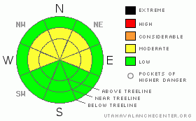
Danger Rose Tutorial
|
The avalanche danger is generally LOW this morning, but as the storm materializes the danger will rise rapidly to MODERATE, especially on steep slopes with recent wind drifts. Human triggered avalanches will be possible. Be aware of changing weather conditions, particularly if we receive more snow or wind than forecast.
|
|
|
CURRENT CONDITIONS |

|
Wow… what a crazy storm! Southerly winds raged for the past two days, reaching their crescendo late yesterday with hourly averages in the 60’s and gusts to nearly 100 mph. A respite from the blasting winds occurred for a short time overnight, but they recently picked back up and are blowing out of the southeast at 30-45 mph. So far though, it’s all blow with only about an inch or two of snow and temperatures are in the mid 20’s. Needless to say, there’s tons of wind damage and much of our terrain now resembles the surface of the moon.
|
|
|
RECENT ACTIVITY |

|
No new avalanche activity to report. Click here for recent observations.
|
|
|
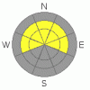
THREAT #1 |

|
| WHERE |
PROBABILITY |
SIZE |
TREND |
|
|
|
|
| |
|
|
Over the next
24 hours.
|
|
|
Winds have been nuking, finding enough old snow to blow around and form slabs, but there’s no rhyme or reason to the loading pattern. As is often the case with big wind events, drifts formed in unusual locations and your best bet is to avoid any fat, rounded looking pillow of snow. These should be easy to detect by their humpback whale-like appearance.
|
|
|
THREAT #2 |

|
| WHERE |
PROBABILITY |
SIZE |
TREND |

|
|
|
|
| |
|
|
Over the next
24 hours.
|
|
|
There’s plenty of slick bed surfaces for avalanches to run on today and sluffing should occur on steep slopes early as the new snow starts to stack up. In addition, winds will create shallow slabs on the leeward side of ridges which will become widespread and more sensitive to the weight of a rider. I expect the avalanche danger will rise towards the end of the day, so you’ll want to be flexible with your travel plans. Look for the usual signs of instability such as cracking, collapsing and of course, recent avalanche activity.
|
|
|
MOUNTAIN WEATHER |

|
A winter storm warning is in effect for the western Uinta Mountains and we can expect a shot of heavy snow developing by late afternoon. Light snow this morning should intensify throughout the day and evening with accumulations near a foot by Thursday morning. South and southeast winds gradually become stronger this afternoon, blowing in the 40’s and 50’s along the high ridges, before switching to the west and northwest late tonight. Today’s high temperatures reach into the upper 20’s before crashing into the mid teens overnight. Snow continues Thursday with another good blast expected, before tapering off late in the evening. Brief high pressure builds for Friday with an active pattern in store for the weekend and early next week.
|
|
|
GENERAL ANNOUNCEMENTS |
The information in this advisory expires 24 hours after the date and time posted, but will be updated by 7:00 AM Saturday April 3, 2010.
Sunday April 4th will be the last of our regularly scheduled Uinta advisories for the season.
If you’re getting out and about and trigger an avalanche or see anything interesting please drop us an email at craig@utahavalanchecenter.org or call 801-231-2170
Also, we've installed two beacon checkers exclusively for snowmobiler's- one at the Noblett's Trailhead, the other at the Bear River Trailhead. Thanks to Backcountry Access, the Bear River Lodge for donating one of the units and the great folks at the National Weather Service for their partnership, support and hard work making this project happen. Click here for a brief tutorial. |
|
|
This information does not apply to developed ski areas or highways where avalanche control is normally done. This advisory is from the U.S.D.A. Forest Service, which is solely responsible for its content. This advisory describes general avalanche conditions and local variations always occur. |
|
This advisory provided by the USDA Forest Service, in partnership with:
The Friends of the Utah Avalanche Center, Utah Division of State Parks and Recreation, Utah Division of Emergency Management, Salt Lake County, Salt Lake Unified Fire Authority and the friends of the La Sal Avalanche Center. See our Sponsors Page for a complete list. |
