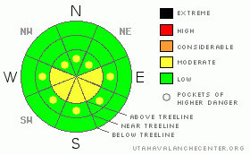
BOTTOM LINE
Danger by aspect and elevation on slopes approaching 35° or steeper.
(click HERE for tomorrow's danger rating)
|
Danger Rose Tutorial
|
The avalanche danger today is MODERATE. Strong winds coupled with 4" - 8" of new snow have produced fresh wind slabs on upper and mid elevation lee slopes, those that face W, SW, SE & E. Watch for cross-loading on slopes that face NW, N & NE.
Last night's strong refreeze and continued cool winds should keep wet avalanche activity on lock down today. But, it's really a game of temperatures. Watch for small point release wet avalanches at lower elevations late in the day. |
|
|
CURRENT CONDITIONS |

|
The North Slope faired relatively well with this last storm system, picking up 4" - 8" in the last 48 hours. Temperatures are chilly in the wake of the storm, averaging 8 F across the range. Winds were out of the NW, N & NE yesterday, shifting to E overnight. Currently winds are steady at around 15 mph, gusting to 20 out of the E-NE. Fun riding conditions exist this morning on sheltered high elevation slopes. |
|
|
RECENT ACTIVITY |

|
Ted was out poking around the North Slope yesterday, and provided some great observations. The new snow bonded well with the old crust as it fell, and no matter how hard he tried, Ted was unable to produce much sluffing within the new snow. It looks like folks were getting after over the weekend, but, we have not heard of any recent activity. |
|
|
THREAT #1 |

|
| WHERE |
PROBABILITY |
SIZE |
TREND |
|
|
|
|
| |
|
|
Over the next
24
hours.
|
|
|
While the new snow has bonded well to the old crusts, you can never turn your back on the winds in the Uintas. Winds have been a bit indecisive, but the take home message is that they have been depositing snow on E, SE, SW & W facing slopes & cross loading N, NW & NE aspects. I expect these wind slabs to be manageable and of the shallow soft slab variety. They will likely break at your machine, and so long as you are aware of them, you should be able to stay out of them. Tweak small representative test slopes to test their behavior before committing to the bigger faces. |
|
|
THREAT #2 |

|
| WHERE |
PROBABILITY |
SIZE |
TREND |
|
|
|
|
| |
|
|
Over the next
24
hours.
|
|
|
With a strong overnight refreeze & moderate winds keeping things cool, I don't expect much wet avalanche activity today. However, the new snow will be sensitive to it's first bake in the sun, so, watch for some point release wet activity late in the day on lower elevation slopes that see the most sun, those that face; W, SW, S & SE. |
|
|
MOUNTAIN WEATHER |

|
It will be a beautiful spring day in the Mountains of the Western Uintas. You can expect clear skies, a high near freezing at 10,000' with winds dying down as the clock tick's past noon. A series of weak storms move in off the pacific on Thursday which should provide overcast skies and a chance of snow. We're currently calling for 3" - 7" Friday as a more robust storm moves into the area. It looks a bit unsettled for the early weekend, but, a deep longwave trough is forecasted to take up residence over the area next week, which is favorable for more robust storm systems. In short, it ain't over yet.... |
|
|
GENERAL ANNOUNCEMENTS |
The information in this advisory expires 24 hours after the date and time posted, but will be updated by 7:00 AM Saturday March 27th, 2010.
If you’re getting out and about and trigger an avalanche or see anything interesting please drop us an email at craig@utahavalanchecenter.org or call 801-231-2170
Also, we've installed two beacon checkers exclusively for snowmobiler's- one at the Noblett's Trailhead, the other at the Bear River Trailhead. Thanks to Backcountry Access, the Bear River Lodge for donating one of the units and the great folks at the National Weather Service for their partnership, support and hard work making this project happen. Click here for a brief tutorial. |
|
|
This information does not apply to developed ski areas or highways where avalanche control is normally done. This advisory is from the U.S.D.A. Forest Service, which is solely responsible for its content. This advisory describes general avalanche conditions and local variations always occur. |
|
This advisory provided by the USDA Forest Service, in partnership with:
The Friends of the Utah Avalanche Center, Utah Division of State Parks and Recreation, Utah Division of Emergency Management, Salt Lake County, Salt Lake Unified Fire Authority and the friends of the La Sal Avalanche Center. See our Sponsors Page for a complete list. |
