BOTTOM LINE
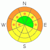
Danger by aspect and elevation on slopes approaching 35° or steeper.
(click HERE for tomorrow's danger rating)
|

Danger Rose Tutorial
|
At mid and low elevations a MODERATE avalanche danger exists and human triggered wet avalanches are possible. The danger will rise to CONSIDERABLE on steep sun exposed slopes and human triggered avalanches will become probable, especially during the heat of the day.
Deep slides that break on weak snow near the ground can still be triggered, particularly in steep, rocky terrain. A MODERATE avalanche danger exists in mid and upper elevation terrain facing the north half of the compass . Be aware- the danger is more pronounced the further east you travel in regions that received more snow out of Thursday’s storm. In addition, this side of the range generally has a weaker snowpack. |
|
|
CURRENT CONDITIONS |

|
Under clear skies a slight inversion developed overnight. Currently, temperatures are in the mid 20’s at 10,000’ and mid to upper teens at the trailheads. Westerly winds increased late yesterday and they’re blowing 25-35 mph along the high ridges. Yesterday’s cold temperatures helped preserve the new snow we received Thursday night. Cold, spring powder can still be found on upper elevation northerly facing slopes, especially on the east side of the range which received the bulk of the storm.
|
|
|
RECENT ACTIVITY |

|
Ted traveled to the east side of the range yesterday where he found a slide a couple days old that broke to the ground in steep rocky terrain. Click here for more details.
For other observations click here
|
|
|
THREAT #1 |

|
| WHERE |
PROBABILITY |
SIZE |
TREND |
|
|
|
|
| |
|
|
Over the next
24 hours.
|
|
|
Man…. talk about a blown forecast! I thought it was gonna get much warmer than it did yesterday and the place was going come apart, but a cool airmass kept the lid on the wet activity. Today however (trust me on this one) it’ll heat up fast and wet avalanches will become an issue, especially at lower elevations. While last night’s refreeze helped the snowpack in the near term, temperatures are going to rebound rapidly and the strong March sun will bake the snow surface, making it damp and cohensionless. In low and mid elevation terrain our shallow, weak snowpack is a structural junk show and the sugary facets near the ground are losing what little strength they once had. Even small, seemingly harmless wet sluffs can easily gouge deeper in the snowpack as they descend the slope, triggering wet slabs which break to the ground, piling up huge amounts of bone snapping debris. As the day heats up you’ll want to stay off of and out from under steep, sun exposed slopes and avoid terrain traps such as gullies and road cuts.
|
|
|
THREAT #2 |

|
| WHERE |
PROBABILITY |
SIZE |
TREND |

|
|
|
|
| |
|
|
Over the next
24 hours.
|
|
|
Here it is the third week of March and we’re still talking about avalanches breaking to the ground… crazy huh? The fact is, our snowpack has remained shallow and weak all season and the slide Ted found yesterday continues to confirm our suspicions. Steep, rocky slopes that are thin and weak remain suspect. While not widespread, it’s clear you can still trigger avalanches which break into weak sugary snow near the ground in this type of terrain.
|
|
|
MOUNTAIN WEATHER |

|
High pressure across the region moves east this afternoon through tonight, allowing a very mild airmass to spread across the area. Highs at 8,000' reach into the mid to upper 40's and at 10,000' in the mid 30's. Overnight lows should be right around freezing. Winds will be westerly, in the 15-30 mph range along the high peaks. A cold front will push through northern Utah Monday, giving us a dusting of snow with another small shot slated for Tuesday. High pressure builds for the mid portion of the week.
|
|
|
GENERAL ANNOUNCEMENTS |
The information in this advisory expires 24 hours after the date and time posted, but will be updated by 7:00 AM Wednesday March 24th, 2010.
If you’re getting out and about and trigger an avalanche or see anything interesting please drop us an email at craig@utahavalanchecenter.org or call 801-231-2170
Also, we've installed two beacon checkers exclusively for snowmobiler's- one at the Noblett's Trailhead, the other at the Bear River Trailhead. Thanks to Backcountry Access, the Bear River Lodge for donating one of the units and the great folks at the National Weather Service for their partnership, support and hard work making this project happen. Click here for a brief tutorial. |
|
|
This information does not apply to developed ski areas or highways where avalanche control is normally done. This advisory is from the U.S.D.A. Forest Service, which is solely responsible for its content. This advisory describes general avalanche conditions and local variations always occur. |
|
This advisory provided by the USDA Forest Service, in partnership with:
The Friends of the Utah Avalanche Center, Utah Division of State Parks and Recreation, Utah Division of Emergency Management, Salt Lake County, Salt Lake Unified Fire Authority and the friends of the La Sal Avalanche Center. See our Sponsors Page for a complete list. |
