BOTTOM LINE
Danger by aspect and elevation on slopes approaching 35° or steeper.
(click HERE for tomorrow's danger rating)
|
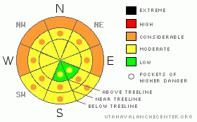
Danger Rose Tutorial
|
At mid and low elevations a MODERATE avalanche danger exists and human triggered wet avalanches are possible. The danger will rise to CONSIDERABLE on steep sun exposed slopes and human triggered avalanches will become probable, especially during the heat of the day.
On steep, wind drifted slopes at mid and upper elevations a MODERATE avalanche danger exists and human triggered slides are possible. In addition, deeper slides can still be triggered that break on weak, sugary snow near the ground, particularly in steep, rocky terrain. Be aware- the danger is more pronounced the further east you travel in regions that received more snow out of Thursday’s storm. |
|
|
CURRENT CONDITIONS |

|
In the wake of Friday’s storm, skies cleared out late yesterday afternoon and temperatures fell faster than a bad stock option. Currently it’s 9 degrees at the trailheads and just about 3 degrees at 10,000’. North and northeast winds calmed down overnight and are now blowing 15-20 mph along the high peaks and less than 10 mph near the mid elevation ridgelines. Thursday nights much advertised storm slid east of the region, grazing the North Slope where 5” of light density snow fell. The eastern half of the range fared better and Hole-in-Rock was the big winner with close to 10” of new snow. As a result the avalanche danger is more pronounced the further east you travel. |
|
|
RECENT ACTIVITY |

|
Yesterday, riders found a few shallow soft slabs and reported manageable sluffs on steep slopes.
Check out more details
here
.
|
|
|
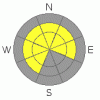
THREAT #1 |

|
| WHERE |
PROBABILITY |
SIZE |
TREND |
|
|
|
|
| |
|
|
Over the next
24 hours.
|
|
|
Wet avalanches are today’s main avalanche concern, especially at lower elevations. While last night’s refreeze helped the snowpack in the near term, temperatures are going to rebound rapidly and the strong March sun will bake the snow surface, making it damp and cohensionless. In low and mid elevation terrain our shallow, weak snowpack is a structural junk show and the sugary facets near the ground are losing what little strength they once had. Even small, seemingly harmless wet sluffs can easily gouge deeper in the snowpack as they descend the slope, triggering wet slabs which break to the ground, piling up huge amounts of bone snapping debris. As the day heats up you’ll want to stay off of and out from under steep, sun exposed slopes and avoid terrain traps such as gullies and road cuts.
|
|
|
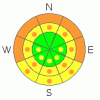
THREAT #2 |

|
| WHERE |
PROBABILITY |
SIZE |
TREND |
|
|
|
|
| |
|
|
Over the next
24 hours.
|
|
|
Northeasterly winds were relentless at the upper elevations yesterday, easily transporting the light density snow and forming sensitive, albeit shallow slabs on the leeward side of ridges. Due to the atypical wind direction, drifts have formed in unusual locations and in terrain with a westerly component to its aspect. While mostly manageable in size and easy to detect, avalanches triggered in the new snow can still break into weaker layers of snow especially in steep, rocky terrain where the snowpack has remained weak and shallow all season.
|
|
|
MOUNTAIN WEATHER |

|
High pressure camps out over the region this weekend and a significant warming trend develops. Highs today at 8,000’ reach into the mid 30’s and at 10,000’ near freezing. Overnight lows only dip into the mid 20’s. Winds will be light and northerly today, blowing less than 15 mph along the ridges. High temperatures soar on Sunday, reaching into the low to mid 40s. A weak storm is slated for the region late Monday or Tuesday with a return to high pressure expected for the latter half of the week.
|
|
|
GENERAL ANNOUNCEMENTS |
The information in this advisory expires 24 hours after the date and time posted, but will be updated by 7:00 AM Sunday March 21th, 2010.
If you’re getting out and about and trigger an avalanche or see anything interesting please drop us an email at craig@utahavalanchecenter.org or call 801-231-2170
Also, we've installed two beacon checkers exclusively for snowmobiler's- one at the Noblett's Trailhead, the other at the Bear River Trailhead. Thanks to Backcountry Access, the Bear River Lodge for donating one of the units and the great folks at the National Weather Service for their partnership, support and hard work making this project happen. Click here for a brief tutorial. |
|
|
This information does not apply to developed ski areas or highways where avalanche control is normally done. This advisory is from the U.S.D.A. Forest Service, which is solely responsible for its content. This advisory describes general avalanche conditions and local variations always occur. |
|
This advisory provided by the USDA Forest Service, in partnership with:
The Friends of the Utah Avalanche Center, Utah Division of State Parks and Recreation, Utah Division of Emergency Management, Salt Lake County, Salt Lake Unified Fire Authority and the friends of the La Sal Avalanche Center. See our Sponsors Page for a complete list. |
