BOTTOM LINE
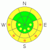
Danger by aspect and elevation on slopes approaching 35° or steeper.
(click HERE for tomorrow's danger rating)
|

Danger Rose Tutorial
|
A MODERATE avalanche danger exists today for wet avalanches. The danger will rise to CONSIDERABLE on low elevation sun exposed slopes past midday. Be on the lookout for changing conditions, signs of warming include; pinwheels & roller-balls. Avoid travel on steep sun exposed slopes once the machine starts bogging down in the wet stuff.
A MODERATE avalanche danger also exists for persistent weak layers that are stacked throughout our snowpack. You're most likely to trigger a dry “wintery’ slab avalanche in steep rocky terrain where the snowpack is thin & weak.
|
|
|
CURRENT CONDITIONS |

|
A bit of a temperature inversion is in place this morning. Temperatures at 8000' average 26 F, 9000' temps are a degree warmer, while 11,000' temps are at 30 F.
Nuking winds over the weekend along with intense solar heating the last two days have made for some "interesting" riding conditions. Almost all aspects have developed a sun crust, with the exception being sheltered high elevation north facing slopes, where you can still find a decent turn or two.
|
|
|
RECENT ACTIVITY |

|
Ted and I were out poking around on the North Slope yesterday and found a recent avalanche cycle in the Superbowl area. Check out the details here. A few wet avalanches were observed in the Smith & Morhouse area on east facing slopes around 8500'.
|
|
|
THREAT #1 |

|
| WHERE |
PROBABILITY |
SIZE |
TREND |
|
|
|
|
| |
|
|
Over the next
24
hours.
|
|
|
Today should be another scorcher, with temps at 11,000' exceeding 40 F today. Combine this with a mild overnight refreeze & very light forecasted winds, and you have all the ingredients for wet avalanches.
Riding this time of year is a game of timing, and the clock starts ticking the moment the sun comes out. While the melt/freeze crust is supporting our weight, things are more or less good to go, but once the midday sun begins to saturate the snow, wet avalanches become more likely. Once it begins to heat up around lunch time, avoid travel on steep sunny slopes.
Signs of too much warming include a machine bogging down in the wet stuff & snowballs turning to pin-wheels. Remember, the snowpack doesn't like rapid changes, so if you're feeling too hot, the snowpack probably is too.
|
|
|
THREAT #2 |

|
| WHERE |
PROBABILITY |
SIZE |
TREND |

|
|
|
|
| |
|
|
Over the next
24
hours.
|
|
|
While sunny days are quickly turning our minds to spring, we can't turn out back on the persistent weak layers. Yesterday Ted and I found yet another avalanche which failed on surface hoar. It's still possible to trigger an avalanche that fails in one of the many weak layers in our snowpack. The message hasn't changed; you're most likely to have problems in steep rocky terrain where the snowpack is thin & weak.
|
|
|
MOUNTAIN WEATHER |

|
Today will be the warmest day yet while the ridge of high pressure continues to dominate our corner of the map. Things begin to change tomorrow afternoon as a storm system moves in from the northwest. The exact tracking of the storm is a bit hard to pin down at the moment, but, folks at the National Weather Service are calling for highest precip amounts in the Western Uintas! Storm totals are in the 8" - 16" range. Temps will cool way down too; a low of 9 F is expected on Friday. More sunny days are on tap as we enter the weekend.
|
|
|
GENERAL ANNOUNCEMENTS |
The information in this advisory expires 24 hours after the date and time posted, but will be updated by 7:00 AM Saturday March 20th, 2010.
If you’re getting out and about and trigger an avalanche or see anything interesting please drop us an email at craig@utahavalanchecenter.org or call 801-231-2170
Also, we've installed two beacon checkers exclusively for snowmobiler's- one at the Noblett's Trailhead, the other at the Bear River Trailhead. Thanks to Backcountry Access, the Bear River Lodge for donating one of the units and the great folks at the National Weather Service for their partnership, support and hard work making this project happen. Click here for a brief tutorial. |
|
|
This information does not apply to developed ski areas or highways where avalanche control is normally done. This advisory is from the U.S.D.A. Forest Service, which is solely responsible for its content. This advisory describes general avalanche conditions and local variations always occur. |
|
This advisory provided by the USDA Forest Service, in partnership with:
The Friends of the Utah Avalanche Center, Utah Division of State Parks and Recreation, Utah Division of Emergency Management, Salt Lake County, Salt Lake Unified Fire Authority and the friends of the La Sal Avalanche Center. See our Sponsors Page for a complete list. |
