SPECIAL ANNOUNCEMENT |
 |
Our thoughts and prayers are with everyone involved with the Big Iron Shootout avalanche disaster near Revelstoke, BC yesterday. It's tragic to see so many people involved with an accident that was entirely avoidable.
|
|
|
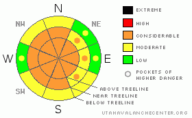
BOTTOM LINE
Danger by aspect and elevation on slopes approaching 35° or steeper.
(click HERE for tomorrow's danger rating)
|
Danger Rose Tutorial
|
Raging winds have made for a CONSIDERABLE (level 3) danger at and above tree-line due to fresh sensitive wind slabs on nearly all aspects at mid & upper elevations. The start zones are loaded, all they need now is a trigger, thus, human triggered avalanches are probable.
A CONSIDERABLE danger exists on steep slopes facing the north half of the compass, particularly where the snowpack has stayed thin and weak all season. While not widespread, human triggered avalanches which break into weak snow near the ground are probable in terrain with these characteristics.
All other slopes have a MODERATE avalanche danger.
|
|
|
CURRENT CONDITIONS |

|
Yesterday's storm just didn't produce for us; the North Slope was the "big" winner, receiving about 4" of new snow. As of 5 am, temps at 8000' average 23 F, and it's just a few degrees colder at 10,000'. While the storm turned out to be a bust for snow, it fueled a rampant wind bender. Yesterday winds blew primarily out of the SE, with a touch of E-SE as well as due E in excess of 40 mph. Around 9 pm last night winds shifted around first to the W-NW for a few hours before raging out of the N, clocking speeds near 40 mph. This storm didn't do much to improve riding conditions, there is still a nasty series of sun crusts out there, now covered with a wind slab.
|
|
|
RECENT ACTIVITY |

|
No new avalanche activity to report. Click here for recent observations. |
|
|
THREAT #1 |

|
| WHERE |
PROBABILITY |
SIZE |
TREND |

|
|
|
|
| |
|
|
Over the next
24 hours.
|
|
|
During the daylight hours, the winds loaded up N & NW facing slopes with a fresh wind slab at mid & upper elevations. Around 9 pm, the winds did a 180 and began creating fresh sensitive wind slabs on S & SE facing slopes. W & E aspects will be cross-loaded from all the activity too. It sounds complex but the take home message is quite simple; upper & mid elevation slopes are severely wind damaged on all aspects.
You can expect to find newly formed drifts at and below ridge top and around terrain features like chutes and gully walls. Shallow avalanches triggered in steep rocky terrain today can step down, breaking into weaker layers of snow as they descend the slope, creating a larger slide than you bargained for.
The best riding conditions will be likely be found in the tighter trees at mid & lower elevations. However, there is likely some surface hoar still lurking in these locations, so you'll need to watch for red flags like shooting cracks or "whoomph" sounds, as these signs indicate instability.
|
|
|
THREAT #2 |

|
| WHERE |
PROBABILITY |
SIZE |
TREND |
|
|
|
|
| |
|
|
Over the next
24
hours.
|
|
|
Craig and Ted spent Friday in God’s living room and found mostly stable conditions in high elevation, north facing terrain, especially where the snowpack is thick. However, we tend to trigger deep, scary slides where the snowpack is thin and fragile. It seems ridiculous that we’re still talking about shallow snowpacks in the middle of March, but most upper elevation snow sites are well below average, only reporting 60-70% of where we should be at this time of year. Deep, dangerous avalanches are getting harder to trigger and they’re becoming more pockety, but don’t let the lack of activity lure you into a false sense of snow security. Our snowpack is a structural junk show and much of our terrain is just waiting for a big load to get things going. While there’s a lot of hypothetical going on here, one thing is for sure- when the wind blows in the Uintas we usually see large avalanches… today should be no different.
|
|
|
MOUNTAIN WEATHER |

|
We'll see the dregs of the storm pass through today, leaving us with a couple of inches at best. Winds will be steady today out of the north at 15 - 20 mph, gusting to 30 mph plus. We start the week with a warming trend accompanied by clear skies. There is a chance of snow for the second half of the week, but nothing particularly robust is in the current forecast.
|
|
|
GENERAL ANNOUNCEMENTS |
The information in this advisory expires 24 hours after the date and time posted, but will be updated by 7:00 AM Wednesday March 17th, 2010.
If you’re getting out and about and trigger an avalanche or see anything interesting please drop us an email at craig@utahavalanchecenter.org or call 801-231-2170
Also, we've installed two beacon checkers exclusively for snowmobiler's- one at the Noblett's Trailhead, the other at the Bear River Trailhead. Thanks to Backcountry Access, the Bear River Lodge for donating one of the units and the great folks at the National Weather Service for their partnership, support and hard work making this project happen. Click here for a brief tutorial. |
|
|
This information does not apply to developed ski areas or highways where avalanche control is normally done. This advisory is from the U.S.D.A. Forest Service, which is solely responsible for its content. This advisory describes general avalanche conditions and local variations always occur. |
|
This advisory provided by the USDA Forest Service, in partnership with:
The Friends of the Utah Avalanche Center, Utah Division of State Parks and Recreation, Utah Division of Emergency Management, Salt Lake County, Salt Lake Unified Fire Authority and the friends of the La Sal Avalanche Center. See our Sponsors Page for a complete list. |
