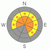
BOTTOM LINE
Danger by aspect and elevation on slopes approaching 35° or steeper.
(click HERE for tomorrow's danger rating)
|

Danger Rose Tutorial
|
In mid and upper elevation terrain, especially on steep slopes facing the north half of the compass where the snowpack has stayed thin and weak all season, the avalanche danger remains CONSIDERABLE (Level 3) and human triggered avalanches which break into weak snow near the ground are probable.
A MODERATE (Level 2) avalanche danger exists on steep, northerly facing slopes at both mid and upper elevations, where buried surface hoar remains tricky and reactive. Human triggered avalanches are possible in this type of terrain.
At lower elevations and on most sun exposed mid elevation slopes the avalanche danger is generally LOW.
|
|
|
CURRENT CONDITIONS |

|
A cool, northwesterly flow has kept a band of clouds and showers over the region, depositing 4”-6” of snow in the past 24 hours from Mirror Lake northward. The southern half of the range received 2”-3” of new snow. Winds are light and blowing out of the west-northwest, 10-15 mph with a gust or two in the low 20’s along the high ridges. Yesterday’s shot of snow added a much needed coat of new paint keeping riding and turning conditions quite good, especially in mid and upper elevation wind and sun sheltered terrain.
|
|
|
RECENT ACTIVITY |

|
Since Sunday we’ve had reports of three human triggered slides, resulting in two partial burials. One near Marion on Sunday was triggered on a layer of buried surface hoar and was 12”-18” deep and 150’ wide. Another in upper Weber Canyon broke within last weekend’s storm snow and was 1’-2’ feet deep and 100’ wide. And finally, a sled triggered slide on Yamaha Hill was 2’-3’ deep and 50’wide- initiated within the storm snow but quickly broke to the ground.
Click here for more details
|
|
|
THREAT #1 |

|
| WHERE |
PROBABILITY |
SIZE |
TREND |
|
|
|
|
| |
|
|
Over the next
24 hours.
|
|
|
Talking with some longtime North Slope locals yesterday and of course our resident expert Ted Scroggin, no one can remember a year like this where the snowpack has remained this thin for so long. As you know- thin, shallow snowpack’s are weak, dangerous snowpack’s and not much has changed with our deeper instability issues. As a matter of fact, the Yamaha Hill slide helps exemplify exactly what we’ve been talking about nearly all season- avalanches triggered within the new snow or even a fresh wind drift can quickly break into weak layers of snow near the ground. By now, you know the drill- deep, dangerous slides can still be triggered in terrain with a weak, shallow snowpack. Likely suspect terrain will be at mid and upper elevations, particularly on slopes facing the north half of the compass.
Click here for a tutorial explaining what we're seeing.
|
|
|
THREAT #2 |

|
| WHERE |
PROBABILITY |
SIZE |
TREND |
|
|
|
|
| |
|
|
Over the next
24 hours.
|
|
|
Last weekend’s storm snow is settling, gaining strength and not quite as reactive to the weight of a rider as it was a couple of days ago. In addition, there may be an old wind slab or two in the wind zone above treeline, but these seems rather lifeless as well. However it’s what’s buried and preserved underneath the new snow that still has all of us a bit on edge. A layer of surface hoar created on the evening of February 16th remains alive and well and this problematic, persistent layer of fragile, feathery crystals is now buried 1’-2’ deep. Surface hoar is often very difficult to locate in the snowpack and requires a lot of detective work, but we’ve been finding this notoriously tricky weakness on northerly facing terrain at both mid and upper elevations. These are generally manageable avalanche conditions, but can easily surprise someone and could potentially slam you into a group of trees or take you for a ride over a cliff, essentially ruining your day in a hurry.
|
|
|
MOUNTAIN WEATHER |

|
A cool, northwest flow over the area today will bring a slight chance of snow this afternoon which continues into tonight. Expect mostly cloudy skies today with a snow shower or two and northwesterly winds in the 15-25 mph range along the ridges. High temperatures at 8,000’ reach into the mid to upper 20’s and at 10,000’ near 20 degrees. Overnight lows under clearing skies dive into the low teens. Partly cloudy skies are on tap for Thursday and a much warmer, southwesterly flow is slated for the region on Friday. A storm system over the weekend will affect the southern half of the state, though we might see a residual flurry or two, before warm high pressure builds for early next week.
|
|
|
GENERAL ANNOUNCEMENTS |
The information in this advisory expires 24 hours after the date and time posted, but will be updated by 7:00 AM Saturday March 13th, 2010.
If you’re getting out and about and trigger an avalanche or see anything interesting please drop us an email at craig@utahavalanchecenter.org or call 801-231-2170
Also, we've installed two beacon checkers exclusively for snowmobiler's- one at the Noblett's Trailhead, the other at the Bear River Trailhead. Thanks to Backcountry Access, the Bear River Lodge for donating one of the units and the great folks at the National Weather Service for their partnership, support and hard work making this project happen. Click here for a brief tutorial. |
|
|
This information does not apply to developed ski areas or highways where avalanche control is normally done. This advisory is from the U.S.D.A. Forest Service, which is solely responsible for its content. This advisory describes general avalanche conditions and local variations always occur. |
|
This advisory provided by the USDA Forest Service, in partnership with:
The Friends of the Utah Avalanche Center, Utah Division of State Parks and Recreation, Utah Division of Emergency Management, Salt Lake County, Salt Lake Unified Fire Authority and the friends of the La Sal Avalanche Center. See our Sponsors Page for a complete list. |
