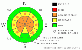
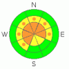
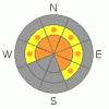
BOTTOM LINE
Danger by aspect and elevation on slopes approaching 35° or steeper.
(click HERE for tomorrow's danger rating)
|
Danger Rose Tutorial
|
In steep, mid and upper elevation terrain the avalanche danger is CONSIDERABLE (Level 3) and human triggered wind slabs along with dangerous slides which break into weak snow near the ground are probable. The danger is most pronounced in the wind zone above tree line and on steep slopes with a weak shallow snowpack, particularly those facing the north half of the compass.
A MODERATE (Level 2) avalanche danger exists on steep, mid elevation slopes, especially those with recent deposits of wind drifted snow and human triggered avalanches are possible.
At lower elevations and on most sun exposed mid elevation slopes the avalanche danger is generally LOW.
|
|
|
CURRENT CONDITIONS |

|
Clouds streamed into the region late yesterday afternoon keeping overnight low temperatures rather mild, in the low to mid 20’s. The big news however is the relentless east and southeast winds. For the past 24 hours they’ve been ruthless along the high ridges, blowing 20-30 mph with gusts in the low 40’s. At the upper elevations in the wind zone, many slopes are wind damaged, but just off the ridges in sheltered terrain, riding and turning conditions remain quite good.
|
|
|
RECENT ACTIVITY |

|
A number of pockety, human triggered wind slabs were reported from the North Slope yesterday. The largest was one Ted found near Yamaha Hill which was 12”-18” deep, 100’ wide, breaking on a 32 degree slope, failing on a layer of buried surface hoar. Click here for pics.
Click here for more observations.
|
|
|
THREAT #1 |

|
| WHERE |
PROBABILITY |
SIZE |
TREND |
|
|
|
|
| |
|
|
Over the next
24 hours.
|
|
|
Strong east and southeast winds at the upper elevations moved a tremendous amount of snow around in the past 24 hours. Due to the atypical wind direction, upper elevation terrain with a westerly component to its aspect will be loaded in an unusual fashion. In addition, today’s wind slabs will be wider, deeper and pack more of a punch and can break into weaker layers of snow as they descend the slope, particularly in terrain where the snowpack has remained shallow and weak all season. Today you’ll want to avoid any smooth looking, rounded pillow of snow.
|
|
|
THREAT #2 |

|
| WHERE |
PROBABILITY |
SIZE |
TREND |

|
|
|
|
| |
|
|
Over the next
24 hours.
|
|
|
A layer of surface hoar created on the evening of February 16th remains alive and well, reactive to the weight of a rider. This problematic, persistent layer of fragile, feathery crystals is now buried 1’-2’ deep. While not widespread and rather pockety in nature, we’ve been finding this notoriously tricky weakness on northerly facing terrain where cold air pools at both mid and upper elevations. These are generally manageable avalanche conditions, but can easily surprise someone and could potentially slam you into a group of trees or take you for a ride over a cliff, essentially ruining your day in a hurry.
|
|
|
THREAT #3 |

|
| WHERE |
PROBABILITY |
SIZE |
TREND |
|
|
|
|
| |
|
|
Over the next
24 hours.
|
|
|
Not much has changed with the deeper instability issues of our snowpack. Deep, dangerous slides can still be triggered in terrain with a weak, shallow snowpack. Likely suspect terrain will be at mid and upper elevations, particularly on slopes facing the north half of the compass.
|
|
|
MOUNTAIN WEATHER |

|
Clouds and a few snow showers are expected today, as a splitting storm system affecting the southern half of the state pushes a few bands of moisture northward. Winds are gonna remain a nuisance, blowing southeast through southwest, gusting in the low 40’s along the high ridges and peaks. High temperatures reach in the mid 30’s at 8,000’ and just about freezing at 10,000’. Overnight lows dip into the mid teens. We might see a couple inches of snow from the remnants of today’s storm before brief high pressure and clearing skies move in for Monday. Yet another splitting system is on tap for Tuesday and Wednesday. High pressure builds for the latter half of the week.
|
|
|
GENERAL ANNOUNCEMENTS |
The information in this advisory expires 24 hours after the date and time posted, but will be updated by 7:00 AM Wednesday March 10th, 2010.
If you’re getting out and about and trigger an avalanche or see anything interesting please drop us an email at craig@utahavalanchecenter.org or call 801-231-2170
Also, we've installed two beacon checkers exclusively for snowmobiler's- one at the Noblett's Trailhead, the other at the Bear River Trailhead. Thanks to Backcountry Access, the Bear River Lodge for donating one of the units and the great folks at the National Weather Service for their partnership, support and hard work making this project happen. Click here for a brief tutorial. |
|
|
This information does not apply to developed ski areas or highways where avalanche control is normally done. This advisory is from the U.S.D.A. Forest Service, which is solely responsible for its content. This advisory describes general avalanche conditions and local variations always occur. |
|
This advisory provided by the USDA Forest Service, in partnership with:
The Friends of the Utah Avalanche Center, Utah Division of State Parks and Recreation, Utah Division of Emergency Management, Salt Lake County, Salt Lake Unified Fire Authority and the friends of the La Sal Avalanche Center. See our Sponsors Page for a complete list. |
