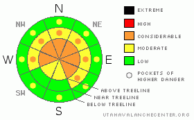
BOTTOM LINE
Danger by aspect and elevation on slopes approaching 35° or steeper.
(click HERE for tomorrow's danger rating)
|
Danger Rose Tutorial
|
In steep, mid and upper elevation terrain the avalanche danger is CONSIDERABLE (Level 3) and human triggered wind slabs along with dangerous slides which break into weak snow near the ground are probable. The danger is most pronounced on steep slopes with a weak, shallow snowpack, particularly those facing north, northeast and east.
A MODERATE (Level 2) avalanche danger exists on steep, mid elevation slopes, especially those with recent deposits of wind drifted snow and human triggered avalanches are possible.
The danger of wet slides is generally LOW this morning, increasing to MODERATE on all steep, low elevation slopes with daytime heating. Human triggered avalanches are possible, especially during the heat of the day.
|
|
|
CURRENT CONDITIONS |

|
Skies cleared out late last night as high pressure began to briefly build over the region. Southeasterly winds picked up around 1:00 this morning and they’re currently blowing 15-25 mph along the high peaks. It’s crisp out there with temperatures in the low to mid teens. Thursday night’s storm was good to the Uinta’s, especially the North Slope where 12”-18” stacked up with a few favorable locations receiving close to two feet. South of Mirror Lake Highway storm totals are about that amount. There’s some wind damage in upper elevation open terrain, but overall riding and turning conditions are the best they’ve been all season… it’s over-the-head and over-the-hood.
|
|
|
RECENT ACTIVITY |

|
Countless new snow avalanches, one to two feet deep, can be seen on nearly every aspect on steep slopes throughout the range. In addition, we were able to trigger several manageable soft slabs in steep, wind loaded terrain, all breaking within the new snow. Click here for more details.
|
|
|
THREAT #1 |

|
| WHERE |
PROBABILITY |
SIZE |
TREND |

|
|
|
|
| |
|
|
Over the next
24 hours.
|
|
|
The Uinta’s finally got walloped with an epic, late winter storm. You’d think that with all this new snow the range would be coming unglued, but the light fluffy snow only had an inch of water and the snowpack seems to be adjusting in the short term. Yesterday we found mostly manageable soft slab avalanches, predictably breaking at or just below your skis, board or sled. Today, there’s still plenty of terrain harboring sensitive wind drifts, especially those with an easterly component to their aspect. Wind drifts, sensitive to the weight of a rider, will be found on the leeward side of upper elevation ridges and cross loaded around terrain features like chutes, gullies and sub-ridges. Avalanches triggered within the freshly formed drifts can easily get out of hand, breaking into weaker snow, producing a larger avalanche, particularly in steep, rocky terrain. Slope cuts are an effective tool to see how the snow is gonna react. They’re best performed on small test slopes with little consequence similar in aspect, elevation and slope angle to what you wanna ride. See how these are reacting before center punching a big open bowl or ripping a steep committing line.
|
|
|
THREAT #2 |

|
| WHERE |
PROBABILITY |
SIZE |
TREND |

|
|
|
|
| |
|
|
Over the next
24 hours.
|
|
|
You’d think that by the beginning of March all our deep instabilities would be nicely healed, we could get into big terrain with no worries and just like most other winters, ride it if it’s white. Unfortunately that’s not the case this year and it would be easy to get lulled into the false sense of security, getting into steep, radical terrain like we do every spring. This hasn’t been a typical winter and our snowpack is far from deep and stable. As a matter of fact, my snowpit stability tests yesterday were alarming and I was able to get columns to break to the ground with little effort. Sure, you may be able to ride plenty of steep terrain without incident, but those that have been thin and weak all year are still suspect. It’s the same as it ever was…. same as it ever was- avalanches can still break into weak snow near the ground, especially in steep, rocky terrain with a shallow weak snowpack facing the north half of the compass.
|
|
|
THREAT #3 |

|
| WHERE |
PROBABILITY |
SIZE |
TREND |
|
|
|
|
| |
|
|
Over the next
24 hours.
|
|
|
The sun is getting powerful, easily baking lower elevation slopes, making the snow damp, manky and reactive to slope cuts. The danger of low elevation wet avalanches on steep slopes will rise on all aspects with daytime heating. Avoid terrain traps like gullies and road cuts, especially during the heat of the day, where even a small slide will stack up tons of bone twisting debris.
|
|
|
MOUNTAIN WEATHER |

|
It’ll be a beautiful morning in the mountains with sunny skies, light winds and warming temperatures. Highs at 8,000’ should near 40 degrees and at 10,000 close to freezing. Thin clouds move in later today, keeping overnight lows at bay only dropping into the low 20’s. Winds should remain reasonable, out of the east and southeast, blowing less than 20 mph. A splitting system dives south overnight, though we may see a few flurries as part of this impulse wanders to the north. Mostly cloudy skies and a snow shower or two are on tap for Sunday. An unsettled pattern could bring some hope of another storm for Tuesday, but right now it’s still a roll of the dice.
|
|
|
GENERAL ANNOUNCEMENTS |
The information in this advisory expires 24 hours after the date and time posted, but will be updated by 7:00 AM Sunday March 7th, 2010.
If you’re getting out and about and trigger an avalanche or see anything interesting please drop us an email at craig@utahavalanchecenter.org or call 801-231-2170
Also, we've installed two beacon checkers exclusively for snowmobiler's- one at the Noblett's Trailhead, the other at the Bear River Trailhead. Thanks to Backcountry Access, the Bear River Lodge for donating one of the units and the great folks at the National Weather Service for their partnership, support and hard work making this project happen. Click here for a brief tutorial. |
|
|
This information does not apply to developed ski areas or highways where avalanche control is normally done. This advisory is from the U.S.D.A. Forest Service, which is solely responsible for its content. This advisory describes general avalanche conditions and local variations always occur. |
|
This advisory provided by the USDA Forest Service, in partnership with:
The Friends of the Utah Avalanche Center, Utah Division of State Parks and Recreation, Utah Division of Emergency Management, Salt Lake County, Salt Lake Unified Fire Authority and the friends of the La Sal Avalanche Center. See our Sponsors Page for a complete list. |
