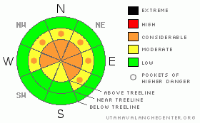
BOTTOM LINE
Danger by aspect and elevation on slopes approaching 35° or steeper.
(click HERE for tomorrow's danger rating)
|
Danger Rose Tutorial
|
In steep, rocky, mid and upper elevation terrain the stability pattern remains tricky and the avalanche danger is CONSIDERABLE (Level 3). Human triggered wind slabs along with dangerous slides which break into weak snow near the ground are probable in this type of terrain. The danger is most pronounced on steep slopes with a weak, shallow snowpack.
A MODERATE (Level 2) avalanche danger exists on steep, mid elevation slopes, especially those with recent deposits of wind drifted snow and human triggered avalanches are possible.
Low elevation terrain and most mid elevation sun exposed slopes have a LOW avalanche danger.
|
|
|
CURRENT CONDITIONS |

|
A wimpy little storm slid through the region late last night depositing an inch of new snow in the upper elevation terrain surrounding the North Slope. Skies are partly to mostly cloudy, southwesterly winds are blowing 15-25 mph and temperatures are mild, in the mid to upper 20’s. Riding and turning conditions remain a bit of a mixed bag. Up high, most of the open terrain is wind jacked and down low the snow is crusted from the strengthening March sun. However, you can still find soft, creamy powder on wind and sun sheltered northerly aspects.
|
|
|
RECENT ACTIVITY |

|
Ted discovered no less than 6 unintentionally triggered slides in the Moffit Basin yesterday. Four in the Super Bowl and a handful more near Humpy Peak. All the slides were breaking on a layer of preserved surface hoar and these pockety slides are 12”-18” deep and 100’ wide. Click here for more details.
|
|
|
THREAT #1 |

|
| WHERE |
PROBABILITY |
SIZE |
TREND |
|
|
|
|
| |
|
|
Over the next
24 hours.
|
|
|
As if our snowpack didn’t have enough issues already, yet another persistent weakness, this time a layer of buried surface hoar added a whole new dimension to our already challenging snowpack. These fragile, feathery crystals formed on the evening of the 16th are now preserved under a stiff slab created by Sunday’s wind event and they’re extremely hard to detect in the snowpack. While still fairly manageable in depth, avalanches are breaking much wider than you’d expect and have the potential to step down into weaker snow, especially in terrain with a shallow snowpack, triggering a larger slide than you bargained for. Your best bet is to keep your slope angles toned down and think about the consequences of your terrain choices should you trigger an avalanche.
|
|
|
THREAT #2 |

|
| WHERE |
PROBABILITY |
SIZE |
TREND |

|
|
|
|
| |
|
|
Over the next
24 hours.
|
|
|
Our old nemeses, the deep instabilities near the ground are alive and continue to lose strength, especially in terrain where the snowpack is less than about three feet deep or so. This weak, sugary snow is having the time of its life, partying like it’s 1999. But when a big storm comes along, especially one with some strong winds or significant water weight, the snowpack will be reeling with a hangover like no other. Right now the snowpack is the weakest I’ve ever seen it for this late in the season and today you can still trigger deep, dangerous avalanches which break to the ground, particularly in steep, rocky terrain.
|
|
|
MOUNTAIN WEATHER |

|
A flurry or two along with mostly cloudy skies and mild temperatures are on tap today as a weak system brushes by the area. Southwest winds should remain in the 15-25 mph range with a few gusts in the low 30’s along the high ridges. Temperatures reach into the mid 30’s at 8,000’ and upper 20’s at 10,000’. Overnight lows under cloudy skies dip into the mid 20’s. A more potent storm moves into the region tonight through Friday and it looks like this system holds together enough to give us a good shot of snow. Accumulations by Friday morning should be near a foot.
|
|
|
GENERAL ANNOUNCEMENTS |
The information in this advisory expires 24 hours after the date and time posted, but will be updated by 7:00 AM Saturday March 6th, 2010.
If you’re getting out and about and trigger an avalanche or see anything interesting please drop us an email at craig@utahavalanchecenter.org or call 801-231-2170
Also, we've installed two beacon checkers exclusively for snowmobiler's- one at the Noblett's Trailhead, the other at the Bear River Trailhead. Thanks to Backcountry Access, the Bear River Lodge for donating one of the units and the great folks at the National Weather Service for their partnership, support and hard work making this project happen. Click here for a brief tutorial. |
|
|
This information does not apply to developed ski areas or highways where avalanche control is normally done. This advisory is from the U.S.D.A. Forest Service, which is solely responsible for its content. This advisory describes general avalanche conditions and local variations always occur. |
|
This advisory provided by the USDA Forest Service, in partnership with:
The Friends of the Utah Avalanche Center, Utah Division of State Parks and Recreation, Utah Division of Emergency Management, Salt Lake County, Salt Lake Unified Fire Authority and the friends of the La Sal Avalanche Center. See our Sponsors Page for a complete list. |
