SPECIAL ANNOUNCEMENT |
 |
Many thanks to all who attended yesterday’s Avy Essentials Class. An awesome day for sure with some great peeps and by all accounts a tremendous success! I also want to thank Weber County Search and Rescue for the very generous donation to the Avalanche Center and to Dan and Phatty for sharing their riding expertise with the group… man these guys can rip. And finally, to my great colleagues- Grant Helgeson and Reid Persing- for all your hard work making this event happen, and of course to Ted Scroggin who was out bustin’ avies yesterday while we had our hands full teaching the class. Needless to say… you guys rock! |
|
|
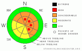
BOTTOM LINE
Danger by aspect and elevation on slopes approaching 35° or steeper.
(click HERE for tomorrow's danger rating)
|
Danger Rose Tutorial
|
In steep, rocky, mid and upper elevation terrain the stability pattern remains complicated and the avalanche danger is CONSIDERABLE (Level 3) especially on slopes with an easterly component to their aspect. Human triggered wind slabs along with dangerous slides which break into weak snow near the ground are probable in this type of terrain. The danger is most pronounced on steep slopes with a weak, shallow snowpack. In the wind zone pockets of HIGH (Level 4) avalanche danger exist and human triggered avalanche are likely.
A MODERATE (Level 2) avalanche danger exists on steep, mid elevation slopes, especially those with recent deposits of wind drifted snow and human triggered avalanches are possible.
Low elevation terrain and most mid elevation sun exposed slopes have a LOW avalanche danger. |
|
|
CURRENT CONDITIONS |

|
A cool, northerly flow over the region ushered in a few flurries and an inch of new snow overnight. Southwest winds blew steadily all day yesterday, in the 25-35 mph range, but died off around 2:00 this morning and are currently blowing less than 5 mph even along the highest peaks. Temperatures are in the low to mid 20’s. Yesterday’s wind damaged many upper elevation slopes and open bowls, but soft settled powder will still be found on sheltered, shady slopes. |
|
|
RECENT ACTIVITY |

|
Four human triggered slides occurred yesterday, all as a result of the recent strong winds. On the North Slope, Ted remotely triggered a large piece of snow from a low angle slope about 100’ away on the east face of Lofty Lake Peak. The slide was 3’ deep, about 250’ wide, breaking to the ground on weak, faceted snow. Fortunately, due to his experience and expert route finding skills Ted wasn’t caught. Also, a snowmobiler triggered a fresh wind slab on Double Hill that appeared to be 2’ deep and around 75’ wide. In upper Weber Canyon a very knowledgeable skier with decades of avalanche experience, triggered a slide which broke out above him, but was able to skirt off to the side and fortunately wasn’t caught. This slide was just over a foot deep, about 400’ wide and ran for over 600’ vertically, stacking up a deep pile of debris in a gully. In addition, we’re still waiting to hear the details surrounding yet another human triggered slide, this one in the Chalk Creek area which sounds like a smaller pocket, but significant none-the-less. Click here for pics and details on these slides. |
|
|
THREAT #1 |

|
| WHERE |
PROBABILITY |
SIZE |
TREND |

|
|
|
|
| |
|
|
Over the next
24 hours.
|
|
|
Winds continued to move lots of snow around yesterday and I think fresh drifts will remain sensitive to the weight of a rider today. While most slabs are found on the leeward side of mid and upper elevation ridgelines, there was also quite a bit of cross loading around terrain features like chutes, gullies and sub-ridges. In addition, terrain is loaded a little further down slope than you might expect. Avalanches triggered within these fresh drifts can easily break into weaker layers of snow as they descend the slope, breaking out wider and deeper than you might have bargained for. Today you’ll want to avoid any fat looking, rounded pillow of snow, especially those that feel hollow or have a drum-like sound to them. |
|
|
THREAT #2 |

|
| WHERE |
PROBABILITY |
SIZE |
TREND |
|
|
|
|
| |
|
|
Over the next
24 hours.
|
|
|
The western Uinta Mountains don’t get much snow, but this moisture challenged range sure makes up for it with wind. The past few days winds have been relentless, gusting into the 30’s and 40’s out of the west and southwest, moving lots of snow around, overloading our weak snowpack and causing it to go through a rapid change. Our fragile house of cards snowpack interprets this sudden load just like a big storm and many slopes hang in the balance waiting for us to come along and tip the scales. Making matters worse, recent winds created a dense, strong slab and the snow feel solid under your skis, board or machine, allowing you to get well out onto the slope before it fails. These are exactly the type of conditions where we see most avalanche accidents and close calls in the western Uinta’s. Today, you’ll need to continue evaluating steep slopes on an individual basis because the snowpack is highly variable in both depth and strength and can dramatically change from one drainage to another. Steep, mid and upper elevation terrain, especially those with an easterly component to their aspect that have a strong slab resting on weak sugary snow are likely suspects. Avalanches triggered on slopes with these characteristics will be deep, wide and dangerous. |
|
|
MOUNTAIN WEATHER |

|
Mostly cloudy skies, cool temperatures and a flurry or two are on tap as the bulk of today’s storm continues sliding south. Northwesterly winds should increase slightly and blow 5-15 mph along the ridges. Highs today reach into the upper 30’s at 8,000’ and near freezing at 10,000’. Overnight lows dive into the teens under partly cloudy skies. Sunny skies and warming temperatures prevail until mid week when another splitting storm brings a slight chance of snow sometime Wednesday. |
|
|
GENERAL ANNOUNCEMENTS |
The information in this advisory expires 24 hours after the date and time posted, but will be updated by 7:00 AM Wednesday March 3rd, 2010.
If you’re getting out and about and trigger an avalanche or see anything interesting please drop us an email at craig@utahavalanchecenter.org or call 801-231-2170
Also, we've installed two beacon checkers exclusively for snowmobiler's- one at the Noblett's Trailhead, the other at the Bear River Trailhead. Thanks to Backcountry Access, the Bear River Lodge for donating one of the units and the great folks at the National Weather Service for their partnership, support and hard work making this project happen. Click here for a brief tutorial. |
|
|
This information does not apply to developed ski areas or highways where avalanche control is normally done. This advisory is from the U.S.D.A. Forest Service, which is solely responsible for its content. This advisory describes general avalanche conditions and local variations always occur. |
|
This advisory provided by the USDA Forest Service, in partnership with:
The Friends of the Utah Avalanche Center, Utah Division of State Parks and Recreation, Utah Division of Emergency Management, Salt Lake County, Salt Lake Unified Fire Authority and the friends of the La Sal Avalanche Center. See our Sponsors Page for a complete list. |
