SPECIAL ANNOUNCEMENT |
|
|
|
BOTTOM LINE
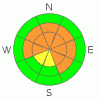
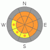
Danger by aspect and elevation on slopes approaching 35° or steeper.
(click HERE for tomorrow's danger rating)
|
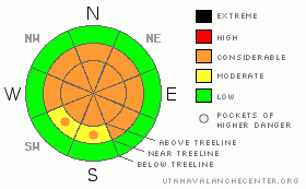
Danger Rose Tutorial
|
In steep, rocky, mid and upper elevation terrain the stability pattern remains complicated and the avalanche danger is CONSIDERABLE (Level 3) especially on slopes with an easterly component to their aspect. Human triggered wind slabs along with dangerous slides which break into weak snow near the ground are probable in this type of terrain. The danger is most pronounced on steep slopes with a weak, shallow snowpack.
A MODERATE avalanche danger exists on steep, mid elevation slopes, especially those with recent deposits of wind drifted snow and human triggered avalanches are possible.
Low elevation terrain and most mid elevation sun exposed slopes have a LOW avalanche danger. |
|
|
CURRENT CONDITIONS |

|
High clouds filtered into the area late yesterday afternoon, ahead of a yet another storm system taking a southerly track through the state. Southwest winds increased overnight as well, blowing 25-35 mph with a few gusts in the low 40’s along the high ridges. Currently, temperatures are in the upper teens at 10,000’ and mid 20’s at 8,000’. The midweek storm deposited 6” of new snow at the upper elevations and cold, settled powder can still be found on wind sheltered, shady slopes. |
|
|
RECENT ACTIVITY |

|
On Friday, a sledder triggered an avalanche on a steep, east-southeast aspect just off the Duchesene Ridge at about 9,800’ in elevation. The slide was 150’ wide, breaking on weak snow near the ground, partially burying both the rider and sled. Fortunately everyone came out unscathed.Click here for pics.
On Thursday explosive testing in the 1000 Peaks area pulled out a hard slab avalanche to the ground, on an east-northeast aspect at about 10,200’ in elevation. The slide averaged 3’ feet deep, was 350’ wide and ran for 600’ vertically.Click here for pics.
Click here for more Uinta snowpack observations. |
|
|
THREAT #1 |

|
| WHERE |
PROBABILITY |
SIZE |
TREND |
|
|
|
|
| |
|
|
Over the next
24 hours.
|
|
|
A whole new batch of fresh wind drifts formed overnight and these will be sensitive to the weight of a rider today. Most of the slabs will be found on the leeward side of mid and upper elevation ridgelines and around terrain features like chutes, gullies and sub-ridges. Avalanches triggered within these fresh drifts can easily break into weaker layers of snow as they descend the slope, breaking out wider and deeper than you might expect. Today you’ll want to avoid any fat looking, rounded pillow of snow, especially those that feel hollow or have a drum-like sound to them. |
|
|
THREAT #2 |

|
| WHERE |
PROBABILITY |
SIZE |
TREND |
|
|
|
|
| |
|
|
Over the next
24 hours.
|
|
|
Let’s face it… our snowpack has issues. Here it is almost March and at just over four feet deep, our seasonal snow totals are only about 60% of average. With below average snowfall, our pack is shallow and as you already know- shallow snow is weak snow- weak snow is dangerous snow and our house of cards snowpack isn’t gaining strength like it should be for this time of year. It’s an unusual winter and usual weather makes unusual avalanches. Sounds simple, but the fact is it’s very tricky out there. Sure, you can ride plenty of slopes without triggering a slide, but of course it gets old riding low angle terrain and we start getting onto steeper slopes because usually by this time of year they’re good to go. However, this year is much different than years past and steep, rocky slopes that have remained thin all season are exactly the kind of terrain where you can still trigger avalanches that break on weak snow near the ground. Making matters worse, recent winds will make the snow feel strong and solid under your skis, board or machine, allowing you to get well out onto the slope before it fails. These are exactly the type of conditions where we see most avalanche accidents and close calls in the western Uinta’s. |
|
|
MOUNTAIN WEATHER |

|
Today’s storm dives south, leaving us with mostly cloudy skies, warm temperatures and gusty ridge top winds. Southerly winds will be a nuisance, blowing 20-30 mph along the ridges with a few gusts in the mid 40’s near the high peaks. High temperatures at 8,000’ will be near 40 degrees and at 10,000’ near freezing. Overnight lows dip into the teens. We may see a few snow showers overnight as colder air seeps into the region. There’s a continued possibly of a flurry or two for Sunday, before high pressure builds for the beginning of the week. |
|
|
GENERAL ANNOUNCEMENTS |
The information in this advisory expires 24 hours after the date and time posted, but will be updated by 7:00 AM Sunday February 28th, 2010.
If you’re getting out and about and trigger an avalanche or see anything interesting please drop us an email at craig@utahavalanchecenter.org or call 801-231-2170
Come join forecasters from the UAC along with the talented athletes from Boondockers for our second annual Essential Avy and Riding Skills Workshop. Click here for more details.
Also, we've installed two beacon checkers exclusively for snowmobiler's- one at the Noblett's Trailhead, the other at the Bear River Trailhead. Thanks to Backcountry Access, the Bear River Lodge for donating one of the units and the great folks at the National Weather Service for their partnership, support and hard work making this project happen. Click here for a brief tutorial. |
|
|
This information does not apply to developed ski areas or highways where avalanche control is normally done. This advisory is from the U.S.D.A. Forest Service, which is solely responsible for its content. This advisory describes general avalanche conditions and local variations always occur. |
|
This advisory provided by the USDA Forest Service, in partnership with:
The Friends of the Utah Avalanche Center, Utah Division of State Parks and Recreation, Utah Division of Emergency Management, Salt Lake County, Salt Lake Unified Fire Authority and the friends of the La Sal Avalanche Center. See our Sponsors Page for a complete list. |
